- Culebrinas River
-
Culebrinas River (Río Culebrinas) River 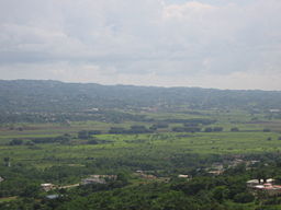 Looking south, the Culebrinas River and valley just west of the municipality of Moca. Summer 2008.
Country United States Region Puerto Rico Source - coordinates 18°16′21″N 66°53′39″W / 18.2725°N 66.89417°W Mouth Mona Passage - elevation 0 ft (0 m) - coordinates 18°24′21″N 67°10′37″W / 18.40583°N 67.17694°W Length 25 mi (40.2 km) Basin 105 sq mi (272 km2) [1][2] The Culebrinas River (Spanish: Río Culebrinas; pron. koo-le-BREE-nahs), is a river in northwest Puerto Rico. It originates in southwestern Lares and flows for 25 miles (40 km) till it empties into the Mona Passage south of downtown Aguadilla.
Contents
Variant names
- Río Culebrinas
- Rio Culebrinas
- Rio de Colovrinas[1]
History
Christopher Columbus is said to have anchored and come ashore near the mouth of the Culebrinas River in 1493. A stone cross monument was erected to mark the site, but it was destroyed by the 1918 Puerto Rico earthquake.[3][4]
Flooding
In 2007, Tropical Storm Olga caused flooding on the river, forcing an evacuation.[5]
References
- ^ a b U.S. Geological Survey Geographic Names Information System: Río Culebrinas. Retrieved on 2008-08-13.
- ^ RIO CULEBRINAS AT AGUADILLA. U.S. Army Corps of Engineers - Johnsonville District. Retrieved on 2008-08-13.
- ^ Van Deusen, Richard James; Elizabeth Kneipple Van Deusen (1931). Porto Rico: A Caribbean Isle. H. Holt. pp. p. 48. OCLC 569158.
- ^ U.S. Puerto Rico Reconstruction Administration, Writers' Program (1940). Puerto Rico: A Guide to the Island of Boriquén. The University Society. pp. p. 68. OCLC 245805.
- ^ "Storm Olga floods Puerto Rico, drenches Hispaniola". Reuters. 11 December 2007. http://www.reuters.com/article/worldNews/idUSNCB53337620071212. Retrieved 2008-08-13.
External links
- Culebrinas River - The Columbia Gazetteer of North America at Bartleby.com
Categories:- Rivers of Puerto Rico
- Puerto Rico geography stubs

Wikimedia Foundation. 2010.