- Lima (Paraguay)
infobox city
official_name = Lima
motto
imagesize =
image_caption =
imagesize =
image_caption =
image_shield = Coat_of_arms_of_Paraguay.svg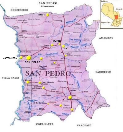
mapsize = 200px
map_caption =
subdivision_type = Country
subdivision_name =Paraguay
subdivision_type1 = Department
subdivision_name1 = San Pedro
leader_title = Intendente municipal
leader_name = Julio César Franco Sosa
established_title = Founder
established_date = 1792Fray Pedro Bartolomé
area_magnitude =
area_total_sq_mi =
area_total_km2 = 992
area_land_sq_mi =
area_land_km2 =
area_water_sq_mi =
area_water_km2 =
area_water_percent =
area_urban_sq_mi =
area_urban_km2 =
area_metro_sq_mi =
area_metro_km2 =
population_as_of = 2008
population_note =
population_total = 10,367
population_metro =
population_urban =
population_density_km2 = 13
population_density_sq_mi =
timezone = -4 Gmt
utc_offset =
timezone_DST =
utc_offset_DST =
latd= |latm= |lats= |latNS=
longd= |longm= |longs= |longEW=
elevation_m =
elevation_ft =
postal_code_type = Postal code
postal_code = 8430
area_code =
website =Lima is a town of the Department of San Pedro
Paraguay . Its capital is the city ofSan Pedro de Ycuamandiyú .District of Lima
One of the districts of the Second Department of San Pedro
Paraguay , which is more than 330km from the cityAsuncion .It was founded in the year 1792 and it is credited to Fray Pedro Bartolome, as a mission with Guanás Indians, on the shores of Aguaray River.
Lima was founded in the year 1901, as the 2nd district. Department of San Pedro.
With an area of approximately 992
km² , and an estimated population of 10,367 InhabLocated on the River Aguaray Guazú, whose main activities are livestock, the exploitation of mate and some agricultural crops.
With its population of about 10,367 inhabitants it has a density of 13 inhabitants /
km² .It also has airfields for small and medium-sized machines.
Geography
This district is accessible by Route 3 General Elizardo Aquino, and Route No. 11 Juana de Lara.
Other routes are without pavement.
The internal roads do not have any kind of paving.
Today, this district has public transport services with interdistrict services and daily services up to the country's capital, and also to
Ciudad del Este Pedro Juan Caballero Brazil ,Argentina andChile .The District has an airport (runway).
It’s bordered on the north by the District of
Nueva Germania and the District of Santa Rosa del Aguaray, both districts separated by the Aguaray Guazú River.To the south are the District of San Pablo and the District of
Choré . The Jejui Guazú River; separates the two districts.To the east lies the District
General Isidro Resquín . At the west lies the District ofSan Pedro de Ycuamandiyú , and the District of Nueva Germania, the Aguaray Guazú River separates both districts.Hydrography
Rio Aguaray Guazú, its beaches are creamy, its white sand draws people in times of very hot weather.
The Jejui Guazú River is the least polluted river in the country.
Climate
It is wet and rainy, the relative humidity is 70 to 80%. The average temperature is 23 °C, the highest in summer is 35 °C and the least is 10 °C.
Language
The predominant language is Guarani, that is approximately spoken by the 80% of the population. Spanish and Guarani (yopara) is spoken by 20% of the remaining population.
Demographics
The District of Lima, according to the National Housing Census for 2002 has a total population of 10,367 inhabitants. In the urban area the amount is of 2,131 inhabitants, and in the rural area is 8,236 inhabitants.
Its rural population is 79.44% of the total population.
The total households in the district amounts to the amount of 2,064, of which corresponds to households in urban areas the number of 506, and in rural areas the number of 1,558 households, representing 75.48% of the households living in rural areas.
According to the projection of the district's total population, by gender and year have the following details:
* By the year 2008 the total population will be of 11,125 inhabitants, of whom 5,860 men and 5,265 women.
* By 2009, the total population will be of 11,192 inhabitants, of whom 5,898 men and 5,294 women.
* By 2010, the total population will be of 11,260 inhabitants, of whom 5,936 men and 5,324 women.
* By the year 2011, the total population will be of 11,304 inhabitants, of whom 5,962 men and 5,342 women.
* By the year 2012, the total population will be of 11,349 inhabitants, of whom 5,989 men and 5,361 women.
* By the year 2013, the total population will be of 11,394 inhabitants, of whom 6,015 men and 5,379 women.As for the main socio-demographic indicators, the district of Lima has the following details:
* Population Less than 15 years 43.5%.
* Average of 3.6 children per woman.
* Illiterate: 8.4%.
* Employed by the primary sector: 67.6%.
* Employed by the secondary sector: 6.3% ..
* Employed in the tertiary sector: 25.1%.
* Occupied work in the agricultural field: 67.3%.
* Homes with electricity: 78.4%.
* Homes with running water: 41.0%.History
It is one of the typical populations born at the end of eighteenth century to retain a strong Franciscan mark, while Choré and Guayaybi are notable for their intense agricultural production. Until today it retains its old adobe church, built in colonial times.
At present, "INDERT", formerly the Rural Welfare Institute, has enabled the following:
Communal Fields:
In the year 1984, by Resolution No. 1753, with an area of 146
has . The Colony Sargento Montanía.In the year 1998, by Resolution No. 1165, with an area of 179 ha. The Colony San Jose del Norte.
There are also colonies: Loma Clavel, with an area of 180
has . Mayor Hermosa-COSTA PUCU with an area of 1167 hectares. And the Mayor of Hermosa-Sgto. Montania.Ecological Reserves:
In the District of Lima, is the Ecological Reserve CAPIITINDY with an area of 102 hectares, which was created in the year 1995, by Resolution No. 1251.
Indigenous Colonies:
It is the community AVARIYU with an area of 237 ha, in the years 1980 and 1991, by Resolution No. 789.799, and 1623 respectively.
Economy
The city is a major center of activity that includes livestock production of cattle, horses, sheep and pigs.
In agriculture, there are crops in the district like mate,
cotton ,tobacco ,sugar cane ,cassava ,sesame , cedrón Paraguay,soy ,beans ,potatoes ,alfalfa , citrus, peanuts, wheat and cassava. Oranges; sour and sweet, andsunflower .The main activity of its residents is the development of mate.
68.7% of the department’s population is poor and the while the rest of the population is not considered poor, the needs are very marked, their average monthly income per family is of 496,645 Guarani, representing a per person average monthly income of 95,915 Guarani.
Livestock: cattle, horses, pigs.
Tourism
The beaches that are watered by the River Aguaray Guazú are of white and crystal sand, which atracts domestic tourism. It also has health resorts, farms and a square that are the attractions of the city.
The health resort Raul Valiente, has beautiful beaches on the River Aguaray and has Quinchos, sports fields, changing rooms, canteens, etc.It is a private place, managed by an association of taxi drivers.
As an attraction it retains its old adobe church, built in times of Spanish Colony, in honor of
San Francisco andVirgen del Rosario , although a more modern temple has been built.References
* Geografía del Paraguay - Editorial Hispana Paraguay S.R.L.- 1a. Edición 1999 - Asunción Paraguay
* Geografía Ilustrada del Paraguay - ISBN 99925-68-04-06 - Distribuidora Arami S.R.L.
* La Magia de nuestra tierra. Fundación en Alianza. Asunción. 2007.
* EVP - Wikipedia
* [http://www.evp.edu.py/index.php?title=Portada Enciclopedia Virtual Paraguaya - Portal]External links
* [http://www.senatur.gov.py/ Secretaria Nacional de Turismo]
Wikimedia Foundation. 2010.