Buttermilk Falls (Hamilton, Ontario)
- Buttermilk Falls (Hamilton, Ontario)
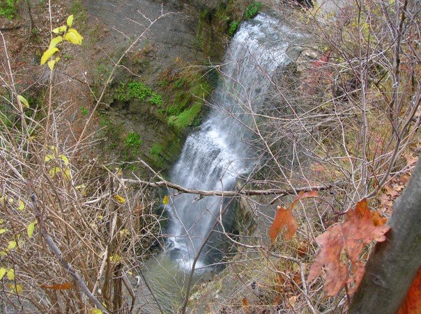
Infobox Waterfall
name = Buttermilk Falls
image_size =
caption = Buttermilk Falls
location = Hamilton, Ontario
latitude =
longitude =
coordinates = coord|43.203925|-79.820480
elevation =
type = Plunge
height = convert|23|m|ft|abbr=on
width = convert|8|m|ft|abbr=on
height_longest =
average_width =
number_drops =
average_flow =
watercourse = Red Hill Creek
world_rank =
"Buttermilk Falls" is a 23 metre high plunge waterfall found below "Oak Knoll Park" (adjacent to King's Forest Park, "Mountain Brow Boulevard" and Limeridge Road East in Hamilton, Ontario, Canada.[cite web|publisher=(www.cityofwaterfalls.ca)| title =Hamilton- Waterfall Capital of the World| url=http://www.cityofwaterfalls.ca/| accessdate = 2008-07-22] ]Best viewed after a major rain storm. From this location you get a stunning view of the "Red Hill Valley."
Nearby attractions include the Albion Falls, Escarpment Rail Trail, Felker's Falls, scenic views of Hamilton, Chippawa Rail Trail, King’s Forest Golf Course and Park, Mohawk Sports Park, Gage Park, Hamilton Children's Museum and the Bruce Trail.[cite web|url=http://www.conservationhamilton.ca/parks/visit/Buttermilk_falls.asp|title=Hamilton Conservation Authority: Parks & Attractions- Buttermilk Falls|accessdate=2008-07-22] ]Directions
On Hamilton mountain travel east on Mohawk Road until you get to "Mountain Brow Boulevard" where you will follow it to the first parking lot on the left side. This is called Oak Knoll Park, pull in this parking lot and then walk to Buttermilk Falls.[cite web|url=http://www.conservationhamilton.ca/parks/visit/Buttermilk_falls.asp|title=Hamilton Conservation Authority: Parks & Attractions- Buttermilk Falls|accessdate=2008-07-22] ]References
External links
* [http://www.cityofwaterfalls.ca/ Hamilton- "The Waterfall Capital of the World" (www.cityofwaterfalls.ca)]
* [http://www.brucetrail.org Bruce Trail (www.brucetrail.org)]
* [http://www.hamiltonpostcards.com/pages/waterfalls.html Vintage Postcards: Waterfalls in and around Hamilton, Ontario]
Maps
* [http://map.hamilton.ca/Static/PDFs/General%20Interest%20maps/Overall%20City/WaterfallMap.pdf Hamilton Waterfall Map PDF. (http://map.hamilton.ca)]
* [http://www.hamiltonnature.org/waterfalls/waterfalls.html
) ]
]
Wikimedia Foundation.
2010.
Look at other dictionaries:
Albion Falls (Hamilton, Ontario) — Infobox Waterfall name = Albion Falls image size = caption = Albion Falls location = Hamilton, Ontario latitude = longitude = coordinates = coord|43.200472|N|79.819676|W elevation = type = Cascade height = convert|19|m|ft|abbr=on width =… … Wikipedia
Glendale Falls (Hamilton, Ontario) — Infobox Waterfall name = Glendale Falls image size = caption = Glendale Falls location = Hamilton, Ontario latitude = longitude = coordinates = elevation = type = Terraced Classic height = convert|3|m|ft|abbr=on width = convert|5.5|m|ft|abbr=on… … Wikipedia
Cochrane Road (Hamilton, Ontario) — Albion Falls, King s Forest Park See also: List of streets in Hamilton, Ontario Cochrane Road is a two way Lower City collector road in Hamilton, Ontario, Canada. It starts off at the Queenston Traffic Circle and travels South between the… … Wikipedia
Limeridge Road (Hamilton, Ontario) — Limeridge Road is a two way Upper City (mountain) collector road in Hamilton, Ontario, Canada. It starts off just West of Garth Street at William McCulloch Park and cuts across the Hamilton mountain eastward running parallel with the Lincoln M.… … Wikipedia
List of waterfalls in Hamilton, Ontario — Hamilton, Ontario is home to more than 100 waterfalls and cascades, most of which are on or near the Bruce Trail as it winds through the Niagara Escarpment. Hamilton known as The City of Waterfalls brands itself as The Waterfall Capital of The… … Wikipedia
Hamilton Conservation Authority — The Hamilton Conservation Authority maintains the greenspace, trails, parks and some attractions in the Hamilton, Ontario, Canada.The Hamilton Conservation Authority (HCA) has managed the natural environment in partnership with the City of… … Wikipedia
Niagara Falls State Park — Niagara Reservation U.S. National Register of Historic Places U.S. National Historic Landmark … Wikipedia
Chittenango Falls State Park — Photo of Chittenango Falls taken in May from the footbridge spanning the creek … Wikipedia
List of New York state parks — This is a list of state parks and state historic sites in the U.S. state of New York. Contents 1 Forest Preserve 2 State Parks 3 State Historic Sites 4 … Wikipedia
Governors Island — This article is about Governors Island in New York Harbor. For other uses, see Governors Island (disambiguation). Governors Island U.S. National Register of Historic Places … Wikipedia