- Zoersel
infobox Belgium Municipality
name=Zoersel
picture=
picture-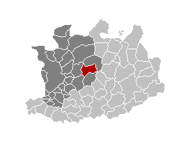
map-
arms=Zoersel.jpg
region=BE-REG-FLE
community=BE-NL
province=BE-PROV-AN
arrondissement=Antwerp
nis=11055
pyramid-date=
0-19=
18-64=
65=
foreigners=
foreigners-date=
mayor=Katrien Schryvers (CD&V)
majority=CD&V ,Groen! ,N-VA ,sp.a
postal-codes=2980
telephone-area=03
web= [http://www.zoersel.be/ www.zoersel.be]
lat_deg=51
lat_min=16
lon_deg=04
lon_min=42|Zoersel is a
municipality located in the Belgian province of Antwerp. The municipality comprises the towns of Halle, St. Antonius and Zoersel proper. OnJanuary 1 2006 Zoersel had a total population of 20,638. The total area is 38.65 km² which gives apopulation density of 534 inhabitants per km².External links
* [http://www.zoersel.be Official website]


Wikimedia Foundation. 2010.