- Fort Street-Pleasant Street and Norfolk & Western Railroad Viaduct
Infobox_nrhp | name =Fort Street—Pleasant Street and Norfolk & Western Railroad Viaduct
nrhp_type =
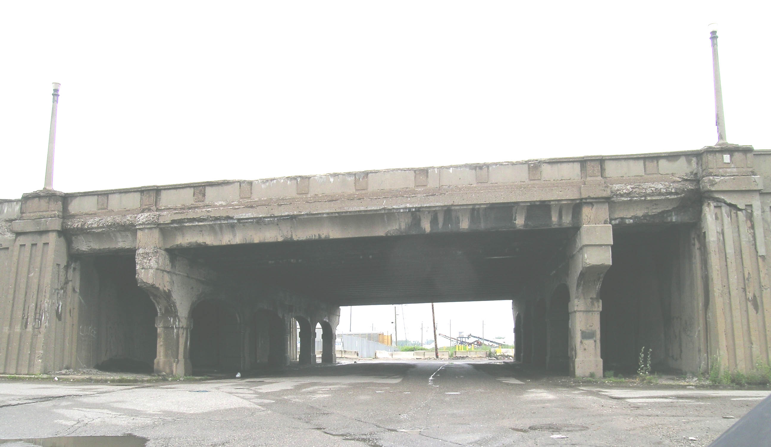
caption = Pleasant Street at Fort, looking north
location=Detroit, Michigan
lat_degrees = 42
lat_minutes = 17
lat_seconds = 4
lat_direction = N
long_degrees = 83
long_minutes = 8
long_seconds = 54
long_direction = W
locmapin = Michigan
area =
built =1928
architect= Wayne County Road Commission
architecture= Other
added =February 18 ,2000
governing_body = Local
mpsub=Highway Bridges of Michigan MPS
refnum=00000116cite web|url=http://www.nr.nps.gov/|title=National Register Information System|date=2008-04-15|work=National Register of Historic Places|publisher=National Park Service]The Fort Street—Pleasant Street and Norfolk & Western Railroad Viaduct is a bridge carrying Fort Street over both Pleasant Street and the broad expanse of tracks from the Norfolk & Western Railroad in
Detroit ,Michigan , just west of theRouge River .History
The area along the Fort Street corridor near Pleasant Street was transformed early in the 20th century from a residential community to a substantially industrial center. [http://www.michigan.gov/mdot/0,1607,7-151-9620_11154_11188-29399--,00.html Fort St. / Pleasant St. & NW Railroad] from the Michigan Department of Transportation] An undated newspaper clipping from the time on the "passing of Fort Street West" laments, " [o] nce a social center, it is now a great business artery whose splendid mansions have given way before the march of industrial progress." Among other industrial centers in the area, the
Ford River Rouge Complex is just upstream from the Fort Road (as it was named at the time) river crossing, making both Fort Road and the Norfolk & Western tracks main transportation arteries in Detroit.In the 1920s, Fort Road was one of the roads chosen for upgrade to a "superhighway." These roads were upgraded by the city, county and state to feature 204-foot right-of-ways, central medians, and nighttime lighting. Additionally, with the growth in vehicular traffic in the early 20th century, railroad-highway intersections increasingly became sources of both travel delays and accidents. On 1928, the Wayne County Road Commission and the Michigan State Highway Department announced plans to separate rail and vehicle grades, with railways contributing substantially to the cost. The Fort Road bridge project was the first to be undertaken.
Howeverm the project had substantial design considerations, resulting in a large cost and a lengthy planning process. The bridge was required to be long enough to permit passage of both two city streets and twelve railroad tracks at an oblique angle; it had to be wide enough to accommodate two 40-foot paved traffic surfaces for the Fort Superhighway. Construction finally began in summer 1928, and the structure was completed in 1930.
The resulting structure, according to a Wayne County Road Commission at the time, included an "ornamental concrete handrail" supporting "ornamental concrete lamp posts" so that "the entire project will be adequately and beautifully lighted." In subsequent years, the urn-shaped balusters of the original railing have been replaced by solid concrete panels. However, the other components of the railings, including the octagonal lamp posts, remain intact. The loss of he balusters is unfortunate, but the overall scale and significance of the bridge outweighs the minor loss.
Significance
The Fort Street Viaduct is noteworthy for both its design and size. It was normally cheaper to build a rail road bridge over the street rather than the other way around. However, the large number of tracks at the Fort Road crossing would have required a substantial subway. The Fort Street Viaduct, which stretches 2,800 feet in length and includes an 80-foot roadway, was by far the largest and most ambitious structure included in the 1920s grade separation plan. This bridge exemplifies the importance attached to the grade separation program, as planners tried to increase vehicle safety and decrease congestion.
References
Wikimedia Foundation. 2010.