- Cannelton Locks and Dam
Infobox_Dam
dam_name=Cannelton Locks and Dam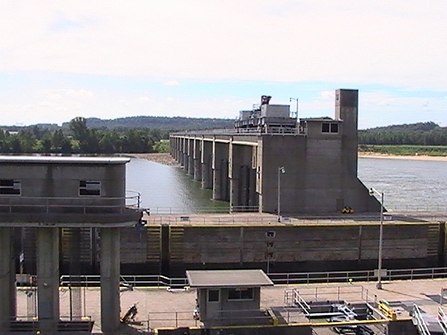
caption=
official_name=
crosses=Ohio River
reservoir=
locale=
maint=United States Army Corps of Engineers Louisville District
length=1,827 ft (556.9 m)
height=
width=
began=July 1963
open=December 1966
closed=
cost=
reservoir_capacity=
reservoir_catchment=
reservoir_surface=
bridge_carries=
bridge_width=
bridge_clearance=
bridge_traffic=
bridge_toll=
bridge_id=
map_cue=
map_
map_text=
map_width=
coordinates= coord|37|53|59|N|86|42|21|W|type:landmark_region:US|display=inline
lat=
long=
extra=The Cannelton Locks and Dam is a concrete dam connected to two locks on theOhio River at river mile 720.8. It is three miles (5 km) upstream fromCannelton, Indiana . The project was approved onJanuary 27 ,1960 by theSecretary of the Army under authority of Section 6 of the Rivers and Habors Act, approvedMarch 3 ,1909 , to replace the existing Locks 43, 44 and 45. [ [http://www.csc.noaa.gov/cmfp/reference/reference_frame.htm "Other Key Federal Legislation" - Rivers and Habors Act] ] [ [http://www.lrl.usace.army.mil/opl/article.aspid=84 United States Army Corp of Engineers - Cannelton] ] [ [http://www.perrycountyindiana.org/default.cfm Perry County Indiana] ]Dam
The Cannelton Dam has two sections. The main section is convert|1412|ft|m long with twelve
tainter gate s. The gates are held between fifteen foot wide piers. Each gate is convert|42|ft|m high and a convert|100|ft|m long. Electric hoists on top of the piers are used to raise or lower the gates. At the end of the gated section of the dam there is second section, a concrete fixedweir on the Ketucky side of the river. The weir is convert|195|ft|m long.Locks
The Cannelton Locks run parallel to each other on the Indiana side of the river. There are two locks along side the dam, the main lock which measures convert|110|ft|m by convert|1200|ft|m and the auxiliary lock that is convert|110|ft|m by convert|600|ft|m. The locks can be filled or emptied in around 8 minutes.
The upper pool is normally at a elevation of convert|383.0|ft|m, mean sea level and the lower pool elevation is convert|358.0|ft|m, mean sea level. The lift (difference) between the two pool is convert|25|ft|m.Twenty-five million gallons of water is required to operate the lock.
The locks reduce travel time because it enables large commercial tows to go through only one lockage rather then the three locks it replaced. Also the large lock chamber allows a large vessels to pass through the lock in a single operation instead of use smaller lock sections.
Construction
The construction of the locks began in July 1963. The locks began operation in December 1966 and were completed April 1967. Construction on the dam started in August 1965 and the dam was completed in 1974. The structure was designed, built, and is operated by the
United States Army Corps of Engineers Louisville District.There were convert|128|acre|km2 of overlook property that was initially built during the constrution project. In 1995, the property was excessed to the
United States Fish and Wildlife Service for use as awildlife habitat .Statistics
*Construction period (total): July 1963 – 1974
*Construction cost: $98,040,000 million ($672,590,000 million adjusted forinflation )
*Dam length: convert|1817|ft|m|abbr=on
*Upper pool area: runs upstream convert|114|mi|km to the McAlpine Locks and Dam.Highway
* (East).
ee also
*
List of locks and dams of the Ohio River References
External links
* [http://www.crh.noaa.gov/ahps2/hydrograph.php?wfo=lmk&gage=cnni3 Advanced Hydrologic Prediction Service: Ohio River at Cannelton Lock National Weather Service]
Wikimedia Foundation. 2010.