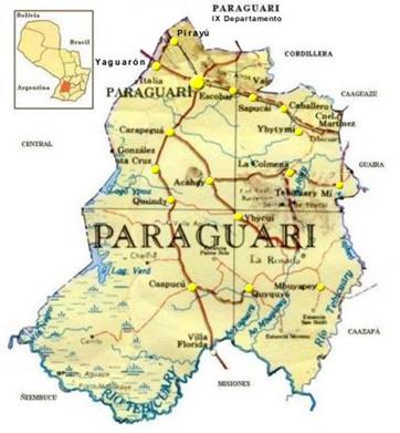
- Paraguarí
infobox city
name = Paraguarí
official_name = Paraguarí
department = Paraguarí
image_
map_size = 200px
subdivision_type = Country
subdivision_name =Paraguay
subdivision_type1 = Department
subdivision_name1 = Paraguarí
leader_title = Intendente Municipal
leader_name = Juan Carlos Baruja Fernandez
country = Paraguay
elevation_m = 87
distance =66
established_title = Founded
established_date =August 18 1775
founder =Agustín Fernando de Pinedo
population_as_of = 2008
population_total = 22,154
area_total_km2 = 273
population_density_km2 = 81
postal_code_type = Postal code
postal_code = 4000
area_code = (595) (531)
web =
latd = 25 | latm = 38 | lats = 0 | latNS = S
longd = 57 | longm = 9 | long = 0 | longEW = WCity of
Paraguay , capital of theParaguarí Department (homonymous), 66 km away from the country’s capital city (Asunción).Toponymy
Paraguarí is called “The cradle of the National Independence”. In that city on
January 13th ,1811 , the Paraguayans Yegros, Gamarra and Cabañas, with their troops, defeated theArgentine Army , commanded by the General Manuel Belgrano in the battle of Cerro Mbaé, securing this way the independence ofParaguay .Was founded in
1775 over a hill byAgustín Fernando de Pinedo , a time after the banishment of theJesuits inParaguay . InAugust 18th ,1960 the town became a district.Geography
The city of Paraguarí is situated to 66 km of
Asunción , bordering to the north with the Altos Cordillera and to the south with a wide savanna.It’s surrounded by the hills Saint Thomas, Cerro Peró (Bald Hill) and Cerro Porteño.
Limits
* To the north: City of
Pirayú .
* To the east:Escobar .
* To the south:Sapucaí ,Acahay andCarapeguá .
* To the west:Yaguarón .Weather
The average temperature is of 21 degrees Celsius, the maximum in summer is 39 degrees Celsius and the minimum in winter is 2 degrees Celsius.
Demography
Paraguarí has 22.154 habitants, from which 11.053 are males and 11.101 females, according to the 2002 census.
In the urban area are 8.307 habitants and in the rural area are 13.847.
Economy
The expansion of the agriculture and livestock industry of the region and an important road network makes of Paraguarí the main supplier of Asunción.
It’s a commercial center for the agriculture products of its inhabitants. Also is an important learning center in the region.
There exist also quarries from which granite and kaolin are extracted.
Transportation
Paraguarí is 66 km away from
Asunción following the Route 1 “Mariscal Francisco Solano López”.To get to Paraguarí you can take an inter-urban bus at the Bus Terminal ofAsunción , or at the Eusebio Ayala Road where about every 15 minutes you’ll find a bus line with destination to Paraguarí.Coming from the east following the Route 2 you must take the Rogelio Benítez Road (7th km) after crossing the detour to Eusebio Ayala.
History
Was founded by Agustín Fernando de Pinedo, ordered by Charles the Third, Kind of Spain, after the banishment of the Jesuits in Paraguay, where he overtook their properties: The ranches “Tavapy” and “Campo Grande”.
Many Spanish people moved to Paraguarí coming from Burgos and Andalucía.
The Company of Jesus in the 7th century established in Paraguarí, in a great ranch until the banishment by the King Charles the Third.
Tourism
The fruit stores of Paraguarí are really famous and concurred. All of them are located to a side of the Route 1.
At the patron’s celebrations of Saint Thomas bullfights are organized (“toro moñaroha” in Guaraní language), besides of the procession, in which the whole city participates.
The route that connects Paraguarí and
Piribebuy is one of the prettiest of the country because it connects also diverse tourist locations that conjugates a unique landscape hills and brooks only a few miles away fromAsunción .One of them is the Mbatovi reservation, located 72 km away from Asunción following the road that connects the Routes 1 and 2, the roadhouses of Chololó, Pinamar, Piraretá and others.
The Museum of Artillery is located at the city and it’s the seat of the Army’s Artillery Command, where are showed cannons and other historical weapons, trophies, photographs and documents.
The neighborhood that testifies the existence of black slaves in the Missiones is Kamba Kokué.
The train station of the city is one of the oldest of America.
The church and many old houses are really attractive to the tourists.
References
*Geografía Ilustrada del Paraguay, Distribuidora Arami SRL; 2007. ISBN 99925-68-04-6
*Geografía del Paraguay, Primera Edición 1999, Editorial Hispana Paraguay SRL
* EVP - Wikipedia
* [http://www.evp.edu.py/index.php?title=Portada Enciclopedia Virtual Paraguaya - Portal]External links
* [http://www.senatur.gov.py/ Secretaria Nacional de Turismo]
* [http://www.dgeec.gov.py// Dirección General de Encuestas, Estadísticas y Censos]
* [http://www.fallingrain.com/world/PA/15/Paraguari.html Coordenadas Geográficas e Imágenes Satelitales: Paraguarí]
* [http://usuarios.lycos.es/viajesyvacaciones/informacion/America/sur/paraguay/departamento_de_paraguari.htm Departamento de Paraguarí]
* [http://www.abc.com.py/paraguay/IXparaguari.htm ABC Color, Así es nuestro país]
* [http://www.bvp.org.py/ Asociación Biblioteca Virtual del Paraguay]


Wikimedia Foundation. 2010.