- Old Leake railway station
-
Old Leake 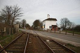
Station in 2007 Location Place Old Leake Area Boston Coordinates 53°03′15″N 0°03′07″E / 53.0542°N 0.0519°ECoordinates: 53°03′15″N 0°03′07″E / 53.0542°N 0.0519°E Operations Original company East Lincolnshire Railway Pre-grouping Great Northern Railway Post-grouping London and North Eastern Railway
Eastern Region of British RailwaysPlatforms 2 History 2 October 1848 Opened as Hob Hole November 1848 Renamed Leake and Wrangle 1 October 1849 Renamed Old Leake and Wrangle October 1852 Renamed Old Leake 17 September 1956 Closed to passenger traffic 15 June 1964 Closed to goods traffic Disused railway stations in the United Kingdom Closed railway stations in Britain
A B C D–F G H–J K–L M–O P–R S T–V W–ZOld Leake was a railway station on the East Lincolnshire Railway[1] which served the village of Old Leake in Lincolnshire between 1848 and 1964. It originally opened as Hob Hole and was renamed three times within the first five years of opening. Withdrawal of passenger services took place in 1956, followed by goods facilities in 1964. The line through the station remains in use as the Poacher Line.
Contents
History
The station was opened on 2 October 1848 as Hob Hole,[2] but was renamed one month later as Leake and Wrangle.[3] The name changed again less than one year later in October 1849 to Old Leake and Wrangle,[4] before becoming simply Old Leake in October 1852.[4] The village of Old Leake lay to the east of the line, whilst Wrangle is 1½ miles to the north-west.[5] The station was constructed by Peto and Betts civil engineering contractors who, in January 1848, had taken over the contract to construct the section of the East Lincolnshire Railway between Louth and Boston from John Waring and Sons.[6] This section was the last to be completed in September 1848 at an agreed cost of £123,000 (£9.62 million as of 2011[7]).[6] At the time, Old Leake village consisted of little more than an inn and the station itself.[5] The July 1922 timetable saw five up and four down services, and one Sunday service each way, call at Old Leake.[8] The station was closed to passengers on 17 September 1956[4] and to goods traffic on 15 June 1964.[9]
Preceding station Historical railways Following station East Ville
Line open, station closedGreat Northern Railway
East Lincolnshire LineSibsey
Line open, station closedPresent day
The line through the station continues to be used by services on the Poacher Line between Grantham and Skegness.
References
- ^ Conolly 2004, p. 17, section C3.
- ^ Butt 1995, p. 121.
- ^ Butt 1995, p. 140.
- ^ a b c Butt 1995, p. 177.
- ^ a b Ludlam 1991, p. 49.
- ^ a b Ludlam 1991, p. 14.
- ^ UK CPI inflation numbers based on data available from Lawrence H. Officer (2010) "What Were the UK Earnings and Prices Then?" MeasuringWorth.
- ^ Ludlam 1991, pp. 111-112.
- ^ Clinker 1978, p. 104.
Sources
- Butt, R. V. J. (1995). The Directory of Railway Stations: details every public and private passenger station, halt, platform and stopping place, past and present (1st ed.). Sparkford: Patrick Stephens Ltd. ISBN 1-8526-0508-1. OCLC 60251199.
- Clinker, C.R. (October 1978). Clinker's Register of Closed Passenger Stations and Goods Depots in England, Scotland and Wales 1830-1977. Bristol: Avon-Anglia Publications & Services. ISBN 0-90546-619-5.
- Ludlam, A.J. (1991). The East Lincolnshire Railway (Locomotive Papers No. 82). Headington, Oxford: The Oakwood Press. ISBN 0-85361-416-4.
- Philip Conolly, W. (2004) [1958]. British Railways Pre-Grouping Atlas and Gazetteer. Hersham, Surrey: Ian Allan Ltd. ISBN 978-0-7110-0320-0.
External links
- Old Leake station on navigable 1947 O. S. map
- Webpage including a picture of Old Leake station building
Categories:- Disused railway stations in Lincolnshire
- Railway stations closed in 1964
- Railway stations opened in 1848
- Former Great Northern Railway stations
- East Midlands railway station stubs

Wikimedia Foundation. 2010.