- Sogod, Southern Leyte
Infobox Settlement
official_name = The Municipality of Sogod
other_name =
native_name = "Lungsod sa Sogod"
nickname =
settlement_type =
motto =
image_caption =
flag_size =
image_
seal_size =
image_shield =
shield_size =
city_
citylogo_size =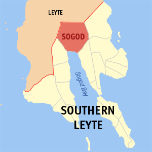
mapsize =
map_caption = Map ofSouthern Leyte showing the location of Sogod.
mapsize1 =
map_caption1 =
pushpin_
pushpin_label_position =
pushpin_map_caption =
pushpin_mapsize =
subdivision_type = Country
subdivision_name =Philippines
subdivision_type1 = Region
subdivision_name1 =Eastern Visayas (Region VIII)
subdivision_type2 = Province
subdivision_name2 =Southern Leyte
subdivision_type3 = Districts
subdivision_name3 =Legislative district of Southern Leyte
subdivision_type4 =Barangays
subdivision_name4 = 45 Barangays
subdivision_type5 =
subdivision_name5 =
government_type =
leader_title = Mayor
leader_name = Shefferd Lino Tan
leader_title1 =
leader_name1 =
established_title =
established_date =
established_title2
established_date2 =
established_title3 =
established_date3 =
area_magnitude =
unit_pref =
area_footnotes =
area_total_km2 =
area_land_km2 =
area_water_km2 =
area_total_sq_mi =
area_land_sq_mi =
area_water_sq_mi =
area_water_percent =
area_urban_km2 =
area_urban_sq_mi =
area_metro_km2 =
area_metro_sq_mi =
population_as_of = 2007
population_footnotes =
population_note =
population_total = 39,864
population_density_km2 =
timezone = PST
utc_offset = +8
postal_code_type = ZIP code
postal_code = 6606
area_code = 53Sogod is a 3rd class municipality in the province of Southern Leyte,
Philippines . According to the2007 census, it has a population of 39,864.The municipality of Sogod is the home of
Southern Leyte State University . Parts of the municipality are prone tomudslides . Following the2006 Southern Leyte mudslide , Governor Lerias placed the town of Sogod under a state of calamity.Within the bay, Sogod town is the centre for trade, commerce and industry. [ [http://72.14.235.104/search?q=cache:Zo-Ofyxn_QAJ:www.coralcay.org/science/publications/philippines_m_2004_leyte_annual.pdf+southern+leyte+climate&hl=tl&ct=clnk&cd=2&gl=ph Coralcay.org] ]
Town History
Early discovery
In
1853 , before it officially became a municipality, Sogod was already a trading center in the Southern Leyte. Natives of the then Sugut village found a settlement in the enclaves of Seilani (now Southern Leyte) near the banks of theSubangdaku River in what the Spaniards later named Baluarte which has retained its name until the present day. In1543 , during era of Villalobos expedition, folks living inAbuyog informed the navigators that a certain area in the southeastern part of the island lies a village named Sugut where Chinese junks are regularly traded the natives with gold. The information was later confirmed when Legazpi expedition in1565 came to visit the country. Seventeen years later, the Spanish chronicler Loarca noted the Sugut was one of the aboriginal villages ofLeyte together with Cabalian (now San Juan),Ormoc andCarigara . [ [http://www.otopphilippines.gov.ph/microsite.aspx?rid=9&provid=16&prodid=465&sec=2 One Town One Product - OTOP Philippines ] ] OnSeptember 6 ,1571 , Sogod became a part of the Spanish encomienda in Leyte.New munipality
In 1616, Sogod was founded as mission by the Jesuits. [ [http://www.admu.edu.ph/offices/mirlab/panublion/r8_leytesouth.html#sogod Southern Leyte ] ] By virtue of a decree signed by Governor General Antonio de Urbiztondo, Sogod became a municipality on
June 10 ,1853 . OnAugust 8 ,1869 , thirteen year after its inauguration, Sogod was raised with a parish status under the patronage of Our Lady of Immaculate Conception by virtue of a Real Aprobacion, an episcopal decree datedMay 14 ,1866 . [ [http://www.southernleyte.ph/index.php?option=com_content&task=view&id=287&Itemid=66 The Official Website of the Provincial Government Of Southern Leyte - Sogod ] ]Barangays
Sogod is politically subdivided into 45
barangay s.
* Benit
* Buac Daku
* Buac Gamay
* Cabadbaran
* Concepcion
* Consolacion
* Dagsa
* Hibod-hibod
* Hindangan
* Hipantag
* Javier
* Kahupian
* Kanangkaan
* Kauswagan
* La Purisima Concepcion
* Libas
* Lum-an
* Mabicay
* Mac
* Magatas
* Mahayahay
* Malinao
* Maria Plana
* Milagroso
* Olisihan
* Pancho Villa
* Pandan
* Zone I (Pob.)
* Zone II (Pob.)
* Zone III (Pob.)
* Zone IV (Pob.)
* Zone V (Pob.)
* Rizal
* Salvacion
* San Francisco Mabuhay
* San Isidro
* San Jose
* San Juan (Agata)
* San Miguel
* San Pedro
* San Roque
* San Vicente
* Santa Maria
* Suba
* TampoongGeography
Sogod is bounded in the north by
Mahaplag, Leyte , in the south bySogod Bay , in the east byLibagon and in the west byBontoc . It has a totalland area of 19,270 hectares. The town has mostly plains and hills and mountainous areas in the deep northern-northwestern and northearstern parts.References
External links
* [http://www.nscb.gov.ph/activestats/psgc/default.asp Philippine Standard Geographic Code]
* [http://www.t-macs.com/kiso/local/ 2000 Philippine Census Information]
Wikimedia Foundation. 2010.