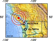
1946 Vancouver Island earthquake
- 1946 Vancouver Island earthquake
Earthquake
title = 1946 Vancouver Island earthquake
date = June 23, 1946

magnitude = 7.3 Mw
depth = approx. Unit km|20|0
location = coord|49.75|N|124.5|W
countries affected = Canada
tsunami =
aftershocks =
casualties = 2 killed
The 1946 Vancouver Island earthquake was a 7.3 magnitude earthquake that struck Vancouver Island on the coast of British Columbia, Canada at 10:15 a.m. on Sunday, June 23, 1946.
This earthquake is Canada's largest historic onshore earthquake.[ [http://earthquakescanada.nrcan.gc.ca/historic_eq/20th/1946/1946_e.php The M7.3 Vancouver Island Earthquake of 1946] Retrieved on 2008-06-11] However, the greatest earthquake in Canadian history recorded by seismometers was the 1949 Queen Charlotte earthquake, a interplate earthquake that occurred along in the ocean bottom just offshore the rugged coast of Graham Island which reached magnitude 8.1 on the moment magnitude scale. [ [http://earthquakescanada.nrcan.gc.ca/historic_eq/20th/1949_e.php The Magnitude 8.1 Queen Charlotte Island Earthquake of Augest 22, 1949] Retrieved on 2008-06-11] ]ee also
*List of earthquakes in Canada
*1949 Queen Charlotte earthquake
References
Wikimedia Foundation.
2010.
Look at other dictionaries:
Vancouver Island — Infobox Islands name = Vancouver Island image caption = image size = locator Location map|Canada British Columbia|lat=49.798287|long= 126.123047|marksize=16 map custom = yes native name = native name link = nickname = location = Pacific Ocean… … Wikipedia
1946 — This article is about the year 1946. Millennium: 2nd millennium Centuries: 19th century – 20th century – 21st century Decades: 1910s 1920s 1930s – 1940s – 1950s … Wikipedia
Submarine earthquake — A submarine earthquake is an earthquake which occurs underwater at the bed of the sea. They can produce tsunamis, also known as harbor waves or tidal waves . The magnitude can be measured scientifically by the use of either the Richter scale or… … Wikipedia
Forbidden Plateau — The Forbidden Plateau is a small, hilly plateau in the east of the Vancouver Island Ranges in British Columbia, located roughly between Mount Albert Edward to the southwest and Mount Washington (site of the Mount Washington Alpine Resort) to the… … Wikipedia
List of earthquakes in Canada — This is a list of earthquakes in Canada:*1663 Charlevoix earthquake *1700 Cascadia earthquake *1732 Montreal earthquake *1791 Charlevoix earthquake *1860 Charlevoix earthquake *1870 Charlevoix earthquake *1872 Washington earthquake *1918… … Wikipedia
Strait of Georgia — The Strait of Georgia or the Georgia Strait [http://ilmbwww.gov.bc.ca/bcgn bin/bcg10?name=6050] (also known as the Gulf of Georgia), is a strait between Vancouver Island (as well as its nearby Gulf Islands) and the mainland Pacific coast of… … Wikipedia
Deep Bay, British Columbia — Aerial view of Deep Bay Marina with Baynes Sound, Denman Island (Chrome Island Light off its tip) and Hornby Island in the background. Deep Bay is an unincorporated area on the east coast of Vancouver Island, in British Columbia, Canada across… … Wikipedia
Courtenay, British Columbia — City of Courtenay Coat of arms of City of Courtenay Coat of arms … Wikipedia
Cumberland, British Columbia — For other places with the same name, see Cumberland (disambiguation). Town of Cumberland Town … Wikipedia
Earth Sciences — ▪ 2009 Introduction Geology and Geochemistry The theme of the 33rd International Geological Congress, which was held in Norway in August 2008, was “Earth System Science: Foundation for Sustainable Development.” It was attended by nearly… … Universalium

