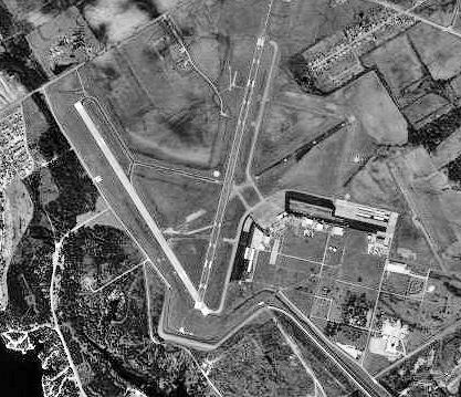
- Waco Regional Airport
:"For the radio stations in Andrews, Texas, see
KACT (AM) andKACT-FM ."Infobox Airport
name = Waco Regional Airport

IATA = ACT
ICAO = KACT
FAA = ACT
type = Public
owner = City of Waco
operator =
city-served =Waco, Texas
location =
elevation-f = 516
elevation-m = 157
website = [http://waco-texas.com/airport/airport.htm waco-texas.com/airport/...]
r1-number = 1/19
r1-length-f = 6,596
r1-length-m = 2,010
r1-surface =Asphalt
r2-number = 14/32
r2-length-f = 5,896
r2-length-m = 1,797
r2-surface = Asphalt
stat-year = 2006
stat1-header = Aircraft operations
stat1-data = 36,011
stat2-header = Based aircraft
stat2-data = 100
footnotes = Source:Federal Aviation Administration FAA-airport|ID=ACT|use=PU|own=PU|site=24976.*A, effective 2007-10-25]Waco Regional Airport Airport codes|ACT|KACT|ACT is a public
airport located five miles (8 km) northwest of thecentral business district of Waco, a city in McLennan County,Texas ,United States . It is owned by the City of Waco.The airport is a 20-25 minute drive by street to Downtown Waco and the Baylor University Campus.
Facilities and aircraft
Waco Regional Airport covers an area of 1,369
acre s (554 ha) which contains twoasphalt pavedrunway s: 1/19 measuring 6,596 x 150 ft (2,010 x 46 m) and 14/32 measuring 5,896 x 150 ft (1,797 x 46 m).For the 12-month period ending December 31, 2006, the airport had 36,011 aircraft operations, an average of 98 per day: 65%
general aviation , 27%air taxi , 8% military and 1% scheduled commercial. There are 100 aircraft based at this airport: 53% single-engine, 38% multi-engine, 6% jet and 3%helicopter .The airport is currently planning for an expansion which would create three jetways, along with a larger lobby area and holding room. There is no wireless access at the airport; although, it is planned in the expansion.
Airlines and destionations
*
American Airlines
** American Eagle (Dallas/Fort Worth)
*Continental Airlines
**Continental Connection operated byColgan Air (Houston-Intercontinental)References
See also
*
TSTC Waco Airport
*Texas World War II Army Airfields External links
* [http://waco-texas.com/airport/airport.htm Waco Regional Airport] , official site
*WikiMapia|31.6113|-97.2305|14|Aerial photo
*US-airport|ACT
Wikimedia Foundation. 2010.
