Dalrymple, East Ayrshire

Dalrymple, East Ayrshire
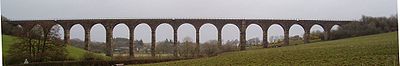
Dalrymple Railway Viaduct to the north of the village

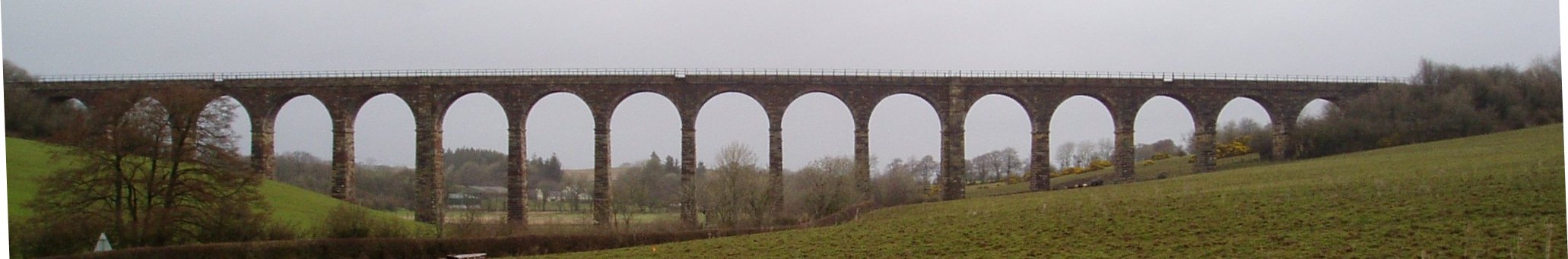
Dalrymple is a village in East Ayrshire, Scotland. It is at the western-most point of East Ayrshire, around 8km south-east of Ayr. Dalrymple is in the Doon Valley, on the north bank of the River Doon. The population is 1,347.[1]

The name Dalrymple derives from the Scottish Gaelic language, meaning "flat field of the crooked pool or river".[1] The village is relatively modern, although the parish and church of Dalrymple are older. When the community was first established around 1800, there were two streets, Main Street and Garden Street. The village grew slowly until the late 20th century, when council housing was erected to house families from coal-mining villages in the area that were suffering an economic decline.

It has approximately 1,000 houses. There are two pubs, the Kirkton Inn and the more popular White Horse, as well as two shop and a postal office come shop. The village is in the catchment area for high schools in Ayr, Maybole and Dalmellington. The town of Ayr is about seven miles north of Dalrymple, and buses to and from Ayr run every hour.

See also

  1. Martnaham Loch

References

  1. ^ a b "Dalrymple". East Ayrshire Council. http://www.east-ayrshire.gov.uk/comser/my%20area/dalrymple.asp. Retrieved 2008-06-04. 

Coordinates: 55°23′50.96″N 4°35′9.72″W / 55.3974889°N 4.5860333°W / 55.3974889; -4.5860333


Wikimedia Foundation. 2010.

Игры ⚽ Поможем сделать НИР

Look at other dictionaries:

  • East Ayrshire — Siorrachd Inbhir Àir an Ear Verwaltungssitz Kilmarnock Fläche …   Deutsch Wikipedia

  • East Ayrshire — Géographie Superficie 14e Total 1262 km²  % eau ? Capitale administrat …   Wikipédia en Français

  • East Ayrshire — infobox Scotland council area Council= Shire of East Ayrshire |250px SizeRank= 14th Size= 1,262 km² Water= ? AdminHQ= Kilmarnock ISO= GB EAY ONS= 00QK PopulationRank= 16th PopulationDate= 2001 Population= 120,235 PopulationDensity=95 / km²… …   Wikipedia

  • List of places in East Ayrshire — This List of places in East Ayrshire is a list of links for any town, village, hamlet, castle, golf course, historic house, nature reserve, reservoir, river and other place of interest in East Ayrshire.compactTOC NOTOC A*Afton Bridgend… …   Wikipedia

  • Stair, East Ayrshire — The hamlet of Stair in Scotland nestles at the bottom of a glen beside the River Ayr at the north west border of the 5,376 acre (22 km²) parish of Stair where the River Ayr is joined by Trabboch Burn in what is now known as East Ayrshire.In the… …   Wikipedia

  • Dalrymple railway station — Dalrymple The site of Dalrymple in 2008 Location Place Dalrymple …   Wikipedia

  • Dalrymple — For persons named Dalrymple (given name or surname), see Dalrymple (name). Dalrymple may refer to: HMS Dalrymple (K427), frigate of the British Royal Navy Dalrymple s sign, a medical condition of the eyes associated with goitre Places Dalrymple,… …   Wikipedia

  • Dalrymple — ist der Name folgender Orte: Dalrymple (Ayrshire), Ort in der Grafschaft East Ayrshire in Schottland Dalrymple ist der Name folgender Personen: Alexander Dalrymple (1737–1808), schottischer Geograph Dolly Dalrymple (1808–1864), erstes Halbblut ,… …   Deutsch Wikipedia

  • Ayrshire — This article is about the region in Scotland. For the cattle originating from Ayrshire, see Ayrshire cattle. For the small city in the United States, see Ayrshire, Iowa. Ayr   County (until circa 1890)   …   Wikipedia

  • Ayrshire (comté) — 55°30′N 4°30′W / 55.5, 4.5 …   Wikipédia en Français

Share the article and excerpts

Direct link
Do a right-click on the link above
and select “Copy Link”