Tullaghan

Tullaghan

Infobox Irish Place
name = Tullaghan
gaeilge = An Tulachán
crest

motto =
map

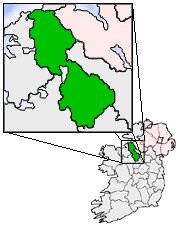
pin coords = left: 34px; top: 7px
north coord = 54.4683 | west coord = 8.3311 | irish grid = G785578
area = | elevation = 1 m
province = Connacht
county = County Leitrim
population = | town pop = - | rural pop = 520
census yr = 2002
web = |

Tullaghan ( _ga. An Tulachán) is a village in County Leitrim, Ireland. Due to unrestrained property development, fuelled by tax breaks, it has now mushroomed in size and is effectively a suburb of Bundoran - a holiday resort in the neighbouring County Donegal.

It is the northmost village in Leitrim. It's situated on the 3 km coastline of County Leitrim, on the N15 between Sligo, County Sligo (35 km) and Bundoran, County Donegal (3 km). The river Drowes denotes the border between County Leitrim and County Donegal and the River Duff denotes the border between County Leitrim and County Sligo.

ee also

* List of towns in the Republic of Ireland


Wikimedia Foundation. 2010.

Игры ⚽ Поможем решить контрольную работу

Look at other dictionaries:

  • Tullaghan — Administration Nom irlandais An Tulachán Pays Irlande Province Connacht Comté Comté de Leitrim Démographie …   Wikipédia en Français

  • County Leitrim — Contae Liatroma Coat of arms …   Wikipedia

  • Coastal landforms of Ireland — Ireland is an island surrounded by water,[1] with a 7,500 kilometre coastline.[2] This list catalogues about 400 of the coastal landforms of the island including bays, estuaries, harbours, headlands, and many others.[3][4][5] Most offshore… …   Wikipedia

  • Atlantic Seafront B&B — (Tullaghan,Ирландия) Категория отеля: Адрес: Shore Road, Wardhouse, Tullagha …   Каталог отелей

  • Donegal Bay — (Bá Dhún na nGall in Irish) is an inlet (or bay) in the northwest of Ireland. Three counties – Donegal to the north and west, Leitrim and Sligo to the south – have shorelines on the bay, which is bounded on the west by the Atlantic Ocean. The… …   Wikipedia

  • N15 road (Ireland) — N15 road Location Primary destinations: (bypassed routes in italics) County Donegal Lifford* Castlefin* Killygordo …   Wikipedia

  • Bahía de Donegal — Saltar a navegación, búsqueda 54°32′N 8°30′O / 54.533, 8.5 …   Wikipedia Español

  • Donegal Bay — 54.533333333333 8.5 Koordinaten: 54° 32′ 0″ N, 8° 30′ 0″ W …   Deutsch Wikipedia

  • Таллахан — Деревня Ирландии Таллахан англ. Tullaghan, ирл. An Tulachán Страна И …   Википедия

  • Manorhamilton — Cluainín   Town   …   Wikipedia

Share the article and excerpts

Direct link
Do a right-click on the link above
and select “Copy Link”