- 40 Mile Loop
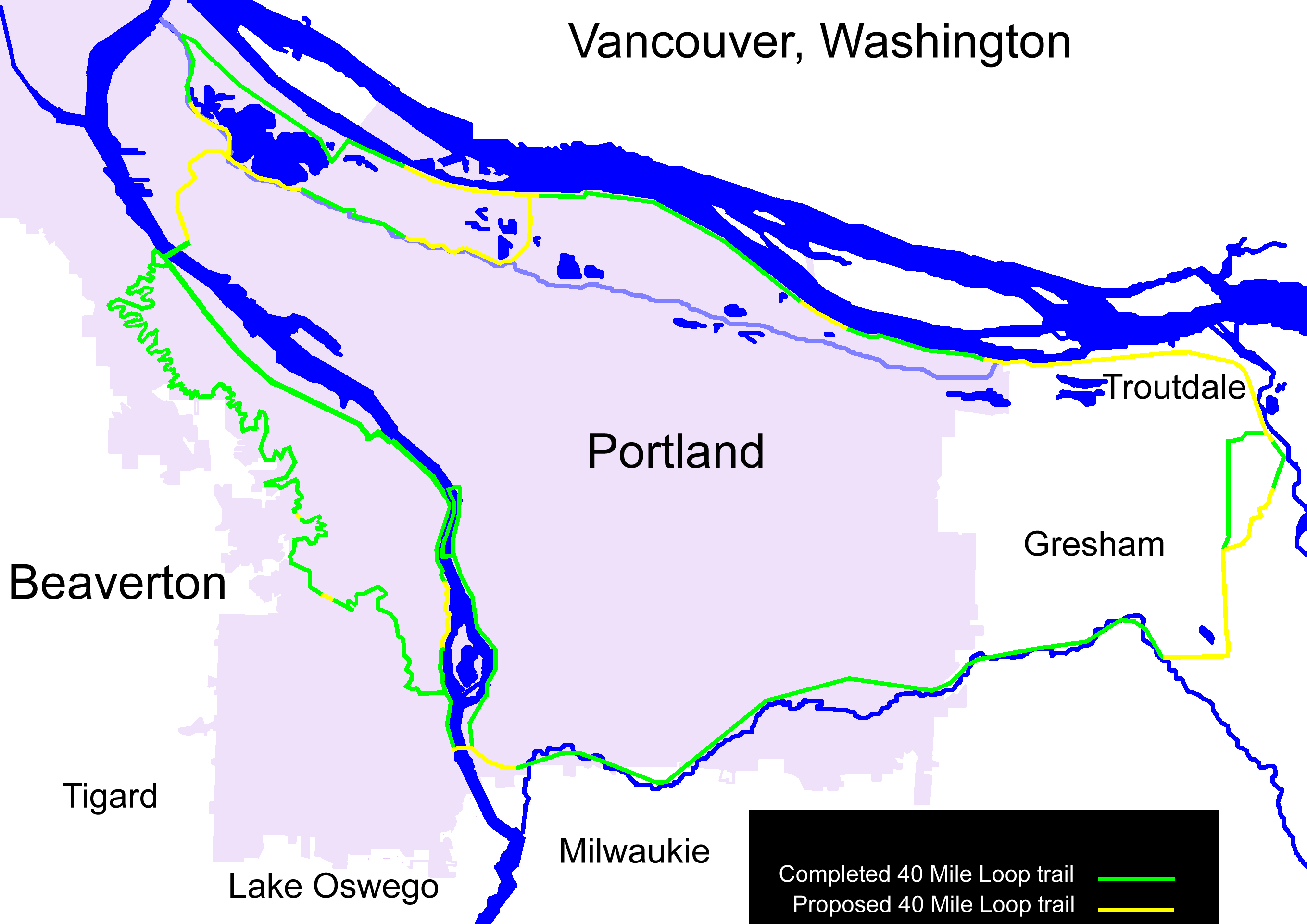
350px|thumb| Map of the 40 Mile Loop">legend|lightgreen|Completed traillegend|yellow|Proposed trailThe 40 Mile Loop is a partially completed greenway trail around and through Portland in the
U.S. State ofOregon . It was proposed in 1903 [ Sources disagree over the date of the park loop proposal: some give 1903, some 1904.] by the highly-regardedOlmsted Brothers architecture firm as part of the development of Forest Park. cite web
title = Forest Park
publisher = Portland Parks and Recreation Department, City of Portland
date = 2008
url = http://www.portlandonline.com/parks/finder/index.cfm?PropertyID=127&action=ViewPark
accessdate = 2008-05-30 ] cite web
url = http://www.40mileloop.org/history.htm
title = 40 Mile Loop history
work = 40-Mile Loop Land Trust
accessdate = 2008-05-30 ] One greenway expert calls it "one of the most creative and resourceful greenway projects in the country." cite book
url = http://books.google.com/books?id=qhPzEmNKE8EC&pg=PA76&lpg=PA76&dq=40+Mile+Loop&source=web&ots=qVaqz0Bat6&sig=YrE6Knd_4JHEUv_0gknn_ZbdQQQ&hl=en#PPA76,M1
title = Greenways for America
author = Charles E. Little
date = 1990
publisher = JHU Press
id = ISBN 0801851408
pages = 76–80
accessdate = 2008-05-30 ]The name's "forty" was obsolete within a few decades after it was proposed. The proposed total path is now about convert|140|mi|km long, and connects more than thirty city parks. Similarly, "loop" is not entirely accurate. There are several subloops, cutoffs and spur trails within the system. One spur is proposed to connect to the
Pacific Crest Trail . cite web
url = http://www.40mileloop.org/maps/40MileLoop_map.pdf
title = 40 Mile Loop map
format = pdf
work = 40-Mile Loop Land Trust
accessdate = 2008-07-10 ]History
As part of beautification planning for the
Lewis and Clark Centennial Exposition of 1905, the city of Portland invited theOlmsted Brothers in 1903. Besides suggestions for Washington Park, their research of existing city parks resulted in a bold proposal for a loop of interconnected parks around the city, instead of a traditional plan of scattered parks: "A connected system of parks and parkways is manifestly far more complete and useful than a series of isolated parks." As the brothers puzzled over a name for the system, one asked the other "What would you call a forty-mile loop?" The firm was famous for its straightforward names, so they left it at that.Little action occurred until a $1 million city bond measure in 1907 passed, which was used to develop existing parks. In 1912, another city planner,
Edward H. Bennett , also recommended developing a ridgetop park long the West Hills. A $2 millionbond issue to acquire the necessary land was voted down. However, shortly afterward, most of the lots sold in Forest Park forfeited to the city or Multnomah County due to high assessments for road building, and a landslide.In 1943, influential urban planner
Robert Moses was hired, and recommended establishing Forest Park. After several subsequent years of controversy, the park was created in 1948 from tax-delinquent lands, gifts, and purchases. This contained the first portion of the 40 mile loop.Little more happened until 1978: at the request of Oregon legislators, U.S. Congress stripped the
Columbia Slough of its "navigable" status, enabling the land to be dedicated to recreational use, an important component of the Olmsted plan. The Oregon director of theNature Conservancy responded to withering federal funds for parks and natural areas by reviving the loop plan to enthusiastic receptions by the City, suburban cities, federal agencies, conservationists, and civic groups. The alliance eventually formed the "40-Mile Loop Land Trust" which proved most effective at getting the thirteen key governmental entities—which normally did not talk to each other—to effectively work together. It also served as an intermediary to transfer property from one entity to the other.One of the Land Trust's major victories was bringing
Southern Pacific andUnion Pacific railroads together, which jointly owned the abandonedSpringwater Corridor , to transfer the land in 1990 to the Trust. It represented significant progress in the completion of the loop.Trail
The trail has a variety of sections: some are on level ground, such as along the
Columbia River ; others are heavily forested and/or mountainous, as through Washington Park'sHoyt Arboretum . All portions are suitable for walking and hiking, and most are open to bicycling. There are opportunities for strollers, wheelchairs, skating, skateboarding, horseback riding, canoeing, and kayaking.Route
Highlights
*
St. Johns Bridge
*Kelley Point Park
* N. and NE Marine Drive along the south bank of theColumbia River
*Smith Lake (Portland, Oregon)
*Bybee Lake
*Columbia Slough
*Blue Lake Park
*Troutdale, Oregon
*Mount Hood Community College
*Gresham, Oregon
*Springwater Corridor
**Gresham Main City Park
**Gresham Butte
**Powell Butte Nature Park
**Leach Botanical Garden
**I-205 Bike Path
**Tideman-Johnson Park
**Sellwood Park
**Sellwood Riverfront Park
**Oaks Amusement Park
**Oaks Bottom Wildlife Refuge
**Eastbank Esplanade
**Hawthorne Bridge
**Steel Bridge
*Sellwood Bridge
*Willamette Greenway Trail
**Willamette Park
**South Waterfront
*Wildwood Trail
** Washington Park
***Hoyt Arboretum
**Pittock Mansion
** Forest Park
**Audubon Society of Portland See also
*
Mount Tabor, Portland, Oregon , another park included in the Olmsted planReferences
Wikimedia Foundation. 2010.