- Navigational Algorithms
-
Navigational Algorithms is a source of information whose purpose is to make available the scientific part of the art of navigation, containing specialized articles and software that implements the various procedures of calculus. The topics covered are:
- Celestial navigation: Sight Reduction, Line Of Position, Fix...
- Positional astronomy: RA, GHA, Dec
- Coastal navigation: Range, Bearing, Horizontal angles, IALA...
- Sailings: Rhumbs, Loxodromic, Orthodromic, Meridional parts...
- Weather, tides
- Software PC- PDA: Nautical Almanac, Sailings, Variation, Sextant corrections
Contents
Include articles about piloting and astronavigation: Corrections for sextant altitude, Sight Reduction with calculator-Form & Plotting sheet for celestial LoPs, Celestial Fix - 2 LoPs, Celestial Fix - n LoPs NA Sight Reduction algorithm, Vector equation of the Circle of Position, Vector Solution for the intersection of two Circles of Equal Altitude, Sight Reduction - Matrix solution.
Include papers about introduction to navigation, tides, naval kinematics, weather and oceanography
This section gives a brief description of the free programs available for navigation. Run under Windows XP, (maybe under 95/98/2000/NT)
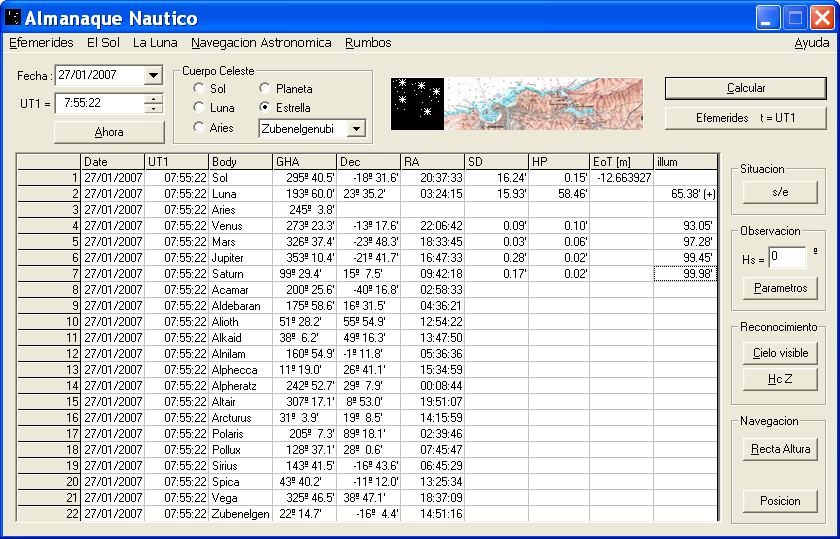
Nautical Almanac
Ephemerides of the celestial bodies used in navigation.
 Nautical Almanac
- GHA - Greenwich Hour Angle
- Dec - Declination
- SD - Semidiameter
- HP - Horizontal Parallax
CelestialFix
Astronavigation solution for sight reduction for n observations made with a marine sextant & running fixes
The algorithms implemented are: For n = 2 observations- An analytical solution of the two star sight problem of celestial navigation, James A. Van Allen[1].
- Vector Solution for the Intersection of two Circles of Equal Altitude. Andrés Ruiz[2].
For n ≥ 2 observations
- DeWit/USNO Nautical Almanac/Compac Data, Least squares algorithm for n LOPs
- Kaplan algorithm, USNO[3]. For n ≥ 8 observations, gives the solution for course and SOG.
Magnetic declination
Any measure of course made with a magnetic compass must be corrected because of the magnetic declination or local variation.
See also
- Navigation
- Celestial navigation
- Nautical almanac
- Lunar distance (navigation)
- Sextant
- American Practical Navigator
References
- ^ An analytical solution of the two star sight problem of celestial navigation. James A. Van Allen. NAVIGATION Vol. 28, No. 1, 1981
- ^ Vector Solution for the Intersection of Two Circles of Equal Altitude. Andrés Ruiz González. Journal of Navigation, Volume 61, Issue 02, April 2008, pp 355–365.The Royal Institute of Navigation
- ^ Determining the Position and Motion of a Vessel from Celestial Observations, Kaplan, G. H. Navigation, Vol. 42, No. 4, 1995, pp. 631–648
External links
- Navigational Algorithms
- Vector Solution for the Intersection of Two Circles of Equal Altitude, Andrés Ruiz González. Journal of Navigation, Volume 61, Issue 02, April 2008, pp 355–365
- Journal of Navigation http://journals.cambridge.org/action/displayJournal?jid=NAV
- The Institute of Navigation http://www.ion.org/
- Correction to the sextant altitude http://es.wikipedia.org/wiki/Archivo:CorrecionHs.jpg
- Marcq St Hilaire intercept for the line of position http://es.wikipedia.org/wiki/Archivo:MarcqSaintHilaire.jpg
Categories:
Wikimedia Foundation. 2010.