- Kolomyia
-
Kolomyya
КоломияCity Hall in KolomyyaCity Hall in KolomyyaCoat of arms of Kolomyya
Coat of armsLocation of Kolomyya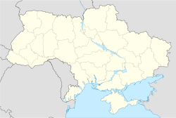
 Kolomyya
Coordinates: 48°31′50″N 25°02′25″E / 48.53056°N 25.04028°ECoordinates: 48°31′50″N 25°02′25″E / 48.53056°N 25.04028°E Country
Oblast
RaionUkraine
Ivano-Frankivsk Oblast
Kolomyya Raion / MunicipalityArea – Total 41 km2 (15.8 sq mi) Population – Total 61,448 – Density 1,509/km2 (3,908.3/sq mi) Website www.ko.if.ua
City's administrative statistics at Verkhovna Rada web-site- For the Ukrainian folk dance named after the city of Kolomyya, see Kolomyjka.
Kolomyia or Kolomyya, formerly known as Kolomea (Ukrainian: Коломия, Polish: Kołomyja, Russian: Коломыя, German: Kolomea, Romanian: Colomeea), is a city located on the Prut River in the Ivano-Frankivsk Oblast (province), in western Ukraine. Serving as the administrative centre of the Kolomyia Raion (district), the city is also designated as a separate raion within the oblast. The city rests approximately halfway between Lviv and Chernivtsi, in the center of the historical region of Pokuttya, with which it shares much of its history.
The current estimated population was around 68,000 inhabitants as of 1993.
The city is a notable railroad hub, as well as an industrial center (textiles, shoes, metallurgical plant, machine works, wood and paper industry). It is a center of Hutsul culture. At the turn of the 20th century the city was the most populous city in Stanislawow voivodeship.
Contents
History
Early history
Under Kievan Rus' and the principality of Halych-Volhynia (1241–1340)
The settlement of Kolomyia was first mentioned in 1241, during the Mongol invasion of Rus. Initially part of Kievan Rus', it later belonged to one of its successor states, the principality of Halych-Volhynia.
Under Poland (1340–1498)
In 1340 it was annexed to Poland by King Casimir III, together with the rest of the region of Red Ruthenia. In a short time the settlement became one of the most notable centres of commerce in the area. Because of that, the population rose rapidly.
Prior to 1353 there were two parishes in the settlement, one for Catholics and the other for Orthodox. In 1412 King Władysław Jagiełło erected a Dominican order monastery and a stone-built church there. About the same time, the king was forced by the war with the Teutonic Order to pawn the area of Pokucie to the hospodar of Moldavia, Alexander. Although the city remained under Polish sovereignty, the income of the customs offices in the area was given to the Moldavians, after which time the debt was repaid.
Development
In 1405 the town's city rights were confirmed and it was granted with the Magdeburg Law, which allowed the burghers limited self-governance.[1][2] This move made the development of the area faster and Kołomyja, as it was called then, attracted many settlers from many parts of Europe. Apart from the local Ukrainians and Poles, many Armenians, Jews, and Hungarians settled there. In 1411 the fortress-city was given away for 25 years to the Vlach Hospodar Olexander as a gift for his support in the war against Hungary.[3] In 1443, a year before his death, King Wladislaus II of Poland granted the city yet another privilege which allowed the burghers to trade salt, one of the most precious minerals of the Middle Ages.
Since the castle gradually fell into disarray, in 1448 King Casimir IV of Poland gave the castle on the hill above the town to Maria, widow of Eliah, voivod of Moldavia as a dowry. In exchange, she refurbished the castle and reinforced it. In 1456 the town was granted yet another privilege. This time the king allowed the town authorities to stop all merchants passing by the town, and force them to sell their goods at the local market. This gave the town an additional boost, especially as the region was one of three salt-producing areas in Poland (the other two being Wieliczka and Bochnia), both not far from Kraków.
The area was relatively peaceful for the next century. However, the vacuum after the decline of the Golden Horde started to be filled by yet another power in the area: the Ottoman Empire. In 1485 Sultan Beyazid II captured Belgorod and Kilia, two ports at the northern shores of the Black Sea. This became a direct threat to Moldavia. In search of allies, its ruler Ştefan cel Mare came to Kołomyja and paid homage to the Polish king, thus becoming a vassal of the Polish Crown. For the ceremony, both monarchs came with roughly 20,000 knights, which was probably the biggest festivity ever held in the town. After the festivity most knights returned home, apart from 3,000 under Jan Karnkowski, who were given to the Moldavian prince as support in his battles, which he won in the end. In 1490 the city was sacked by the riot of Ivan Mukha.[4]
Decline
However, with the death of Stefan of Moldova, the neighbouring state started to experience both internal and external pressure from the Turks. In the effect of border skirmishes, as well as natural disasters, the town was struck by fires in 1502, 1505, 1513, and 1520.
Under Moldova (1498–1531)
Władysław II Jagiełło, needing financial support in his battles against the Teutonic Knights, used the region as a guarantee in a loan which he obtained from Petru I of Moldavia, who thus gained control of Pokuttya in 1388 , therefore, became the feodal property of the princes of Moldavia, but remained within the Kingdom of Poland..
After the Battle of the Cosmin Forest, in 1498, Pokuttia was conquered by Stephen the Great, annexed and retained by Moldavia until the Battle of Obertyn in 1531, when it was recaptured by Poland's hetman Jan Tarnowski, who defeated Stephen's son Petru Rareş. Minor Polish-Moldavian clashes for Pokuttia continued for the next 15 years, until Petru Rareş's death.
Polish – Ottoman wars
The following year hetman Jan Tarnowski recaptured the town, and defeated the Moldavians in the Battle of Obertyn. This victory secured the city's existence for the following years, but the Ottoman power grew and Poland's southern border remained insecure.
In 1540 Jews were allowed to live in Kolomyia with some restrictions.
In 1589, the Turks crossed the border and seized Kołomyja almost immediately. All the burghers taking part in the defence were slaughtered, while the rest were forced to pay high indemnities.
The town was returned to Poland soon afterwards, but the city's growth lost its momentum. In 1616 Jews were permitted to have land to build a synagogue and cemetery.
In 1620, another Polono-Turkish war broke out. After the Polish defeat at Ţuţora, Kołomyja was yet again seized by the Turks – in 1626[5] the town was burned to the ground, while all of residents were enslaved in a jasyr.
After the war the area yet again returned to Poland. With the town in ruins, the starosta of Kamieniec Podolski fortress financed its reconstruction – slightly further away from the Prut River. The town was rebuilt, but never regained its power and remained one of many similar-scaled centres in the area.
In 1648–49, Chmielnick forces killed 300 Jews, nearly the entire community. In 1700 Jews moved back to Kolomea, and by 1765 the Jewish population was 1,072.
Partition of Poland
As a result of the Partitions of Poland of 1772, Kołomyja was annexed by Austria. Austris restricted Jewish trade in lumber and salt, and imposed special taxes on Jews for marriage permits, kosher meat, synagogues, and similar items. Marriage was restricted to the oldest Jewish son, and quotas were placed on number of Jewish families that could reside in Galicia.
In the 1790s, Jews, who had been subjected to conscription to the Austro-Hungarian army, had conscription abolished and replaced by a 30 zloty levy for each Jewish man of military age.
However, as it provided very little profit, Kołomyja was sold to the castellan of Bełz, Ewaryst Kuropatnicki, who became the town's owner. The magnate financed a new Our Lady's Church, but he lacked finance for speeding-up the city's growth.
In 1797 secular education was mandated for Jews. In 1812 the Jewish population was 2,033. In 1814 Jews were prohibited from publishing or importing Hebrew and Yiddish books, and in 1834 the Jews of Austria were forbidden to have first names of Christian saints. In 1860 Jews were finally allowed to own real estate and buy houses.
The prosperity returned to the town in mid-19th century, when it was linked to the world through the Lemberg-Czernowitz railroad. By 1882 the city had almost 24.000 inhabitants, including roughly 12,000 Jews, 6,000 Ruthenians, and 4,000 Poles. Until the end of that century, the commerce attracted even more inhabitants from all-over the Galicia. Moreover, a new Jesuit Catholic church was built in Kolomyja, as it was called by German authorities, along with a Lutheran church built in 1874. By 1901 the number of inhabitants grew to 34,188, approximately half of them Jews.
20th century
In 1900 the Jewish population was 16,568, again nearly 50% of the town’s population. The Jewish community had a Great Synagogue, and about 30 other synagogues. In 1910 Jews were prohibited from selling alcoholic beverages. In 1911 they were prohibited from salt and wine occupations.
After the outbreak of the Great War, the town saw fierce battles between the forces of the Russian Empire and Austria-Hungary. Jews were abused for supposedly supporting the Austrians, and many Jewish homes were ransacked and destroyed.
The Russians advance occupied the town in September 1914.
In 1915 the Austrians retook the town.
As a result of the collapse of Austria-Hungary, both the town itself and the surrounding region became disputed between renascent Poland and the West Ukrainian People's Republic.
Second Polish Republic
However, during the Polish-Ukrainian War of 1919, it was seized without a fight by forces of Romania, and handed over to Polish authorities. During the Polish-Bolshevik 1919 war in Ukraine, a Polish division under General Zeligowski tore through Bessarabia and Bukovina and stopped in Kolomea during its winter march to Poland. Kolomea was then temporarily occupied by the Rumanians and the border was near the shtetl Otynia between Stanislav and Kolomea.
After the Polish-Soviet War it remained in Poland as a capital of a powiat within the Stanisławów Voivodship. By 1931 the number of inhabitants grew to over 41,000. The ethnic mixture was composed of Jews, Poles, Ukrainians, Hutsuls, Germans, Armenians, and Hungarians, as well as of descendants of Valachians and other nationalities of former Austria-Hungary. With the development of infrastructure, the town became a major railroad hub, as well as the garrison city of the 49th Hutsul Rifle Regiment, probably the only purely-Hutsul military unit in history. In the interbellum period, every Thursday a market took place at the main square of the town. The town did not have any monuments other than a monument of Polish poet Franciszek Karpinski, and an obelisk near the town, located in a spot where in 1485 hospodar Stephen III of Moldavia paid tribute to king Kazimierz IV Jagiellon.
After the outbreak of World War II with the Polish Defensive War of 1939, the town was thought of as one of the centers of Polish defense of the so-called Romanian Bridgehead.
Part of Soviet Union and World War II
However, the Soviet invasion from the east made these plans obsolete, and the town was occupied by the Red Army.
As a result of the Molotov-Ribbentrop Pact, the occupied town was anexed by the Soviet Union to the Ukrainian SSR. In 1940 most of the local population were arrested by the NKVD, and sent to Gulag system or to various Soviet prisons among which were Polish, Ukrainians, Hungarians, and many others.
In 1941, the town was seized by Nazi Germany.
During the German occupation most of the city's Jews were murdered by the Germans. Initial street executions of September and October 1941 took the lives of approximately 500 people. The following year the remaining Jews were massed in a local ghetto, and then murdered in various concentration camps, mostly in Bełżec. Several hundred Jews were kept as slave workers in a work camp, and then murdered in 1943 in a forest near Szeparowka.
When the town was liberated by the Red Army the rest of the local population was displaced and replaced with people from the eastern Ukraine or other parts of the Soviet Union.
During the Cold War the town was the headquarters of the 44th Rocket Division of the Strategic Rocket Forces, which had previously been the 73rd Engineer Brigade RVGK at Kamyshin. The division was disbanded on 31 March 1990.[6]
Under the independent Ukraine (1991–present)
It now remains a part of Ukraine, independent since 1991.
It is a twin town of Nysa in Poland, to where many of its former inhabitants were expelled after the war.
Kolomyia administrative district
The Kolomyia raion (administrative district), a historic subdivision of Galicia, was divided into the Kolomyia and Hvizdets sub-districts. It included such towns and shtetls as:
- Lisnyi Khlibychyn (Chiebiczyn Lesny)
- Cheremkhiv (Czeremchow)
- Kolomyia
- Kuty
- Pechenizhyn (Peczenizyn)
- Tiunaczyk
- Local orientation

Rakovchyk
Sheparivtsi
KnyazhdvirLisna Slobidka
Mala KamiankaPyadky Kyidantsi
Nyzhniy Verbizh
Pyadky
Tsenyava Kolomyia

Sopiv
Verkhniy VerbizhSpas
VoskresyntsiKornych
Korolivka- Regional orientation
Nadvirna
OtyniaTlumach Obertyn
HvizdetsPechenizhyn
LanchynZabolotiv
Sniatyn Kolomyia Yabluniv Kosiv
KutyVashkivtsi
(Chernivtsi Oblast)Culture
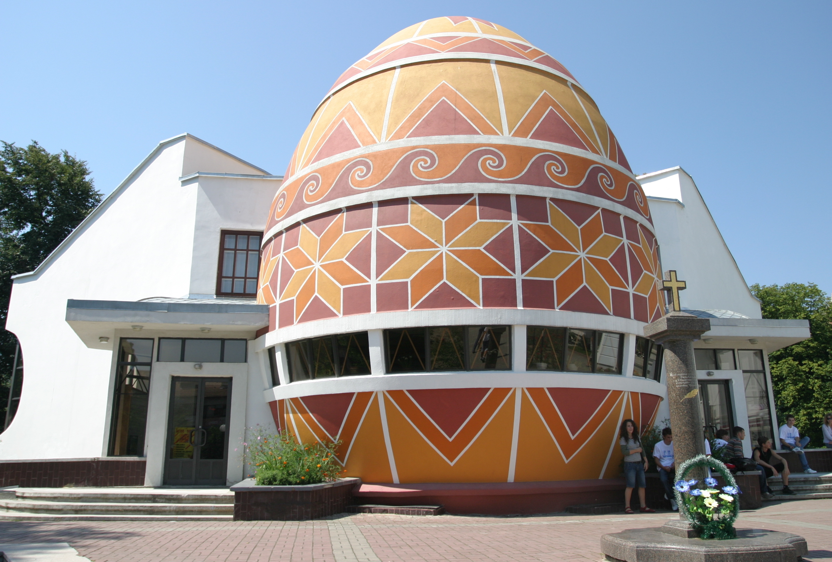
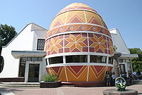 The Pysanka Museum, Kolomiya, Ukraine
Books featuring Kolomyia
- "Der Don Juan von Kolomea" (The Don Juan of Kolomyia), by Leopold von Sacher-Masoch
Notable people
- Jimmy Berg (1909–1988), composer
- Emanuel Feuermann (1902–1942), cellist
- Chaim Gross (1904–1991), sculptor
- Jan Ewangelista Nowicki (1894–1973), bishop of Lwów
- Potocki family members
- Stanisław "Rewera" Potocki (1579–1667)
- Józef Potocki (?-1692)
- Andrzej Potocki (1673–1751)
- Stanisław Potocki (?-1760)
- Sieniawski family members:
- Hieronim Jarosz Sieniawski (ca. 1516–1579)
- Roman Hryhorchuk (born 1965), football player
- Olena Iurkovska (born 1983), five time Paralympic Champion and Hero of Ukraine[7][8][9][10]
See also
- Pokuttya
- Kolomyjka, a dance in Ukrainian and Jewish klezmer music, which originated in Kolomyia.
- Pysanka Museum
- Red Ruthenia
- Ruthenian Voivodship
- Seven Wonders of Ukraine
References
- ^ City's website
- ^ Kolomea history
- ^ Kolomea history
- ^ Kolomea history
- ^ Kolomea history
- ^ http://www.ww2.dk/new/rvsn/44md.htm
- ^ Olena Iurkovska's profile on paralympic.org
- ^ (Ukrainian) Юрковська Олена Юріївна, Who-is-Who.com.ua
- ^ (Ukrainian) Документ 287/2006, Verkhovna Rada (April 3, 2006)
- ^ VIKTOR YUSHCHENKO DECORATES PARALYMPIST OLENA YURKOVSKA WITH GOLDEN STAR ORDER, Ukrinform (April 6, 2006)
External links
- ntktv.ua, the city's television
- kolomyya.org (in Ukrainian)
- pysanka.museum Pysanka Museum
- hutsul.museum Hutsul and Pokuttya National Folk Art Museum
- Kolomyya Tourist Directory (PDF)
- Heraldry and old pictures
- Picture gallery
- Kolomyia's Museum of Hutsul Folk Art
- New York-based Jewish organizations of exiles from Kolomyia
- JewishGen – The Kolomea Administrative District
- Memorial Book
- Photographs of Jewish sites in Kolomyia in the Jewish History in Galicia and Bukovina
- Kolomyya travel plan Your private guide in Kolomyya.
Administrative divisions of Ivano-Frankivsk Oblast, Ukraine Raions 

Cities Oblast subordinated citiesUrban-type
settlementsBytkiv · Bilshivtsi · Bohorodchany · Broshniv-Osada · Bukachivtsi · Chernelytsya · Delatyn · Hvizdets · Kuty · Lanchyn · Lysets · Obertyn · Otynia · Perehinske · Pechenizhyn · Rozhniativ · Solotvyn · Verkhovyna · Voynyliv · Vorokhta · Vyhoda · Yabluniv · Yezupil · ZabolotivCategories:- Cities in Ukraine
- Kolomyia
- Ivano-Frankivsk Oblast
- Galicia (Eastern Europe)
- Shtetls
- Populated places on the Prut

Wikimedia Foundation. 2010.