- Missouri Route 366
-
Route 366
Route information Maintained by MoDOT Length: 13 mi (21 km) Existed: 1979 – present Major junctions East end: South Broadway/South Jefferson Avenue/Chippewa Street in St. Louis  Route 30 in St. Louis
 Route P in Shrewsbury


 US 61/67/US 50 in Sunset Hills
West end: 
 I-44/US 50/I-270 in Sunset Hills
Highway system Missouri Highways
Supplemental←  Route 364
Route 367  →
→Route 366 is a highway located completely within the St. Louis metropolitan area. It is primarily a former section of U.S. Route 66. Beginning at South Broadway/South Jefferson Avenue in St. Louis and ending at the Interstate 44/Interstate 270 interchange in Sunset Hills, it was established in 1979 when US 66 was decertified between Chicago, Illinois and Joplin, Missouri.
Through the several suburbs of St. Louis it is known as Watson Road, while in the city of St. Louis itself, it is named Chippewa Street.
For 20 years, Route 366 was the only non-Interstate route in the City of St. Louis maintained by the State of Missouri. It officially extended eastward only to Brannon Avenue, two blocks west of South Kingshighway Boulevard.
In 1999, the Route 366 designation was extended east several miles, to include the remaining section of Chippewa Street that was previously part of United States Route 66 (from Chippewa to Gravois, where U.S. Route 66 had historically turned northeastward toward downtown St. Louis), as well as the section east of Gravois as far as South Broadway/South Jefferson Avenue which had never been part of U.S. Route 66.
The 1.2-mile (1.9 km) segment from South Grand Boulevard to South Broadway/South Jefferson Avenue is approximately the same width and configuration as a residential city street, with four-way stop signs at almost every intersection.
Major Intersections
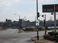 Route 366 in St. Louis. Route 366 is Chippewa Street (horizontal); the street running dead ahead is Gravois Avenue.
City of St. Louis segment known as Chippewa Street:
- Broadway / Jefferson Ave
- California Ave
- Compton Ave
- Grand Blvd
- Gustine Ave
- Gravois Ave
- Morganford Rd
- S. Kingshighway Blvd
- Brannon Ave
- Macklind Ave
- Hampton Ave
- Watson Rd / Bancroft Ave
- Sutherland Ave / Donovan Ave
- Lansdowne Ave
- Jamieson Ave
- River Des Peres Blvd
Enters St. Louis County in the 7100 block, name changes to Watson Road:
- Mackenzie Rd
- Trianon Parkway Dr
- Laclede Station Rd
- Edgar Rd
- Cheshire Lane
- Elm Ave / Rock Hill Rd
- Grant Rd
- Old Sappington Rd
- New Sappington Rd, Sappington Rd
- Glenwood Dr
- Lindbergh Blvd
- Geyer Rd, Rott Rd
 WEST / (end)
Categories:- State highways in Missouri
- U.S. Route 66
- Roads in St. Louis, Missouri
- Roads in St. Louis County, Missouri


Wikimedia Foundation. 2010.