- Eola, Oregon
-
Eola, Oregon — CDP — Former 1937 school in Eola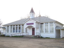 Location of Eola, Oregon
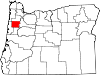
Coordinates: 44°55′55″N 123°7′7″W / 44.93194°N 123.11861°W Country United States State Oregon County Polk Area - Total 0.1 sq mi (0.2 km2) - Land 0.1 sq mi (0.2 km2) - Water 0.0 sq mi (0.0 km2) Elevation 230 ft (70 m) Population (2000) - Total 49 - Density 767.0/sq mi (296.1/km2) Time zone Pacific (PST) (UTC-8) - Summer (DST) PDT (UTC-7) FIPS code 41-23550[1] GNIS feature ID 1161035[2] Eola is an unincorporated community in Polk County, Oregon, United States four miles west of Salem on Oregon Route 22 at the confluence of Rickreall Creek and the Willamette River.
For statistical purposes, the United States Census Bureau has defined Eola as a census-designated place (CDP). The census definition of the area may not precisely correspond to local understanding of the area with the same name. The population of the CDP was 49 at the 2000 census. It is part of the Salem Metropolitan Statistical Area.
The Eola Hills rise north of the community and were named after it.[3]
Contents
History
Eola was originally named Cincinnati in 1844 by settlers Joshua "Sheep" Shaw and his son, A. C. R. Shaw, who thought the site resembled Cincinnati, Ohio, where Joshua once lived.[3][4] Joshua Shaw earned his nickname by being the first person to bring sheep overland to the Oregon Country via the Oregon Trail, also in 1844.[5]
Cincinnati post office was established in 1851, the first stop on a 70-mile mail route that included Nathaniel Ford's home in Rickreall and Nesmith's Mills at Ellendale.[3][5]
The Oregon Territorial Legislature incorporated the community with the name "Eola" in 1856.[3] The name comes from Aeolus, Greek god of the winds, though the reason for the name change is disputed.[3]
Cincinnati post office was also renamed. Eola post office ran until 1901 and was later reestablished from 1955-1965.[3]
The first school in Eola (then Cincinnati) was built in 1853.[6] Miss Abigail J. Scott, best known by her married name as the suffragist Abigail Scott Duniway, was the first teacher.[3][6] The original school burned down and was replaced by a school at Second and Mill streets in 1858.[4] This school served the community until 1937, and at the time was the oldest schoolhouse still in use in the state.[4] In 1937, a new school was built using a Works Progress Administration grant.[4] This building served as a public school facility until 2003.[7] Today the building is used as a church.
Geography
According to the United States Census Bureau, the CDP has a total area of 0.1 square miles (0.26 km2), all of it land.[8]
Demographics
As of the census[1] of 2000, there were 49 people, 29 households, and 6 families residing in the CDP. The population density was 767.0 people per square mile (315.3/km²). There were 36 housing units at an average density of 563.5 per square mile (231.7/km²). The racial makeup of the CDP was 89.80% White, 8.16% from other races, and 2.04% from two or more races. Hispanic or Latino of any race were 8.16% of the population.
There were 29 households out of which 3.4% had children under the age of 18 living with them, 20.7% were married couples living together, and 75.9% were non-families. 69.0% of all households were made up of individuals and 13.8% had someone living alone who was 65 years of age or older. The average household size was 1.69 and the average family size was 3.14.
In the CDP the population was spread out with 10.2% under the age of 18, 4.1% from 18 to 24, 26.5% from 25 to 44, 49.0% from 45 to 64, and 10.2% who were 65 years of age or older. The median age was 50 years. For every 100 females there were 122.7 males. For every 100 females age 18 and over, there were 131.6 males.
The median income for a household in the CDP was $12,361, and the median income for a family was $0. Males had a median income of $0 versus $0 for females. The per capita income for the CDP was $9,489. There were no families and 29.8% of the population living below the poverty line, including no under eighteens and none of those over 64.
References
- ^ a b "American FactFinder". United States Census Bureau. http://factfinder.census.gov. Retrieved 2008-01-31.
- ^ "US Board on Geographic Names". United States Geological Survey. 2007-10-25. http://geonames.usgs.gov. Retrieved 2008-01-31.
- ^ a b c d e f g McArthur, Lewis A.; Lewis L. McArthur (2003) [1928]. Oregon Geographic Names (7th ed.). Portland, Oregon: Oregon Historical Society Press. p. 333. ISBN 0-87595-277-1.
- ^ a b c d Corning, Howard McKinley (1973) [1947]. "Eola, The Town That Was Cincinnati". Willamette Landings: Ghost Towns of the River (2nd ed.). Portland, Oregon: Oregon Historical Society. pp. 132–138. ISBN 0-87595-042-6.
- ^ a b Wirfs, Charlotte L. (1980). "Tour No. 1: Early Settlements of N.E. Polk County". Historically Speaking (Polk County Historical Society) IV: 4.
- ^ a b Our History of Education
- ^ Itemizer Observer "Eola, Oak Grove schools face closure" April 29, 2003. Accessed March 15, 2009.
- ^ "US Gazetteer files: 2010, 2000, and 1990". United States Census Bureau. 2011-02-12. http://www.census.gov/geo/www/gazetteer/gazette.html. Retrieved 2011-04-23.
External links
- Historic images of Eola from Salem Public Library
- Reprint of Statesman Journal article on Eola
- Modern image of Eola School from Discover Neighborhood History
Coordinates: 44°55′55″N 123°07′07″W / 44.931898°N 123.11871°W
Municipalities and communities of Polk County, Oregon Cities Dallas | Falls City | Independence | Monmouth | Salem‡ | Willamina‡
CDPs Eola | Grand Ronde | Rickreall
Unincorporated
communitiesAirlie | Ballston | Bethel | Bridgeport | Brunks Corner | Buena Vista | Lewisville | McCoy | Modeville | Pedee | Perrydale | Salt Creek | Valley Junction | Zena
Indian reservation Ghost towns Footnotes ‡This populated place also has portions in an adjacent county or counties
Categories:- Census-designated places in Oregon
- Salem, Oregon metropolitan area
- Ghost towns in Oregon
- Unincorporated communities in Polk County, Oregon


Wikimedia Foundation. 2010.