- North East, New York
-
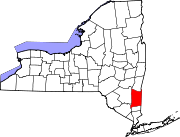
North East, New York — Town — Downtown Millerton, NY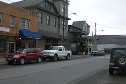 Location within the state of New York
 North East, New York
Coordinates: 41°56′45″N 73°31′38″W / 41.94583°N 73.52722°WCoordinates: 41°56′45″N 73°31′38″W / 41.94583°N 73.52722°W Country United States State New York County Dutchess Government - Type Town Council - Town Supervisor David Sherman (R) - Town Council Members' ListArea - Total 43.7 sq mi (113.2 km2) - Land 43.4 sq mi (112.3 km2) - Water 0.3 sq mi (0.8 km2) Elevation 1,017 ft (310 m) Population (2000) - Total 3,002 - Density 69.2/sq mi (26.7/km2) Time zone Eastern (EST) (UTC-5) - Summer (DST) EDT (UTC-4) FIPS code 36-51891 GNIS feature ID 0979285 North East is a town in Dutchess County, New York, United States. The population was 3,002 at the 2000 census.
The Town of North East is in the northeastern part of the county. US Route 44 crosses the town.
Contents
History
Part of the town was from the Great Nine Partners Patent of 1697 and part of the Little Nine Partners Patent of 1706. The town was first settled by Europeans around 1725, in a region called "The Oblong," which was not part of the Patent.
The Town of Northeast was formed in 1788. Parts of the town were taken to form the Towns of Milan (1818) and Pine Plains (1823).
Geography
According to the United States Census Bureau, the town has a total area of 43.7 square miles (113 km2). 43.4 square miles (112 km2) of it is land and 0.3 square miles (0.78 km2) of it is water. The total area is 0.76% water.
The north town line is the border of Columbia County, New York, but a small part of the town line borders Massachusetts. The east town line is the border of Connecticut.
Demographics
As of the census[1] of 2000, there were 3,002 people, 1,146 households, and 778 families residing in the town. The population density was 69.2 people per square mile (26.7/km²). There were 1,366 housing units at an average density of 31.5 per square mile (12.2/km²). The racial makeup of the town was 95.60% White, 2.10% African American, 0.10% Native American, 0.57% Asian, 0.03% Pacific Islander, 0.70% from other races, and 0.90% from two or more races. Hispanic or Latino of any race were 3.26% of the population.
There were 1,146 households out of which 28.7% had children under the age of 18 living with them, 54.7% were married couples living together, 9.7% had a female householder with no husband present, and 32.1% were non-families. 25.7% of all households were made up of individuals and 11.1% had someone living alone who was 65 years of age or older. The average household size was 2.50 and the average family size was 2.97.
In the town the population was spread out with 23.1% under the age of 18, 9.2% from 18 to 24, 26.7% from 25 to 44, 27.0% from 45 to 64, and 14.0% who were 65 years of age or older. The median age was 40 years. For every 100 females there were 98.2 males. For every 100 females age 18 and over, there were 94.3 males.
The median income for a household in the town was $42,038, and the median income for a family was $48,179. Males had a median income of $30,659 versus $26,346 for females. The per capita income for the town was $24,650. About 7.0% of families and 12.3% of the population were below the poverty line, including 17.1% of those under age 18 and 10.7% of those age 65 or over.
Communities and locations in North East
- Boston Corner – A hamlet at the north town line. Portions of the hamlet are in Ancram, New York in Columbia County.
- Coleman Station – A hamlet in the south part of the town.
- Irondale – A hamlet northwest of Millerton village.
- Millerton – The Village of Millerton is on Route 44 near the Connecticut border.
- Mount Riga – A hamlet in the northern part of the town.
- Northeast – A location southwest of Northeast Center.
- Northeast Center – A hamlet southwest of Millerton on Route 44.
- Oblong – A former community in the town.
- Perry Corners – A location in the southern part of the town.
- Sharon Station – A hamlet on the south town line.
- Shekomeko – A hamlet in the southwest part of the town.
- Spencer Corners – A hamlet named after early settler Philip Spencer, northeast of Millerton.
- State Line – A hamlet east of Millerton village on the New York–Connecticut border.
- Taconic State Park – A state park in the northern part of the town.
- Whitehouse Crossing – A hamlet in the northern part of the town.
References
- ^ "American FactFinder". United States Census Bureau. http://factfinder.census.gov. Retrieved 2008-01-31.
External links
Municipalities and communities of Dutchess County, New York County seat: Poughkeepsie Cities Beacon | Poughkeepsie
Towns Amenia | Beekman | Clinton | Dover | East Fishkill | Fishkill | Hyde Park | LaGrange | Milan | North East | Pawling | Pine Plains | Pleasant Valley | Poughkeepsie | Red Hook | Rhinebeck | Stanford | Union Vale | Wappinger | Washington
Villages CDPs Other
hamletsAnnandale-on-Hudson | Barrytown | Boston Corner‡ | Chelsea | Linden Acres | Mabbettsville | New Hamburg | Pleasant Plains | Quaker Hill | Rhinecliff | Salt Point | Shekomeko | Sylvan Lake | Van Keurens | Verbank | Wassaic
Footnotes ‡This populated place also has portions in an adjacent county or counties
Categories:- North East, New York
- Towns in New York
- Poughkeepsie–Newburgh–Middletown metropolitan area
- Populated places in Dutchess County, New York


Wikimedia Foundation. 2010.