- Painted Rock Dam
Infobox_Dam
dam_name = Painted Rock Dam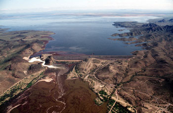
caption = Photo taken during period of high runoff, with the resultant reservoir nearly full
official_name = Painted Rock Dam
crosses =Gila River
reservoir = Painted Rock Reservoir
locale = SouthwesternArizona
maint =United States Army Corps of Engineers
length = convert|4780|ft|m
height = convert|181|ft|m
width =
began = 18 Jan 1960
open = 25 July 1957
cost = $13,670,000
reservoir_capacity = convert|2491700|acre ft
bridge_id =
map_cue =
map_
map_text =
map_width =
coordinates = coord|33|4|22|N|113|0|56|W
extra =The Painted Rock Dam is an earthfill
embankment dam located west of Gila Bend,Arizona . It is primarily used forflood control purposes.Description
The Painted Rock Dam was constructed during a 3 year period from 1957-1960 by the
United States Army Corps of Engineers to help control seasonal floods on the lower reaches of theGila River . The river had no significant impediments between theColorado River and theCoolidge Dam hundreds of miles upstream. As the river receives several tributaries, including the Hassayampa, Agua Friariver s, and most importantly theSalt River and its major tributary, theVerde River . Due to a relatively large watershed of convert|50800|sqmi, more than half of which is unregulated, the flood threat to small farming communities downstream on the Gila River is large, and seasonal flooding of these areas prior to the construction of the dam was significant. [cite web|url=http://www.spl.usace.army.mil/resreg/htdocs/ptrk.html|title=Painted Rock Dam|accessdate=2008-06-03|publisher=Army Corps of Engineers]The area surrounding the dam has also hosted a number of historical events. The
Butterfield Overland Mail route passed through the area, as did the path followed by theMormon Battalion . Evidence of both can be found, as well as the expedition ofJuan Bautista De Anza in 1774. Inscriptions made by these groups can be found in various sites in the region. Near the dam site, there is also a campground maintained by theBureau of Land Management that showcases a number of prehistoricpetroglyph s, indicating human involvement in the region long predating Western influence. [cite web|url=http://www.gilabendaz.org/index.asp?Type=B_BASIC&SEC=%7B25DAFADA-8323-4573-BD93-E76A27EA17FE%7D|title=Painted Rock Petroglyph Site|accessdate=2008-06-03|publisher=Town of Gila Bend]Infobox lake
align = left
lake_name = Painted Rock Reservoir
image_lake =
caption_lake =
image_bathymetry =
caption_bathymetry =
location =Arizona
coords = coord|33|4|22|N|113|0|56|W|type:waterbody_region:US-AZ|name=Painted Rock Reservoir
type =reservoir
inflow =Gila River
outflow = Gila River, "evaporation "
catchment = convert|50800|sqmi|abbr=on
basin_countries = United States
length =
width =
area = convert|53200|acre|km2|abbr=on (maximum)
depth =
max-depth = convert|181|ft|m|abbr=on
volume = convert|2491700|acre.ft|km3|abbr=on|lk=on (maximum)
residence_time =
shore =
elevation = convert|661|ft|abbr=on
islands =
cities =Painted Rock Reservoir
The Painted Rock Reservoir is an artificial
reservoir impounded by the Painted Rock Dam. The reservoir, with a maximum storage capacity of convert|2491700|acre ft, has the potential to be the largest reservoir completely within the borders of the state of Arizona, but because the Gila River and it's main tributary, the Salt River, are generally almost always completely diverted for irrigation and municipal water use for Phoenix, the lake is often dry.In 2005, heavy runoff filled the reservoir to record levels, swelling the lake to become the second largest by area in the state of Arizona, trailing only
Theodore Roosevelt Lake . However, extremely high levels ofpesticide s, particularly the now-bannedDDT , had built up in the farmlands upstream from the reservoir in the decades prior and accumulated in the lake during the flood. The extreme toxicity of the lake rendered it unsuitable for recreational uses and public access to both the lake and the dam was restricted. [cite news|url=http://www.phoenixnewtimes.com/2005-03-10/news/contaminated-splendor/|title=Contaminated Splendor|first=John|last=Dougherty|date=2005-03-10|accessdate=2008-06-03|publisher=Phoenix New Times ] Similar runoff had filled the lake previously in 1993 and 1980, and in each instance the lake lasted only a few months before emptying due to evaporation and release downstream.References
Wikimedia Foundation. 2010.