- Dendora Valley
-
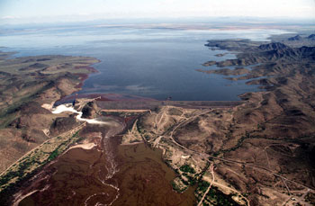
Dendora Valley Valley  Painted Rock Dam and Gila River, eastern border of the Dendora Valley
(view due east)Country United States State Arizona Region Gila River Valley
((northwest)-Sonoran Desert)District Maricopa County, Arizona Borders on Gila Bend Mountains-N
Painted Rock Reservoir-E
Painted Rock Mountains-S
Hyder Valley-WRiver Gila River Coordinates 33°3′9″N 113°4′56″W / 33.0525°N 113.08222°W Length 9 mi (14 km), E-W, (turns NW at west) Width 6 mi (10 km) 
 Dendora Valley
in ArizonaThe Dendora Valley is a small valley on the Gila River west of Painted Rock Dam and Reservoir. The valley is north of the river, and is the valley west of the north-south Painted Rock Mountains which form the western end of the Painted Rock Reservoir.
The Dendora Valley is only about 9 miles (14 km) long. The Gila Bend Mountains form the northern border from east to west, of both Dendora Valley, and the Painted Rock Reservoir adjacent eastwards; this is the famous Gila Bend formed by the Gila River as it changes direction to south, then west entering the reservoir. Other small mountains and hills border the southwest, namely Oatman Mountain, at 1,732 feet (528 m) and the Face Mountain group with Montezuma Head, (peak) to the west.
The easiest access route to the Dendora Valley is from Hyder in the Hyder Valley about 15 miles (24 km) west-southwest.
The coordinates for Oatman Mountain, on the southwest border of Dendora Valley are 33°3′6.1″N 113°8′5.6″W / 33.051694°N 113.134889°W.[1]
References
External links
Categories:- Gila River
- Valleys of Arizona
- Landforms of Maricopa County, Arizona
- Arizona geography stubs

Wikimedia Foundation. 2010.