- Essex Fells, New Jersey
Infobox Settlement
official_name = Essex Fells, New Jersey
settlement_type = Borough
nickname =
motto =
imagesize =
image_caption =
image_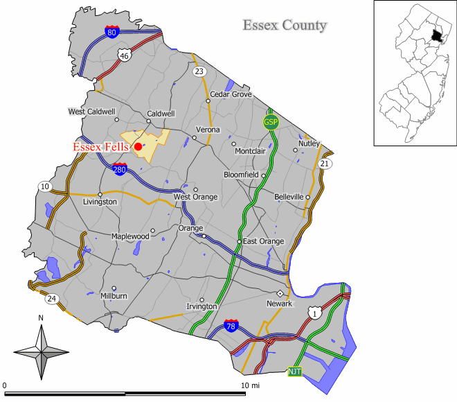
mapsize = 250x200px
map_caption = Map of Essex Fells in Essex County. Inset: Location of Essex County highlighted in the State of New Jersey.
mapsize1 = 250x200px
map_caption1 = Census Bureau map of Essex Fells, New Jerseysubdivision_type = Country
subdivision_name =United States
subdivision_type1 = State
subdivision_name1 =New Jersey
subdivision_type2 = County
subdivision_name2 = Essex
government_footnotes =
government_type = Borough
leader_title =Mayor
leader_name = Ed Abbot
leader_title1 =
leader_name1 =
established_title = Incorporated
established_date =March 31 ,1902 unit_pref = Imperial
area_footnotes =
area_magnitude =
area_total_km2 = 3.7
area_land_km2 = 3.7
area_water_km2 = 0.0
area_total_sq_mi = 1.4
area_land_sq_mi = 1.4
area_water_sq_mi = 0.0population_as_of = 2006
population_footnotes =
population_total = 2071
population_density_km2 = 592.3
population_density_sq_mi = 1534.0timezone = Eastern (EST)
utc_offset = -5
timezone_DST = EDT
utc_offset_DST = -4
elevation_footnotes = [Gnis|876217|Essex Fells,Geographic Names Information System , accessedJanuary 4 ,2008 .]
elevation_m = 152
elevation_ft = 499
latd = 40 |latm = 49 |lats = 39 |latNS = N
longd = 74 |longm = 16 |longs = 51 |longEW = Wpostal_code_type =
ZIP code
postal_code = 07021
area_code = 973
blank_name = FIPS code
blank_info = 34-21840GR|2 [ [http://mcdc2.missouri.edu/webrepts/commoncodes/ccc_nj.html A Cure for the Common Codes: New Jersey] , Missouri Census Data Center. AccessedJuly 14 ,2008 .]
blank1_name = GNIS feature ID
blank1_info = 0876217GR|3
website = http://essexfellsboro.com/
footnotes =Essex Fells is a borough in Essex County,
New Jersey ,United States . As of theUnited States 2000 Census , the borough population was 2,162. Essex Fells was incorporated as a borough by an Act of theNew Jersey Legislature onMarch 31 ,1902 , from portions of Caldwell Township (now Fairfield Township)."The Story of New Jersey's Civil Boundaries: 1606-1968", John P. Snyder, Bureau of Geology and Topography; Trenton, New Jersey; 1969. p. 127.] In 1981, Essex Fells became a township to take advantage offederal revenue sharing policies. [New Jersey State Commission on County and Municipal Government , [http://www.njstatelib.org/NJ_Information/Digital_Collections/DIGIDOX1.php Modern Forms of Municipal Government] , 1992, [http://www.njstatelib.org/NJ_Information/Digital_Collections/MFMG/MFMGCH6.PDF Chapter VI: Municipal Names and Municipal Classification] ] EffectiveJanuary 1 ,1992 , it again became a borough. [U.S. Census Bureau , [http://www.census.gov/popest/archives/1990s/boundary_changes/34.html 1990s boundary changes: New Jersey] , accessed June 2008]"
New Jersey Monthly " magazine ranked Essex Fells as its 10th best place to live in its 2008 rankings of the "Best Places To Live" in New Jersey. [ [http://njmonthly.com/articles/best_of/placestolive/best-places-to-live---the-complete-top-towns-list-.html "Best Places To Live - The Complete Top Towns List 1-100"] , "New Jersey Monthly ",February 21 ,2008 . AccessedFebruary 24 ,2008 .]Geography
Essex Fells is located at coor dms|40|49|39|N|74|16|51|W|city (40.827499, -74.280918)GR|1.
According to the
United States Census Bureau , the borough has a total area of 1.4 square miles (3.7 km²), all of it land.Grover Cleveland Park , the seventh largest park in the Essex County park system, is a heavily wooded park covering convert|41.48|acre|m2 in the western section of the county along the Caldwell-Essex Fells border.Demographics
USCensusPop
1930=1115
1940=1466
1950=1617
1960=2174
1970=2541
1980=2363
1990=2139
2000=2162
estimate=2071
estyear=2006
estref= [http://factfinder.census.gov/servlet/SAFFPopulation?_event=Search&geo_id=16000US3419390&_geoContext=01000US%7C04000US34%7C16000US3419390&_street=&_county=essex+fells&_cityTown=essex+fells&_state=04000US34&_zip=&_lang=en&_sse=on&ActiveGeoDiv=geoSelect&_useEV=&pctxt=fph&pgsl=160&_submenuId=population_0&ds_name=null&_ci_nbr=null&qr_name=null®=null%3Anull&_keyword=&_industry= Census data for Essex Fells borough] ,United States Census Bureau , accessedMarch 1 ,2007 ]
footnote=Population 1930 - 1990. [ [http://www.wnjpin.net/OneStopCareerCenter/LaborMarketInformation/lmi01/poptrd6.htm New Jersey Resident Population by Municipality: 1930 - 1990] , accessedMarch 1 ,2007 ] As of thecensus GR|2 of 2000, there were 2,162 people, 737 households, and 605 families residing in the borough. Thepopulation density was 1,534.0 people per square mile (592.0/km²). There were 761 housing units at an average density of 540.0/sq mi (208.4/km²). The racial makeup of the borough was 96.95% White, 0.46% African American, 0.19% Native American, 1.02% Asian, 0.14% from other races, and 1.25% from two or more races. Hispanic or Latino of any race were 1.20% of the population.There were 737 households out of which 40.0% had children under the age of 18 living with them, 75.3% were married couples living together, 5.3% had a female householder with no husband present, and 17.9% were non-families. 15.1% of all households were made up of individuals and 8.4% had someone living alone who was 65 years of age or older. The average household size was 2.93 and the average family size was 3.28.
In the borough the population was spread out with 29.7% under the age of 18, 3.6% from 18 to 24, 24.5% from 25 to 44, 27.5% from 45 to 64, and 14.7% who were 65 years of age or older. The median age was 40 years. For every 100 females there were 96.9 males. For every 100 females age 18 and over, there were 94.6 males.
The median income for a household in the borough was $148,173, and the median income for a family was $175,000. Males had a median income of $100,000 versus $52,266 for females. The
per capita income for the borough was $77,434. About 0.3% of families and 1.1% of the population were below thepoverty line , including 0.9% of those under age 18 and 0.6% of those age 65 or over.Government
Local government
Essex Fells is governed under the Borough form of New Jersey municipal government. The government consists of a Mayor and a Borough Council comprising six council members, with all positions elected at large. A Mayor is elected directly by the voters to a four-year term of office. The Borough Council consists of six members elected to serve three-year terms on a staggered basis, with two seats coming up for election each year. ["2005 New Jersey Legislative District Data Book",
Rutgers University Edward J. Bloustein School of Planning and Public Policy , April 2005, p. 125.]The
Mayor of Essex Fells is Ed Abbot. Members of the Essex Fells borough council are Michael Cecere, Anne Denehy, Tom McCaffrey, George Peck, Jack Taylor and Pat Wahl. [ [http://essexfellsboro.com/council.htm Essex Fells Mayor and Council] , Borough of Essex fells. AccessedFebruary 4 ,2008 .]Federal, state and county representation
Essex Fells is in the Eleventh Congressional District and is part of New Jersey's 27th Legislative District. [ [http://www.lwvnj.org/pubs/CG06.pdf League of Women Voters: 2006 New Jersey Citizen's Guide to Government] , p. 57, accessed
August 30 ,2006 .]Politics
On the national level, Essex Fells leans toward the Republican Party. In 2004, Republican
George W. Bush received 69% of the vote here, defeating DemocratJohn Kerry , who received around 30%.On a local level, Essex Fells has elected a Republican mayor in every vote held since becoming a borough in 1902. [ [http://query.nytimes.com/gst/fullpage.html?res=9902E4D7153DF93BA15756C0A9669C8B63 "If You're Thinking of Living In/Essex Fells, N.J.; No Stores and No Apartments, by Law"] , "
The New York Times ",May 28 ,2000 .]Education
The
Essex Fells School District serves public school students in kindergarten through sixth grade. Essex Fells School had an enrollment of 268 students as of the 2005-06 school year. [ [http://nces.ed.gov/ccd/schoolsearch/school_list.asp?Search=1&DistrictID=3404830 Data for the Essex Fells School] ,National Center for Education Statistics . AccessedJune 11 ,2008 .]Students in public school for grades 7 - 12 attend the
West Essex Regional School District , a regional school district serving students from four municipalities in western Essex County,New Jersey . Communities served by the district's schools are Essex Fells, Fairfield, North Caldwell and Roseland. [ [http://education.state.nj.us/rc/rc07/narrative/13/5630/13-5630-050.html West Essex Regional High School 2007 School Report Card] ,New Jersey Department of Education . AccessedMarch 1 ,2008 . "West Essex High School is located in North Caldwell and serves the four area sending districts of Essex Fells, Fairfield, North Caldwell, and Roseland."] Schools in the district (with 2005-06 enrollment data from theNational Center for Education Statistics [ [http://nces.ed.gov/ccd/schoolsearch/school_list.asp?Search=1&DistrictID=3417460 Data for the West Essex Regional School District] ,National Center for Education Statistics . AccessedAugust 4 ,2008 .] ) are [http://www.westex.org/juniorhigh/index.html West Essex Junior High School] (grades 7-9; 833 students) andWest Essex High School (grades 10-12; 729 students).History
Essex Fells was part of the
Horseneck Tract , which was an area that consisted of what are now the municipalities of Caldwell, West Caldwell, North Caldwell, Fairfield, Verona, Cedar Grove, Essex Fells, Roseland, and portions of Livingston and West Orange.In 1702, settlers purchased the 14,000 acre (57 km²) Horseneck Tract — so-called because of its irregular shape that suggested a horse's neck and head — from the
Lenni Lenape Native Americans for goods equal to $325. This purchase encompassed much of western Essex County, from the "Orange", or "First Mountain" in the Watchung Mountain range to thePassaic River .References
External links
* [http://essexfellsboro.com/ Essex Fells Borough website]
* [http://www.efsk-6.org Essex Fells School]
*NJReportCard|13|1400|0|Essex Fells School
* [http://nces.ed.gov/ccd/schoolsearch/school_list.asp?Search=1&DistrictID=3404830 Data for the Essex Fells School] ,National Center for Education Statistics
* [http://www.Westex.org West Essex Regional School District]
Wikimedia Foundation. 2010.