- Avalon, New Jersey
Infobox Settlement
official_name = Avalon, New Jersey
settlement_type = Borough
nickname =
motto = "Cooler by a Mile"
imagesize =
image_caption =
image_
imagesize =
image_caption =
image_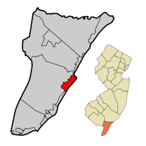
mapsize = 250x200px
map_caption = Avalon Borough highlighted in Cape May County. Inset
mapsize1 = 250x200px
map_caption1 = Census Bureau map of Avalon, New Jerseysubdivision_type = Country
subdivision_name =United States
subdivision_type1 = State
subdivision_name1 =New Jersey
subdivision_type2 = County
subdivision_name2 = Cape May
government_footnotes =
government_type =Faulkner Act (Mayor-Council)
leader_title =Mayor
leader_name = Martin L. Pagliughi
leader_title1 =
leader_name1 =
established_title = Incorporated
established_date =April 18 ,1892 unit_pref = Imperial
area_footnotes =
area_magnitude =
area_total_km2 = 12.7
area_land_km2 = 10.9
area_water_km2 = 1.7
area_total_sq_mi = 4.9
area_land_sq_mi = 4.2
area_water_sq_mi = 0.7population_as_of = 2007
population_footnotes =
population_total = 2103
population_density_km2 = 196.3
population_density_sq_mi = 508.4timezone = Eastern (EST)
utc_offset = -5
timezone_DST = EDT
utc_offset_DST = -4
elevation_footnotes = [Gnis|885146|Borough of Avalon,Geographic Names Information System . AccessedJanuary 4 ,2008 .]
elevation_m = 3
elevation_ft = 10
latd = 39 |latm = 05 |lats = 30 |latNS = N
longd = 74 |longm = 44 |longs = 12 |longEW = Wpostal_code_type =
ZIP code
postal_code = 08202
area_code = 609
blank_name = FIPS code
blank_info = 34-02320GR|2 [ [http://mcdc2.missouri.edu/webrepts/commoncodes/ccc_nj.html A Cure for the Common Codes: New Jersey] , Missouri Census Data Center. AccessedJuly 14 ,2008 .]
blank1_name = GNIS feature ID
blank1_info = 0885146GR|3
website = http://www.avalonboro.org
footnotes =Avalon is a borough in Cape May County,
New Jersey , onSeven Mile Island . A small portion of Avalon is not on Seven Mile Island. It is part of the Ocean CityMetropolitan Statistical Area . As of theUnited States 2000 Census , the full-time borough population was 2,143, although it swells during the summer months.Avalon was incorporated as a borough by an Act of the
New Jersey Legislature onApril 18 ,1892 , from portions of Middle Township, based on the results of a referendum held two days earlier. The borough was reincorporated onMarch 6 ,1896 , and again onMay 4 ,1897 . Another portion of Middle Township was annexed in 1910. OnDecember 27 ,1941 , portions of Avalon were ceded to Stone Harbor."The Story of New Jersey's Civil Boundaries: 1606-1968", John P. Snyder, Bureau of Geology and Topography; Trenton, New Jersey; 1969. p. 113.]Avalon, famous for being a South Jersey seashore resort, has the motto "Cooler by a Mile." since it juts out into the
Atlantic Ocean about a mile farther than otherbarrier island resorts. It was ranked the seventh best beach in New Jersey in the 2008 Top 10 Beaches Contest sponsored by the New Jersey Marine Sciences Consortium. [cite news |last=Urgo |first=Jacqueline L. |title=Triumph for South Jersey |publisher=The Philadelphia Inquirer |date=May 23 ,2008 |url=http://www.philly.com/philly/hp/entertainment/19204259.html |accessdate=2008-05-30]Geography
Avalon is located at coor dms|39|5|35|N|74|43|37|W|city (39.092928, -74.726880)GR|1.
According to the
United States Census Bureau , the borough has a total area of 4.9square mile s (12.7km² ), of which, 4.2 square miles (10.9 km²) of it is land and 0.7 square miles (1.7 km²) of it (13.70%) is water.Avalon borders Sea Isle City, Stone Harbor Borough, Middle Township, and the
Atlantic Ocean .Demographics
USCensusPop
1930= 343
1940= 313
1950= 428
1960= 695
1970= 1283
1980= 2162
1990= 1809
2000= 2143
estimate=2103
estyear=2007
estref= [http://factfinder.census.gov/servlet/SAFFPopulation?_event=Search&geo_id=16000US3482450&_geoContext=01000US%7C04000US34%7C16000US3482450&_street=&_county=avalon&_cityTown=avalon&_state=04000US34&_zip=&_lang=en&_sse=on&ActiveGeoDiv=geoSelect&_useEV=&pctxt=fph&pgsl=160&_submenuId=population_0&ds_name=null&_ci_nbr=null&qr_name=null®=null%3Anull&_keyword=&_industry= Census data for Avalon borough] ,United States Census Bureau . Accessed October 6, 2008.]
footnote=Population 1930 - 1990 [ [http://www.wnjpin.net/OneStopCareerCenter/LaborMarketInformation/lmi01/poptrd6.htm New Jersey Resident Population by Municipality: 1930 - 1990] , Workforce New Jersey Public Information Network. AccessedMarch 1 ,2007 .] As of thecensus GR|2 of 2000, there were 2,143 people, 1,045 households, and 668 families residing in the borough. Thepopulation density was 508.4 people per square mile (196.5/km²). There were 5,281 housing units at an average density of 1,252.9/sq mi (484.3/km²). The racial makeup of the borough was 98.69% White, 0.14% African American, 0.56% Asian, 0.05% Pacific Islander, 0.05% from other races, and 0.51% from two or more races. Hispanic or Latino of any race were 0.56% of the population.There were 1,045 households out of which 12.9% had children under the age of 18 living with them, 56.7% were married couples living together, 5.5% had a female householder with no husband present, and 36.0% were non-families. 33.4% of all households were made up of individuals and 17.8% had someone living alone who was 65 years of age or older. The average household size was 2.05 and the average family size was 2.56.
In the borough the population was spread out with 14.1% under the age of 18, 2.9% from 18 to 24, 16.3% from 25 to 44, 33.9% from 45 to 64, and 32.7% who were 65 years of age or older. The median age was 56 years. For every 100 females there were 94.8 males. For every 100 females age 18 and over, there were 91.0 males.
The median income for a household in the borough was $59,196, and the median income for a family was $72,750. Males had a median income of $60,227 versus $39,886 for females. The
per capita income for the borough was $50,016. About 2.2% of families and 4.3% of the population were below thepoverty line , including 9.6% of those under age 18 and 0.1% of those age 65 or over.Government
Local government
The Borough of Avalon is governed under the
Faulkner Act (Mayor-Council) system of municipal government by a Mayor and a five-member Borough Council. Members of the Borough Council are elected in non-partisan elections to four-year terms on a staggered basis, with one or two seats coming up for election each year."2005 New Jersey Legislative District Data Book",Rutgers University Edward J. Bloustein School of Planning and Public Policy , April 2005, p. 8.]Avalon's
Mayor is Martin L. Pagliughi. Members of the Borough Council are Council President Nancy M. Hudanich, Ed. D., Council Vice President Joseph V. Tipping, Charles P. Covington, Richard E. Dean and David B. Ellenberg. [ [http://www.avalonboro.org/munoffices.htm Municipal Offices] , Borough of Avalon. AccessedApril 24 ,2008 .]Federal, state and county representation
Avalon is in the Second Congressional District and is part of New Jersey's 1st Legislative District. [ [http://www.lwvnj.org/pubs/CG06.pdf 2006 New Jersey Citizen's Guide to Government] , New Jersey
League of Women Voters , p. 54. AccessedAugust 30 ,2006 .]Education
Avalon School District is a public school district that serves students in public school for Kindergarten through eighth grade. Avalon Elementary School had an enrollment of 82 students in the 2005-06 school year. [ [http://nces.ed.gov/ccd/schoolsearch/school_list.asp?Search=1&DistrictID=3401110 Data for the Avalon Elementary School] ,National Center for Education Statistics . AccessedApril 24 ,2008 .]Students in public school for grades 9-12 attend
Middle Township High School in Cape May Court House, as part of asending/receiving relationship with theMiddle Township Public Schools . [ [http://education.state.nj.us/rc/rc06/narrative/09/3130/09-3130-050.html Middle Township High School 2006 School Report Card] ,New Jersey Department of Education . AccessedFebruary 13 ,2008 . "Middle Township High School is a four-year, accredited, comprehensive high school situated in central Cape May County. The school serves the communities of Middle Township, Dennis Township, Avalon, and Stone Harbor."]Transportation
Avalon Boulevard connects the
Garden State Parkway and U.S. 9 to the oceanfront.There is also a seasonal trolley service that runs through the seven-mile long island. Avalon also has multiple
New Jersey Transit bus stops.History
Early history
Originally a thriving juniper forest, reportedly occupied by
Lenni Lenape Native Americans, the area was purchased by Aaron Leaming in December 1722 for 79 Pounds. Known as Seven Mile Beach (present day Avalon and Stone Harbor), it was owned and retained by the Leamings for approximately 100 years. It served as a cattle range and was also used for its plentiful timber. The Leamings eventually sold the land, and the island exchanged hands in a number of transactions afterwards. In April 1887, the Seven Mile Beach company was formed. As early as 1893, Avalon was advertised as a resort town. With this rapid development, homes and businesses were erected. The nativejuniper forest was graded and cut, and the sandy hills were leveled off, making the island mostly flat. Today it is extremely rare to see hills or native juniper in Avalon.By the early 1900s, the Leaming Railroad bridge was constructed, allowing train connections into the town. This increased the traffic from nearby
Philadelphia ,Pennsylvania . Around 1944 the West Jersey and Seashore railroad lines merged with theReading Railroad . This effectively ended the era of travel by train to the island. A hurricane took several streets and Avalon now has a north end beginning at 7th street. In the mid-1950s the Wolfington Family of Philadelphia purchased and operated the Puritan Hotel later enlarged and re-named the Whitebriar Hotel on the beach block at 21st Street. The Whitebriar was managed for a few seasons in the mid-1950s by one of the future 'great hosts' of Philadelphia hotels, Robert C. Bennett. Currently the most widely used method of transportation to and from Avalon is by car or boat; however, buses run on a regular schedule all over the shore towns.The Commonwealth (shipwreck)
On
January 4 ,1890 , the "Commonwealth", piloted by Captain W.S. Willets, sank. This 197-ton ship was en route fromNew York City toPhiladelphia with a cargo of molasses, coffee, tobacco, tea, coconut oil, and camphor. Straying from its course in rough weather, the "Commonwealth" ran aground in Townsend's Inlet. The crew was rescued and most of the cargo was salvaged. However, after a week trapped in the sandy bottom of the inlet, the ship began to come apart in the waves. Some of the remaining cargo washed ashore and most of it was taken by the early residents of Avalon. The wreck, unable to be recovered, was sold to John Townshend onFebruary 2 .The Nor'easter of 1962
In March 1962, a major
Nor'easter , theAsh Wednesday Storm of 1962 , tore through the U.S. East Coast causing massive ocean swells. Much of Avalon suffered serious flooding and major coastline loss. [ [http://www.visitnjshore.com/New-Jersey-Shore/Avalon/Avalon-History.asp History of Avalon] . AccessedJan 25 2007 .] [ [http://www.avalonspast.com/doRemember/45YearsAgo.aspx Avalon Residents Recall 1962 Storm] . AccessedApril 11 ,2007 .] While there have been many strong storms since 1962, extensive rock jetty construction on Townsends Inlet (as recent as Summer 2006) has (for the most part) succeeded in protecting the inlet-side homes. However, beaches and property facing the ocean at 8th through 12th streets have struggled to prohibit further loss of this barrier island through various anti-erosion schemes (extending the 8th street rock jetty and the installation of an artificial reef and the extremely expensive beach replenishment that occurs every five years or so). So far, there has been no more "shrinkage" of the island at this location, but at a very high monetary cost.Floatilla
Floatilla is a popular, Mardi Gras-style celebration held every summer in Avalon.
Started in 1999, the event was relatively free from issue until 2005, when an individual jumped 10 feet from a bridge over Avalon's inland waterway. This resulted in several public safety agencies responding in an effort to locate the man. Instead of informing rescuers that he was safe, he chose instead to disappear into the crowd. After rescuers wasted hours of time searching for him, the man turned himself in to authorities. He was convicted of disorderly conduct and required to pay several thousand dollars in restitutionFact|date=June 2008.
In 2006, the governing body adopted an ordinance that makes it illegal to gather in such a manner on the public waterways that will crowd the waterway, disturb the peace or create a danger to people or public or private property. The town also passed a law to require any organized special event to apply for a permit and to appear before the Borough Council if alcohol is involved. Failure to comply carries a fine and community service.Fact|date=June 2008
Notable residents
Notable current and former residents of Avalon include:
*Neil Hartman , Comcast Sportsnet personality
*Ron Jaworski (born 1951), formerPhiladelphia Eagles quarterback, "Monday Night Football " broadcaster, owner of thePhiladelphia Soul
*Tim Kerr (born 1960), formerly played for thePhiladelphia Flyers
*Joe Paterno (born 1926), Penn State football head coach. [McLane, Jeff. [http://www.philly.com/philly/sports/20080719_Paterno_eager_for_football.html?text=reg&c=y "Paterno eager for football"] , "The Philadelphia Inquirer ",July 19 ,2008 . AccessedAugust 6 ,2008 . "Perhaps Paterno's eagerness to attend the event has grown in the last month, one spent partly at his beach house in Avalon, N.J."]
*Ed Stefanski , General Manager of thePhiladelphia 76ers )References
External links
* [http://www.avalonboro.org Avalon Borough website]
* [http://avalon.capemayschools.com/ Avalon Elementary School]
*NJReportCard|09|0170|0|Avalon Elementary School
* [http://nces.ed.gov/ccd/schoolsearch/school_list.asp?Search=1&DistrictID=3401110 Data for the Avalon Elementary School] ,National Center for Education Statistics
* [http://www.visitnjshore.com/New-Jersey-Shore/Avalon/Avalon-History.asp Avalon History]
* [http://www.avalonspast.com/doRemember/45YearsAgo.aspx Avalon Residents Recall 1962 Storm]
* [http://www.visitac.com/golf/sand_barrens_golf_club.shtml Sand Barrens Golf Club, Swainton, NJ]
* [http://www.joebutlerjr.com/Nav.aspx/Page=%2fPageManager%2fDefault.aspx%2fPageID%3d1006124 Avalon Community Guide]
* [http://www.middletownshipgazette.com The Cape May County Gazette] Local community newspaper
* [http://www.middletownshipgazette.com/bc The Beachcomber]
* [http://www.visitnjshore.com/avalon/index.asp Avalon New Jersey Information, Directions and History]
* [http://www.7miletimes.com Seven Mile Times]

Wikimedia Foundation. 2010.