- Catoctin Mountain
-
Catoctin Mountain 
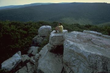
Catoctin Mountain vista (from Chimney Rock)Elevation 1,900 ft (579 m) Location Location Frederick County, Maryland / Loudoun County, Virginia, USA Range Blue Ridge Mountains of the Appalachian Mountain Range Coordinates 39°38′54″N 77°28′00″W / 39.64833°N 77.4666667°WCoordinates: 39°38′54″N 77°28′00″W / 39.64833°N 77.4666667°W Topo map USGS Blue Ridge Summit Climbing Easiest route road (restricted access) Catoctin Mountain, along with the geologically associated Bull Run Mountains, comprises the easternmost mountain ridge of the Blue Ridge Mountains, which are in turn a part of the Appalachian Mountains range. The ridge runs northeast/southwest for about 50 miles (80 km) departing from South Mountain near Emmitsburg, Maryland, and running south past Leesburg, Virginia, where it disappears into the Piedmont in a series of low-lying hills near Aldie. The ridge forms the eastern rampart of the Loudoun and Middletown valleys.
Contents
Geography
Catoctin Mountain traverses Frederick County, Maryland, and extends into northern Loudoun County, Virginia. It rises to its greatest elevation of 1,900 feet (580 m) above sea level just southwest of Cunningham Falls State Park[1] and is transected by gaps at Braddock Heights (Fairview Pass), Point of Rocks on the Potomac River and Clarke's Gap west of Leesburg, as well as several other unnamed passes in Maryland and Virginia. The mountain is much lower in elevation in Virginia, reaching its highest peak just south of the Potomac at Furnace Mountain (891 feet/271 m) and with only one peak above 800 feet (240 m) south of Leesburg.
From its northern terminus in Maryland headed south, the range is composed mainly of a single north-south running ridge with periodic low-lying gaps, though it does contain several spur ridges, most notably near its intersection with South Mountain at its northern terminus. Its ridge character continues south of the Potomac in northern Loudoun County, losing elevation, until just north of Leesburg, where the range widens into a broad plateau of undulating hills separated by deep stream valleys. The range reaches its widest point north of Goose Creek at nearly three miles. South of the creek the Catoctin vanishes into the Piedmont countryside near the northern terminus of the Bull Run Mountains at Aldie.
Recreation
A hiking trail, the Catoctin Trail, traverses the northern half (almost 27 miles (43 km)) of the range. It is maintained by the Potomac Appalachian Trail Club.
The trail starts at Gambrill State Park, which contains several shorter hiking and mountain biking trails as well as picnic pavilions, and continues north through the Frederick Municipal Forest to Cunningham Falls State Park and Catoctin Mountain Park. Both parks contain many shorter hiking trails and organized campgrounds.
The Catoctin Mountain Byway, a Maryland Scenic Byway, loops and weaves through the northern part of the range.
Names
The name of Catoctin Mountain follows the convention of referring to an entire mountainous ridge as a single "mountain" in situations where there is no single prominent peak. Nevertheless, it is still occasionally (and erroneously) called the "Catoctin Mountains".
According to the USGS, variant names of Catoctin Mountain include Kittochiny Mountains, Kittockton Mountain, Kittocton Mountain, and South Mountain. However, in Maryland, South Mountain and Catoctin Mountain are separate, roughly parallel, mountains.
The portion of the ridge directly west of Frederick, Maryland, is known locally as Braddock Mountain, and is signed as such where Interstate 70 crosses its summit, although the name is not recorded in the federal Geographic Names Information System. (The GNIS does, however, recognize the community of Braddock Heights, which is located there.)
Geology
The mountain, like much of the Blue Ridge/South Mountain in the immediate area, consists of Proterozoic Catoctin metabasaltic greenstone interspersed by metasedimentary white quartz and other phyllites and Precambrian basalt flows. The greenstone was originally uplifted during the Grenville Orogeny. Further uplifting during the Alleghenian Orogeny thrust the greenstone westward and interspersed it with the sedimentary rock deposited during the Paleozoic era.[2]
Flora and fauna
Much of the mountain, being shattered rock, is home to large populations of timber rattlesnakes. There are also black bears, turkeys, and deer, as well as vultures and raptors.
History
The name "Catoctin" probably derives from the Kittoctons, an American Indian tribe or clan which once lived between the mountain and the Potomac River. (Note that a local tradition asserts that Catoctin means "place of many deer" in an Indian language.)
Catoctin Mountain is perhaps best known as the site of Camp David, a mountain retreat for presidents of the United States. It was first used by President Franklin D. Roosevelt in the 1930s, who called it "Shangri-La". In the 1950s President Dwight Eisenhower renamed it Camp David, after his grandson David Eisenhower. The resort is extremely well guarded by the United States Secret Service, and only approved guests of the President are allowed into the retreat. Due to its proximity to Washington, D.C., and its beautiful mountain scenery, Camp David has proven to be a popular weekend "getaway" for many United States presidents, and approximately 1/3 of Catoctin Mountain Park can be closed to the public on short notice.
See also
- Catoctin Mountain Park
- Cunningham Falls State Park
- Frederick Municipal Forest (Frederick City Watershed)
- Gambrill State Park
- Sugarloaf Mountain (Maryland)
References
External links
Categories:- Geography of Frederick County, Maryland
- Geography of Loudoun County, Virginia
- Mountains of Maryland
- Mountains of Virginia
- Blue Ridge Mountains
Wikimedia Foundation. 2010.