Clarke's Gap

Clarke's Gap
Clarke's Gap
Clarke's Gap is located in Virginia
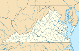
Location of Clarke's Gap in Virginia
Elevation 643 [1]
Traversed by

Virginia 7.svg Virginia Route 7


Virginia 9.svg Virginia Route 9
Location
Location Loudoun County, Virginia,  United States
Range Catoctin Mountain
Coordinates 39°08′24″N 77°36′34″W / 39.14°N 77.60944°W / 39.14; -77.60944Coordinates: 39°08′24″N 77°36′34″W / 39.14°N 77.60944°W / 39.14; -77.60944[1]


Clarke's Gap, also known as Clarks Gap, is a pass through Catoctin Mountain west of Leesburg, Virginia. The gap has an elevation of 643 feet (196 m). The gap is not a true wind gap, but rather a man-made railroad cut through a local saddle point between two ridges to the southeast and northwest created by the drainage of Dry Run to the east and an unnamed tributary of the Catoctin Creek to the west.

The original road between Alexandria and Winchester, known as Vestal's Gap or Braddock's Road passed through the gap beginning in the middle 18th century. Later, in the 1860s the Alexandria, Loudoun and Hampshire Railroad, predecessor of the Washington and Old Dominion Railroad was routed through the gap. The railroad christened the gap when it established a station there, naming it after a nearby landowner, Addison H. Clarke. Today, Dry Mill Road (Virginia State Route 699 (VA Route 699)) and the Washington and Old Dominion Trail still pass through the gap. VA Route 7 and VA Route 9 pass just to the north of the gap, through a man-made highway cut, which the Virginia Department of Transportation has mistakenly signed as "Clarks Gap".

References

  • Scheel, Eugene. Loudoun Discovered:Communities, Corners and Crossroads. Vol. 4. 2002, pp. 1–3.

Wikimedia Foundation. 2010.

Игры ⚽ Нужно сделать НИР?

Look at other dictionaries:

  • Clarks Gap — Infobox Mountain Pass Name = Clarks Gap Photo = Caption = Elevation = 650 ft./198 m. Location = Virginia USA Range = Catoctin Mountain Coordinates = Topographic Transversed by = Clarks Gap also known as Clarke s Gap, is a gap in the Catoctin… …   Wikipedia

  • Mind the gap — For other uses, see Mind the gap (disambiguation). A typical mind the gap warning sign found on the Toronto Subway and RT Mind the gap is a warning to train passengers to take caution while crossing the gap between the train door and the station… …   Wikipedia

  • Lewis & Clarke (music) — Infobox musical artist Name = Lewis Clarke Origin = flagicon|USA Delaware Water Gap, Pa Genre = Post Folk Neo Baroque Years active = 2003–present Label = La Société Expéditionnaire URL = [http://lewisandclarkemusic.com/ lewisandclarkemusic.com]… …   Wikipedia

  • Mind the gap — en la estación de Paddington. Mind the gap (trad. inglés, cuidado con el hueco) es una expresión utilizada en el metro de Londres (Reino Unido) desde 1969 para avisar a los pasajeros de la existencia de un hueco entre el andén y el vagón del tren …   Wikipedia Español

  • Mind The Gap — Photographie du Mind The Gap dans la station Charing Cross (métro de Londres) …   Wikipédia en Français

  • Mind the gap — Photographie du Mind The Gap dans la station Charing Cross (métro de Londres) …   Wikipédia en Français

  • Mind the gap — „Mind the gap“ am Bahnhof Paddington Mind the gap an der Bahnsteigkante Mind the gap („An die Lücke denken“) ist eine englische Phrase, die vor al …   Deutsch Wikipedia

  • Bruce B. G. Clarke — Infobox Military Person name= Colonel Bruce B.G. Clarke born= birth date|1943|1|26 placeofbirth= Ft. Benning, Georgia caption=COL Clarke taking command of the 2d Brigade, 1st Infantry Division in 1988 allegiance=flag|United States of America… …   Wikipedia

  • Snickers Gap — Infobox Mountain Pass Name = Snickers Gap Photo = Sickers Gap.jpg Caption = Snickers Gap as seen from across the Loudoun Valley on Mount Gilead Elevation = 1018 ft./325 m. Location = Virginia USA Range = Blue Ridge Mountains Coordinates =… …   Wikipedia

  • Ashby Gap — Infobox Mountain Pass Name = Ashby s Gap Photo = Ashbys gap.png|thumb|right|300px Caption = The view west into Ashby s Gap (2007) Elevation = 1100 ft./335 m. Location = Virginia USA Range = Blue Ridge Mountains Coordinates = Topographic… …   Wikipedia

Share the article and excerpts

Direct link
Do a right-click on the link above
and select “Copy Link”