- Northern Highland-American Legion State Forest
-
Northern Highland-American Legion State Forest Wisconsin State Forest 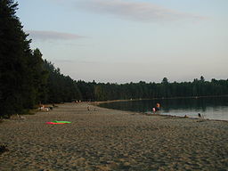 Beach at the Crystal Lake campground in Vilas County.
Country United States State Wisconsin Counties Iron, Oneida, Vilas Location Boulder Junction - coordinates 46°2′54″N 89°39′16″W / 46.04833°N 89.65444°W Area 223,283 acres (90,359.4 ha) Founded 1925 Management Wisconsin Department of Natural Resources IUCN category V - Protected Landscape/Seascape 

Northern Highland-American Legion State Forest is a Wisconsin state forest of more than 225,000 acres (910 km2) across Vilas, Oneida, and Iron counties in north-central Wisconsin. The state forest includes numerous lakes, rivers, and streams. The most prominent rivers are the Wisconsin, Flambeau, and Manitowish. The state forest supports a large variety of outdoor recreation activities including camping, hiking, snowmobiling, bicycling, boating, fishing, hunting, and birdwatching. In addition to recreational activities the state forest also hosts a number of research programs. The forest is a state-managed timber resource providing opportunities for commercial logging, individual firewood collection, and individual Christmas tree harvesting.
Camping
The forest offers abundant opportunities for campers with a wide range of facilities. The state forest hosts 18 campgrounds, 2 group camp areas, and 131 remote campsites. Additionally special permits can be obtained for backcounty backpack camping and deer-hunting camping.
External links
- Northern Highland-American Legion State Forest official website
Categories:- Protected areas of Iron County, Wisconsin
- Protected areas of Oneida County, Wisconsin
- Protected areas of Vilas County, Wisconsin
- Wisconsin state forests
- Protected areas established in 1925

Wikimedia Foundation. 2010.