- Borsele
Infobox Settlement
official_name = Borsele
mapsize = 280px
subdivision_type = Country
subdivision_name =Netherlands
subdivision_type1 = Province
subdivision_name1 =Zeeland
area_footnotes = (2006)
area_total_km2 = 194.42
area_land_km2 = 142.03
area_water_km2 = 52.39
population_as_of =1 January ,2007
population_note = Source: CBS, [http://statline.cbs.nl/ Statline] .
settlement_type = Municipality
population_total = 22355
population_density_km2 = 157
timezone = CET
utc_offset = +1
timezone_DST = CEST
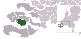
utc_offset_DST = +2Borsele (Pronunciation|240 Borsele.ogg) is a
municipality in the southwesternNetherlands onZuid-Beveland .The name of the municipality is spelled with a single s; the name of the eponymous village is spelled with double s.
Population centres
Baarland ,Borssele ,Driewegen ,Ellewoutsdijk ,'s-Gravenpolder ,'s-Heer Abtskerke ,'s-Heerenhoek ,Heinkenszand ,Hoedekenskerke ,Kwadendamme ,Lewedorp ,Nieuwdorp , Nisse,Oudelande andOvezande .Transport
The
Western Scheldt Tunnel is from Ellewoutsdijk toTerneuzen inZeeuws-Vlaanderen .External links
* [http://www.borsele.nl Official website]

Wikimedia Foundation. 2010.