- Charlestown Bridge
-
Charlestown Bridge 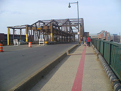
The Charlestown Bridge, looking north. The red line on the pavement is the Freedom Trail markingCarries vehicular and pedestrian traffic Crosses Charles River Locale Boston, Massachusetts Designer William Jackson Design plate girder bridge approaches with truss swing span[1] Construction begin 1898[1] Opened 1900[1] Preceded by Charles River Bridge (1786) Coordinates 42°22′08″N 71°03′36″W / 42.36889°N 71.06°WCoordinates: 42°22′08″N 71°03′36″W / 42.36889°N 71.06°W 

The Charlestown Bridge is the easternmost bridge on the Charles River in Boston, Massachusetts. The bridge formerly carried the southernmost stretch of Massachusetts Route 99, which now ends at Chelsea Street in Charlestown. It connects to Joe Tecce Way to the south and to Rutherford Avenue to the north. The bridge is also part of Boston's Freedom Trail. It is also called the North Washington Street bridge.
Contents
History
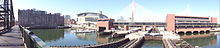 A panoramic view from the bridge showing the TD Garden, Leonard P. Zakim Bunker Hill Bridge, and the Charles River Dam
The first government-sanctioned ferry crossing of the Charles was chartered at this location in 1630. It was operated by various individuals until it was given to Harvard College in perpetuity in 1640, to support it financially.[2]
The first bridge on this site was known as the Charles River Bridge, chartered in 1785 and opened on June 17, 1786. As a condition of chartering the bridge, a sum of £200 was paid annually to Harvard College to compensate for the lost ferry income. The bridge was privately built and operated, with tolls producing profits for the investors during the charter period, after the initial expense was paid off. In 1792, the West Boston Bridge was chartered, connecting West Boston to Cambridge. In compensation, the legislature extended the charter period of the Charles River Bridge by 30 years, but the unpopular double tolls on Sundays were eliminated.[3] Traffic to the bridge was facilitated by the laying out of the Medford Turnpike in 1803.
When the Warren Bridge was chartered in 1828 in a location extremely close to the Charles River Bridge, the investors filed a lawsuit which eventually reached the United States Supreme Court as Charles River Bridge v. Warren Bridge.
The current bridge was built in 1900 under chief engineer William Jackson. It carried the Charlestown Elevated until the railway was demolished and re-routed in 1975.
See also
References
- ^ a b c Tsipis, Yanni (2004) Boston's Bridges Images of America Charleston, South Carolina: Arcadia Publishing pp. 13–16 ISBN 0-7385-3571-0
- ^ http://www.kellscraft.com/EventsBoston/EventsBoston05.html
- ^ Bacon's dictionary of Boston by Edwin Monroe Bacon and George Edward Ellis. p. 69.
External links
Crossings of the Charles River Upstream
Charles River DamCharlestown Bridge Downstream
Boston HarborCategories:- Bridges in Boston, Massachusetts
- Landmarks in Boston, Massachusetts
- Railroad bridges in Massachusetts


Wikimedia Foundation. 2010.