- Drakenstein Local Municipality
-
Drakenstein Local Municipality
Drakenstein Plaaslike Munisipaliteit
UMasipala weNgingqi yaseDrakenstein— Local municipality — Location in the Western Cape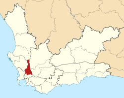
Coordinates (Paarl Civic Centre): 33°44′14″S 18°58′5″E / 33.73722°S 18.96806°ECoordinates: 33°44′14″S 18°58′5″E / 33.73722°S 18.96806°E Country  South Africa
Province Western Cape District Cape Winelands Seat Paarl Wards 31 Government - Type Municipal council - Mayor Charmaine Manuel (ANC) Area[1] - Total 1,538 km2 (593.8 sq mi) Population (2007)[2] - Total 217,089 - Density 141.2/km2 (365.6/sq mi) - Households 51,614 Population groups[3] - Coloured 64.75% - Black African 19.56% - White 14.86% - Indian or Asian 0.84% Languages[4] - Afrikaans 76.67% - Xhosa 18.88% - English 3.39% Time zone South African Standard Time (UTC+2) Municipal code WC023 Website www.drakenstein.gov.za Drakenstein Municipality is a local municipality located within the Cape Winelands District Municipality, in the Western Cape province of South Africa. As of 2007, it had a population of 217,089.[2] Its municipality code is WC023.
Contents
Government
Drakenstein is divided into thirty-one wards, with a total of sixty one councillors.
After the local government elections of 2006, a coalition was formed by the African National Congress (ANC) and the Independent Democrats (ID), and Charmaine Manuel of the ANC was elected as executive mayor with Wilhelm Nothnagel of the ID as deputy mayor. In April of 2007 the ID broke the coalition, and formed a new coalition with the Democratic Alliance (DA); Koos Louw of the DA was elected mayor while Nothnagel remained deputy mayor. During the floor crossing period in September 2007, seven councillors (five from the ID, including Nothnagel) defected to the ANC, giving the ANC an outright majority (32 of 61 seats) on the council. Charmaine Manuel was re-elected as mayor, with Nothnagel continuing as deputy.
In the 2011 local government elections the DA managed to turn the tables, and obtained an outright majority on the council, holding 35 seats out of 61.
Mayors
- Charmaine Manuel (September 2007 - Present) (ANC)
- Koos Louw (April 2007 - September 2007) (DA)
- Charmaine Manuel (March 2006 - April 2007) (ANC)
Geography
The municipality has a total area of 1,538 square kilometres (594 sq mi).[1]
The Drakenstein Municapilty consists of the towns of Paarl, Wellington and Saron, Western Cape, and the surrounding villages and farms.
Adjacent municipalities
- Bergrivier Local Municipality, West Coast District Municipality (north)
- Witzenberg Local Municipality (northeast)
- Breede Valley Local Municipality (southeast)
- Stellenbosch Local Municipality (south)
- City of Cape Town (southwest)
- Swartland Local Municipality, West Coast District Municipality (northwest)
Demographics
As of the census of 2001, there are 194,419 people and 44,409 households residing in the municipality. The population density is 126.41/km². The density of households is 28.87/km². The racial makeup of the municipality is Black African 21.35%, Coloured 63.75%, Indian/Asian 0.3%, and White 14.6%.
11.4% of all households are made up of individuals. The average household size is 4.38.
In the municipality the population is spread out with 28.5% under the age of 15, 19.7% from 15 to 24, 32.7% from 25 to 44, 14.7% from 45 to 64, and 4.4% who are 65 years of age or older. The median age is 26 years. For every 100 females there are 96.0 males. For every 100 females age 18 and over, there are 93.2 males.
In the municipality 76.7% of residents speak Afrikaans at home, 3.4% speak English, 0.0% speak Ndebele, 18.9% speak Xhosa, 0.0% speak Zulu, 0.0% speak Northern Sotho, 0.6% speak Sotho, 0.0% speak Tswana, 0.0% speak Swati, 0.0% speak Venda, and 0.0% speak Tsonga. 0.2% of the population speaks a non-official language at home.
90.5% of residents are Christian, 5.8% have no religion, 1.8% are Muslim, 0.0% are Jewish, and 0.0% are Hindu. 1.9% have other or undetermined beliefs.
6.4% of residents aged 20 and over have received no schooling, 19.3% have had some primary school, 9.1% have completed only primary school, 35.1% have had some high school education, 20.9% have finished only high school, and 9.2% have an education higher than the high school level. Overall, 30.1% of residents have completed high school.
57.7% of housing units have a telephone and/or cell-phone in the dwelling, 39.2% have access to a phone nearby, and 3.1% have access that is not nearby or no access. 88.7% of households have a flush or chemical toilet. 78.1% have refuse removed by the municipality at least once a week and 1.7% have no rubbish disposal. 65.9% have running water inside their dwelling, 86.9% have running water on their property, and 97.9% have access to running water. 78.9% of households use electricity for cooking, 75.2% for heating, and 86.8% for lighting. 76.7% of households have a radio, 74.8% have a television, 13.6% own a computer, 74.0% have a refrigerator, and 36.2% have a cell-phone.
14.7% of the population aged 15-65 is unemployed. Of the unemployed persons, 48.7% are Black African, 49.0% are Coloured, 0.2% are Indian/Asian, and 2.2% are White. 32.5% of Black Africans are unemployed, 11.5% of Coloureds, 10.1% of Indians/Asians, and 2.1% of Whites.
The median annual income of working adults aged 15-65 is R 15 553 ($2,298). Males have a median annual income of R 17 722 ($2,622) versus R 12 254 ($1,813) for females. The median annual income by race is R 10 851 ($1,606) for Black Africans, R 13 352 ($1,976) for Coloureds, R 29 325 ($4,339) for Indians/Asians, and R 60 313 ($8,925) for Whites. The annual income distribution in Drakenstein Municipality is:
- No income 2.0%
- R 12 – R 4 800 ($2 - $721) 6.1%
- R 4 812 – R 9 600 ($723 - $1,443) 26.1%
- R 9 612 – R 19 200 ($1,445 – $2,886) 25.5%
- R 19 212 – R 38 400 ($2,888 - $5,772) 18.7%
- R 38 412 – R 76 800 ($5,774 - $11,543) 12.3%
- R 76 812 – R 153 600 ($11,545 - $23,087) 6.2%
- R 153 612 – R 307 200 ($23,089 - $46,174) 2.1%
- R 307 212 – R 614 400 ($46,176 - $92,348) 0.6%
- R 614 412 or more ($92,350+) 0.5%
Statistics South Africa Census 2001
Cities and towns
- Gouda
- Mbekweni
- Paarl
- Saron
- Wellington
References
- ^ a b "Drakenstein Local Municipality". Municipal Demarcation Board. http://www.demarcation.org.za/PortalPages/info_1.aspx?type=Local&Prov=Western%20Cape&code=WC023. Retrieved 19 June 2010.
- ^ a b "Community Survey, 2007: Basic Results Municipalities" (PDF). Statistics South Africa. http://www.statssa.gov.za/Publications/P03011/P030112007.pdf. Retrieved 19 June 2010.
- ^ "Table: Community Survey 2007 by municipality, population group, gender and age group". Community Survey 2007 interactive data. Statistics South Africa. http://www.statssa.gov.za/timeseriesdata/pxweb2006/Dialog/varval.asp?ma=agegrp_gender__popgrp&ti=Community+Survey+2007+by+municipality%2C+population+group%2C+gender+and+age+group&path=../Database/South%20Africa/Community%20Survey%202007/Persons/Municipality/&lang=1. Retrieved 19 June 2010.
- ^ "Table: Census 2001 by municipalities, language, population group and gender". Census 2001 interactive data. Statistics South Africa. http://www.statssa.gov.za/timeseriesdata/pxweb2006/Dialog/varval.asp?ma=Language%20by%20municpality&ti=Table%3A+Census+2001+by+municipalities%2C+language%2C+population+group+and++gender.&path=../Database/South%20Africa/Population%20Census/Census%202001%20-%20NEW%20Demarcation%20boundaries%20as%20at%209%20December%202005/Municipality%20level%20-%20Persons/&lang=1. Retrieved 19 June 2010.
External links

Witzenberg • Drakenstein • Stellenbosch • Breede Valley • Langeberg
Cities and towns Ashton • Bonnievale • Ceres • Chicago • De Doorns • Denneburg • Franschhoek • Gouda • Kayamandi • Klapmuts • Kylemore • Languedoc • McGregor • Montagu • Op-die-Berg • Paarl • Pniel • Prince Alfred Hamlet • Rawsonville • Robertson • Robertsvlei • Rozendal • Saron • Stellenbosch • Touws River • Tulbagh • Wellington • Wemmershoek • Wolseley • Worcester
Metropolitan
municipality
District
and local
municipalitiesCategories:- Local Municipalities of Cape Winelands


Wikimedia Foundation. 2010.