- Mellott, Indiana
-
Mellott — Town — Mellott seen from the northeast along CR 300 North Fountain County's location in Indiana
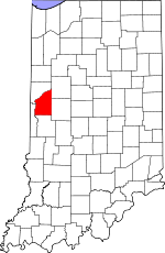 Mellott's location in Fountain County
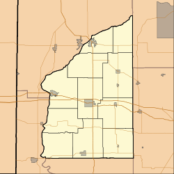
 Mellott
Coordinates: 40°9′50″N 87°8′53″W / 40.16389°N 87.14806°WCoordinates: 40°9′50″N 87°8′53″W / 40.16389°N 87.14806°W Country United States State Indiana County Fountain Township Richland Area – Total 0.2 sq mi (0.4 km2) – Land 0.2 sq mi (0.4 km2) – Water 0.0 sq mi (0.0 km2) Elevation 728 ft (222 m) Population (2010) – Total 197 – Density 1,317.8/sq mi (508.8/km2) Time zone Eastern (EST) (UTC-5) – Summer (DST) EDT (UTC-4) ZIP code 47958 Area code(s) 765 FIPS code 18-48294[1] GNIS feature ID 0438973[2] Mellott is a town in Richland Township, Fountain County, Indiana, United States. The population was 197 at the 2010 census.
Geography
Mellott is located at 40°9′50″N 87°8′53″W / 40.16389°N 87.14806°W (40.163921, -87.147964)[3].
According to the United States Census Bureau, the town has a total area of 0.2 square miles (0.52 km2), all of it land. Mellott was named for John Mellott the postmaster he was born in Beallsville, Ohio
Demographics
As of the census[1] of 2000, there were 207 people, 87 households, and 60 families residing in the town. The population density was 1,317.8 people per square mile (499.5/km²). There were 94 housing units at an average density of 598.4 per square mile (226.8/km²). The racial makeup of the town was 99.52% White and 0.48% Native American. Hispanic or Latino of any race were 1.45% of the population.
There were 87 households out of which 29.9% had children under the age of 18 living with them, 50.6% were married couples living together, 10.3% had a female householder with no husband present, and 29.9% were non-families. 29.9% of all households were made up of individuals and 19.5% had someone living alone who was 65 years of age or older. The average household size was 2.38 and the average family size was 2.89.
In the town the population was spread out with 28.0% under the age of 18, 3.4% from 18 to 24, 29.5% from 25 to 44, 19.8% from 45 to 64, and 19.3% who were 65 years of age or older. The median age was 37 years. For every 100 females there were 89.9 males. For every 100 females age 18 and over, there were 77.4 males.
The median income for a household in the town was $29,375, and the median income for a family was $37,500. Males had a median income of $33,750 versus $25,000 for females. The per capita income for the town was $19,694. About 5.9% of families and 11.1% of the population were below the poverty line, including 21.9% of those under the age of eighteen and 15.2% of those sixty five or over.
References
- ^ a b "American FactFinder". United States Census Bureau. http://factfinder.census.gov. Retrieved 2008-01-31.
- ^ "US Board on Geographic Names". United States Geological Survey. 2007-10-25. http://geonames.usgs.gov. Retrieved 2008-01-31.
- ^ "US Gazetteer files: 2010, 2000, and 1990". United States Census Bureau. 2011-02-12. http://www.census.gov/geo/www/gazetteer/gazette.html. Retrieved 2011-04-23.
Municipalities and communities of Fountain County, Indiana Cities 
Towns Hillsboro | Kingman | Mellott | Newtown | Veedersburg | Wallace
Townships Unincorporated
communitiesAylesworth | Cates | Centennial | Coal Creek | Fountain | Graham | Harveysburg | Layton | Riverside | Rob Roy | Roberts | Silverwood | Steam Corner | Stone Bluff | Vine | Yeddo
Categories:- Populated places in Fountain County, Indiana
- Towns in Indiana


Wikimedia Foundation. 2010.