- Oklahoma State Highway 80
-
State Highway 80
Route information Maintained by ODOT Length: 20.4 mi (32.8 km) Major junctions south end: 
 US-62/SH-10 in Ft. Gibson
north end:  SH-51 in Hulbert
Highway system Oklahoma State Highways
Oklahoma turnpike system←  SH-79
SH-79US-81  →
→State Highway 80 is a north–south state highway in eastern Oklahoma. It runs from Ft. Gibson in Muskogee County to Hulbert in Cherokee County. It is 20.4 miles[1] (33 km) long and has one lettered spur route, SH-80A.
Contents
Route description
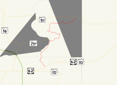
SH-80 begins at US-62/SH-10 just south of Ft. Gibson. After heading through Ft. Gibson, it enters Cherokee County. It roughly parallels the Cherokee/Wagoner County line before meeting the east end of State Highway 251A. It then heads east before curving back north and zig-zagging to its northern end with SH-51.
Junction list
County Location Mile[1] Destinations Notes Muskogee Ft. Gibson 0.0 US-62/SH-10Southern terminus 1.9  SH-80A
2.2 SH-80ACherokee 7.0  SH-251A
Hulbert 20.4 SH-511.000 mi = 1.609 km; 1.000 km = 0.621 mi SH-80A

SH-80A is an alternate route of SH-80 through the east side of Ft. Gibson. It is a half mile[2] (0.8 km) in length. It connects to SH-80 at both ends.
References
- ^ a b Stuve, Eric. "OK-80". OKHighways. http://www.okhighways.com/ok80.html. Retrieved 2007-08-10.
- ^ Stuve, Eric. "OK-80a". OKHighways. http://www.okhighways.com/ok80a.html. Retrieved 2007-08-10.
External links
Categories:- State highways in Oklahoma


Wikimedia Foundation. 2010.