- Mitchellville, Arkansas
-
Mitchellville, Arkansas — City — Location in Desha County and the state of Arkansas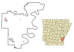
Coordinates: 33°54′19″N 91°29′54″W / 33.90528°N 91.49833°WCoordinates: 33°54′19″N 91°29′54″W / 33.90528°N 91.49833°W Country United States State Arkansas County Desha Area – Total 0.1 sq mi (0.4 km2) – Land 0.1 sq mi (0.4 km2) – Water 0 sq mi (0 km2) Elevation 161 ft (49 m) Population (2010) – Total 360 – Density 2,331/sq mi (900/km2) Time zone Central (CST) (UTC-6) – Summer (DST) CDT (UTC-5) ZIP code 71639 Area code(s) 870 FIPS code 05-46190 GNIS feature ID 0058200 Mitchellville is a city in Desha County, Arkansas, United States. The population was 360 at the 2010 census.[1]
Contents
Geography
Mitchellville is located at 33°54′19″N 91°29′54″W / 33.905253°N 91.498277°W.[2]
According to the United States Census Bureau, the city has a total area of 0.3 square miles (0.78 km2), all of it land.
Demographics
As of the census[3] of 2000, there were 497 people, 180 households, and 129 families residing in the city. The population density was 3,322.5 people per square mile (1,279.3/km²). There were 197 housing units at an average density of 1,316.9/sq mi (507.1/km²). The racial makeup of the city was 0.40% White, 98.19% Black or African American, 0.20% Asian, 1.01% from other races, and 0.20% from two or more races. 1.21% of the population were Hispanic or Latino of any race.
There were 180 households out of which 38.9% had children under the age of 18 living with them, 30.6% were married couples living together, 35.0% had a female householder with no husband present, and 28.3% were non-families. 26.1% of all households were made up of individuals and 12.8% had someone living alone who was 65 years of age or older. The average household size was 2.76 and the average family size was 3.33.
In the city the population was spread out with 38.0% under the age of 18, 9.3% from 18 to 24, 18.7% from 25 to 44, 20.9% from 45 to 64, and 13.1% who were 65 years of age or older. The median age was 29 years. For every 100 females there were 75.6 males. For every 100 females age 18 and over, there were 64.7 males.
The median income for a household in the city was $17,625, and the median income for a family was $19,500. Males had a median income of $20,000 versus $16,042 for females. The per capita income for the city was $8,680. About 39.2% of families and 43.7% of the population were below the poverty line, including 56.9% of those under age 18 and 53.8% of those age 65 or over.
Education
The Dumas School District serves Mitchellville.[4]
References
- ^ "Race, Hispanic or Latino, Age, and Housing Occupancy: 2010 Census Redistricting Data (Public Law 94-171) Summary File (QT-PL), Mitchellville city, Arkansas". U.S. Census Bureau, American FactFinder 2. http://factfinder2.census.gov. Retrieved August 15, 2011.
- ^ "US Gazetteer files: 2010, 2000, and 1990". United States Census Bureau. 2011-02-12. http://www.census.gov/geo/www/gazetteer/gazette.html. Retrieved 2011-04-23.
- ^ "American FactFinder". United States Census Bureau. http://factfinder.census.gov. Retrieved 2008-01-31.
- ^ "Maintenance & Transportation Department." Dumas School District. Retrieved on March 6, 2011.
Municipalities and communities of Desha County, Arkansas Cities Arkansas City | Dumas | McGehee | Mitchellville | Tillar‡ | Watson
Town Unincorporated
communitiesBack Gate | Halley | Kelso | Pea Ridge | Pickens | Rohwer | Snow Lake | Trippe Junction
Ghost towns Napoleon | Wellington
Footnotes ‡This populated place also has portions in an adjacent county or counties
Categories:- Cities in Arkansas
- Populated places in Desha County, Arkansas
- Populated places in Arkansas with African American majority populations


Wikimedia Foundation. 2010.