- Manawatu Plains
-
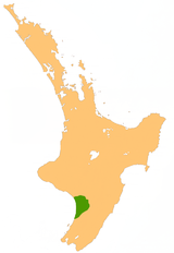 Location of the Manawatu Plains
Some of the most fertile land in the southwestern North Island of New Zealand is located on the floodplains of the Manawatu and Rangitikei Rivers, in an area known as the Manawatu Plains.
Stretching from the northern Horowhenua around Levin in the south to Marton in the north, this great triangular area of low-lying land extends inland from the South Taranaki Bight almost as far as Ashhurst at the mouth of the Manawatu Gorge, and covers an area of around 1000 km².
In the south, around Lake Horowhenua, the plains were once an extensive wetland, which has been largely drained and turned into profitable dairy farming land. There are conservation moves in progress to restore some of these wetlands to their former state.
Further north, the plains provide the basis for the economy which drives the city of Palmerston North and the towns of Foxton, Feilding and Bulls, all of which rely on the agricultural dollar to an extent.
As floodplains, the land is not always entirely dry land, and although the area receives slightly below the national average rainfall, floods can occur, as happened most recently around the township of Tangimoana in early 2004.
Manawatu River Source: Ruahine Range — Flows into: South Taranaki BightAdministrative areas Hawke's Bay Region · Manawatu-Wanganui Region · Central Hawke's Bay District · Tararua District · Manawatu District · Palmerston North City · Horowhenua DistrictTowns and settlements (upstream to downstream) Norsewood · Ormondville · Dannevirke · Kumeroa · Woodville · Ashhurst · Palmerston North · Tokomaru · Shannon · Foxton · Foxton BeachMajor tributaries (upstream to downstream by confluence) Other features (upstream to downstream) Manawatu Gorge · Manawatu PlainsLongest New Zealand rivers 1: Waikato · 2: Clutha · 3: Whanganui · 4: Taieri · 5: Rangitikei · 6: Mataura · 7: Waiau (Southland) · 8: Clarence · 9: Waitaki · 10: OretiCategories:- Manawatu-Wanganui Region
- Plains of New Zealand

Wikimedia Foundation. 2010.