- Manawatu Gorge
-
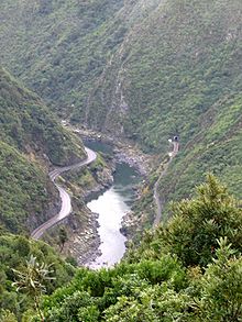 Manawatu Gorge viewed from a lookout on the Manawatu Gorge Track
The Manawatu Gorge (in Maori Te Apiti, meaning 'The Narrow Passage') runs between the Ruahine and Tararua Ranges of the North Island of New Zealand, linking the Manawatu and Hawke's Bay regions. It lies to the northeast of Palmerston North - its western end is near the small town of Ashhurst, its eastern end is close to the town of Woodville.
The Manawatu Gorge is significant because, unlike most gorges, the Manawatu River is a water gap, that is it runs directly through the surrounding ranges from one side to the other. This was caused by the ranges moving upwards at the same time as the gorge was eroded by the river, instead of the more usual erosion of an already existing range.
The road through the Manawatu Gorge, State Highway 3, is on the south side, and was completed in 1872. It is the primary link between the two sides of the lower North Island. It is sometimes closed by slips, especially in inclement weather. Alternative road routes cross the ranges on both the northern and southern sides.
A rail connection was established on the northern side of the gorge; it was completed in 1891 and is now part of the Palmerston North - Gisborne Line.
A tramping track, the Manawatu Gorge Track, runs parallel to the gorge on the south side through native bush.
The Old Gorge Cemetery lies on the north side of the Manawatu Gorge. Public access is available, but the cemetery was closed many years ago to further burials. The road is located just a few kilometres out of Woodville on the north side of the gorge.
See also
External links
Manawatu River Source: Ruahine Range — Flows into: South Taranaki Bight Administrative areas Hawke's Bay Region · Manawatu-Wanganui Region · Central Hawke's Bay District · Tararua District · Manawatu District · Palmerston North City · Horowhenua DistrictTowns and settlements (upstream to downstream) Norsewood · Ormondville · Dannevirke · Kumeroa · Woodville · Ashhurst · Palmerston North · Tokomaru · Shannon · Foxton · Foxton BeachMajor tributaries (upstream to downstream by confluence) Other features (upstream to downstream) Manawatu Gorge · Manawatu PlainsLongest New Zealand rivers 1: Waikato · 2: Clutha · 3: Whanganui · 4: Taieri · 5: Rangitikei · 6: Mataura · 7: Waiau (Southland) · 8: Clarence · 9: Waitaki · 10: Oreti
Coordinates: 40°19′06″S 175°47′53″E / 40.3184°S 175.7980°ECategories:- Manawatu-Wanganui Region
- Canyons and gorges of New Zealand
- Water gaps

Wikimedia Foundation. 2010.