- Maryland Route 364
-
Maryland Route 364
Dividing Creek Road 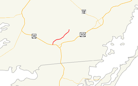
Maryland Route 364 highlighted in redRoute information Maintained by MDSHA Length: 5.43 mi[1][2] (8.74 km) Major junctions South end:  US 13 in West Pocomoke
North end: Nassawango Road near Pocomoke State Forest Location Counties: Somerset, Worcester Highway system Maryland highway system
Interstate • US • State • Minor • Former • Turnpikes←  MD 363
MD 365  →
→Maryland Route 364 (MD 364) is a state highway in the U.S. state of Maryland. Known as Dividing Creek Road, the state highway runs 5.43 miles (8.74 km) from U.S. Route 13 (US 13) in West Pocomoke north to Pocomoke State Forest. MD 364 parallels the Pocomoke River and provides access to Pocomoke River State Park. The state highway was mostly constructed in the early 1930s.
Contents
Route description
MD 364 begins at an intersection with US 13 (Ocean Highway) in West Pocomoke. The highway continues on the other side of the intersection as US 13 Business toward Pocomoke City.[3] MD 364 heads north as a two-lane road, passing both ends of Pocomoke River Road.[1] After intersecting Courthouse Hill Road, the state highway crosses Dividing Creek and enters Worcester County.[1] MD 364 passes through more farmland, then reaches its northern terminus just beyond Cellar House Road on the edge of Pocomoke State Forest.[2] The highway continues as Nassawango Road, a county highway that passes through the state forest and provides access to the Milburn Landing unit of Pocomoke River State Park.[3][4]
History
The first part of MD 364 to be paved was a segment north of Dividing Creek, which was built as a state aid road between 1912 and 1915.[5] By 1927, another segment was built from US 13 halfway to Dividing Creek.[6] The state aid road was partially reconstructed and the remainder of the highway was under construction by 1933, with MD 364 completed in 1935.[7][8][9]
Junction list
County Location Mile
[1][2]Destinations Notes Somerset West Pocomoke 0.00  US 13 Bus. south (Market Street) – Pocomoke City
Southern terminus US 13 (Ocean Highway) – Salisbury, Norfolk0.09 Pocomoke River Road Former MD 580 0.84 Pocomoke River Road Worcester Pocomoke State Forest 5.43 Nassawango Road north – Pocomoke River State Park Northern terminus 1.000 mi = 1.609 km; 1.000 km = 0.621 mi References
- ^ a b c d "Highway Location Reference: Somerset County" (PDF). Maryland State Highway Administration. 2009. http://www.marylandroads.com/Location/2009_SOMERSET.pdf. Retrieved 2010-10-23.
- ^ a b c "Highway Location Reference: Worcester County" (PDF). Maryland State Highway Administration. 2009. http://www.marylandroads.com/Location/2009_WORCESTER.pdf. Retrieved 2010-10-23.
- ^ a b Google, Inc. Google Maps – Maryland Route 364 (Map). Cartography by Google, Inc. http://maps.google.com/maps?f=d&source=s_d&saddr=Dividing+Creek+Rd&daddr=Nassawango+Rd&hl=en&geocode=FWQJRQIdnMt--w%3BFYD2RQIdqdB_-w&mra=ls&sll=38.082994,-75.569201&sspn=0.015505,0.038581&ie=UTF8&t=h&z=13. Retrieved 2010-04-01.
- ^ "Pocomoke River State Park". Maryland Department of Natural Resources. 2010-03-31. http://www.dnr.state.md.us/publiclands/eastern/pocomokeriver.html. Retrieved 2010-04-01.
- ^ Report of the State Roads Commission of Maryland. 1912-1915. Baltimore: Maryland State Roads Commission. May 1916. p. 126. http://www.archive.org/details/annualreportsofs1912mary. Retrieved 2010-04-01.
- ^ Maryland Geological Survey. Map of Maryland: Showing State Road System and State Aid Roads (Map) (1927 ed.).
- ^ Maryland Geological Survey. Map of Maryland Showing State Road System: State Aid Roads and Improved County Road Connections (Map) (1933 ed.).
- ^ Maryland Geological Survey. Map of Maryland Showing State Road System: State Aid Roads and Improved County Road Connections (Map) (1935 ed.).
- ^ Report of the State Roads Commission of Maryland. 1931-1934. Baltimore: Maryland State Roads Commission. 1934-12-28. pp. 362–363. http://www.archive.org/details/reportofstateroa1931mary. Retrieved 2010-04-01.
External links
Roads in Somerset County, Maryland State highways 
U.S. Highways Roads in Worcester County, Maryland State highways 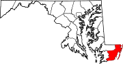
U.S. Highways Categories:- State highways in Maryland
- Roads in Somerset County, Maryland
- Roads in Worcester County, Maryland


Wikimedia Foundation. 2010.