- Maryland Route 376
-
Maryland Route 376
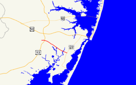
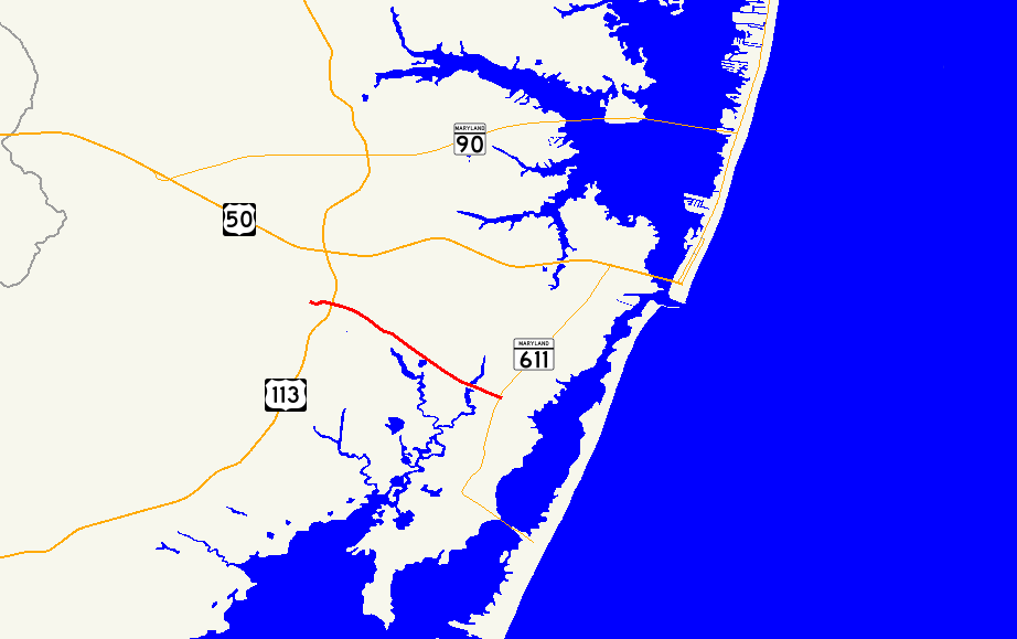
Maryland Route 376 highlighted in redRoute information Maintained by MDSHA Length: 4.56 mi[1] (7.34 km) Major junctions West end:  MD 818 in Berlin
 US 113 in Berlin
East end:  MD 611 in Lewis Corner
Location Counties: Worcester Highway system Maryland highway system
Interstate • US • State • Minor • Former • Turnpikes←  MD 375
MD 377  →
→Maryland Route 376 (MD 376) is a state highway in the U.S. state of Maryland. Known for most of its length as Assateague Road, the state highway runs 4.56 miles (7.34 km) from MD 818 in Berlin east to MD 611 in Lewis Corner. MD 376 connects Berlin with communities on the Sinepuxent Neck and, in conjunction with MD 611, connects Berlin with Assateague Island National Seashore. The state highway was constructed from Berlin in the second half of the 1920s and the early 1930s.
Contents
Route description
MD 376 begins at an intersection with MD 818 (Main Street) in Berlin. After intersecting the southern end of unsigned MD 377 (Williams Street), the state highway heads east as two-lane Bay Street east to U.S. Route 113 (Worcester Highway) and leaves the town of Berlin upon traversing Hudson Branch. The highway's name changes to Assateague Road and MD 376 continues southeast through farmland and forest, intersecting Sinepuxent Road after crossing Trappe Creek. The state highway spans Ayres Creek before reaching its eastern terminus at MD 611 (Stephen Decatur Highway) in Lewis Corner.[1][2]
History
MD 376 was paved from the Berlin town line to just east of Trappe Creek in 1924. Bay Street within Berlin was paved in 1925.[3][4] By 1930, MD 376 had been completed east almost to Ayres Creek.[5] The state highway was complete to Lewis Corner by 1933.[6][7]
Junction list
The entire route is in Worcester County.
Location Mile[1] Destinations Notes Berlin 0.00 MD 818 (Main Street)Western terminus 0.01 MD 377 north (Williams Street)MD 377 is unsigned 0.42 US 113 (Worcester Highway) – Snow Hill, Selbyville, DELewis Corner 4.56 MD 611 (Stephen Decatur Highway) – West Ocean City, Assateague Island National SeashoreEastern terminus 1.000 mi = 1.609 km; 1.000 km = 0.621 mi References
- ^ a b c "Highway Location Reference: Worcester County" (PDF). Maryland State Highway Administration. 2009. http://www.marylandroads.com/Location/2009_WORCESTER.pdf. Retrieved 2010-10-24.
- ^ Google, Inc. Google Maps – Maryland Route 376 (Map). Cartography by Google, Inc. http://maps.google.com/maps?f=d&source=s_d&saddr=maryland+376+and+maryland+818+berlin,+md&daddr=maryland+376+and+maryland+611+west+ocean+city,+md&hl=en&geocode=FRDJSAIdZUCE-ynLvegq6Sa5iTEUstGacTBHSw%3BFUpBSAIde0eF-ymD6G0Cqyi5iTHtCebOSunLoA&mra=ls&sll=38.335652,-75.11304&sspn=0.007136,0.02105&ie=UTF8&ll=38.30745,-75.185108&spn=0.056575,0.1684&t=h&z=13. Retrieved 2010-04-09.
- ^ Report of the State Roads Commission of Maryland. 1924-1926. Baltimore: Maryland State Roads Commission. January 1927. pp. 28, 100. http://www.archive.org/details/annualreportsofs1924mary. Retrieved 2010-04-09.
- ^ Maryland Geological Survey. Map of Maryland: Showing State Road System and State Aid Roads (Map) (1927 ed.).
- ^ Maryland Geological Survey. Map of Maryland Showing State Road System: State Aid Roads and Improved County Road Connections (Map) (1930 ed.).
- ^ Report of the State Roads Commission of Maryland. 1927-1930. Baltimore: Maryland State Roads Commission. 1930-10-01. p. 235. http://www.archive.org/details/annualreportsofs1927mary. Retrieved 2010-04-01.
- ^ Maryland Geological Survey. Map of Maryland Showing State Road System: State Aid Roads and Improved County Road Connections (Map) (1933 ed.).
External links
Roads in Worcester County, Maryland State highways 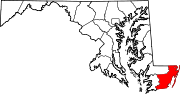
U.S. Highways Categories:- State highways in Maryland
- Roads in Worcester County, Maryland


Wikimedia Foundation. 2010.