- Chiemsee (municipality)
-
Chiemsee 

 ChiemseeLocation of Chiemsee within Rosenheim district
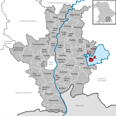
Coordinates 47°52′N 12°25′E / 47.86667°N 12.41667°ECoordinates: 47°52′N 12°25′E / 47.86667°N 12.41667°E Administration Country Germany State Bavaria Admin. region Upper Bavaria District Rosenheim Municipal assoc. Breitbrunn am Chiemsee Mayor Georg Huber Basic statistics Area 2.57 km2 (0.99 sq mi) Elevation 523 m (1716 ft) Population 311 (31 December 2010)[1] - Density 121 /km2 (313 /sq mi) Other information Time zone CET/CEST (UTC+1/+2) Licence plate RO Postal code 83256 Area code 08054 Website www.vg-breitbrunn.de Chiemsee is a municipality in the district of Rosenheim in Bavaria in Germany, named after the lake Chiemsee. It is Bavaria's smallest municipality by area and the second smallest (after Balderschwang) by population.
 Frauenchiemsee in winter
The municipal area comprises not the lake itself but the islands of Herrenchiemsee (Herreninsel) with its Palaces, Frauenchiemsee and the uninhabited Krautinsel. While the island of Herrenchiemsee with 2.38 km2 (0.92 sq mi) is by far the largest, most of Chiemsee's inhabitants live on 0.15 km2 (0.058 sq mi) Frauenchiemsee.
References
- ^ "Fortschreibung des Bevölkerungsstandes" (in German). Bayerisches Landesamt für Statistik und Datenverarbeitung. 31 December 2010. https://www.statistikdaten.bayern.de/genesis/online?language=de&sequenz=tabelleErgebnis&selectionname=12411-009r&sachmerkmal=QUASTI&sachschluessel=SQUART04&startjahr=2010&endjahr=2010.
Albaching | Amerang | Aschau im Chiemgau | Babensham | Bad Aibling | Bad Endorf | Bad Feilnbach | Bernau am Chiemsee | Brannenburg | Breitbrunn am Chiemsee | Bruckmühl | Chiemsee | Edling | Eggstätt | Eiselfing | Feldkirchen-Westerham | Flintsbach | Frasdorf | Griesstätt | Großkarolinenfeld | Gstadt am Chiemsee | Halfing | Höslwang | Kiefersfelden | Kolbermoor | Neubeuern | Nußdorf am Inn | Oberaudorf | Pfaffing | Prien am Chiemsee | Prutting | Ramerberg | Raubling | Riedering | Rimsting | Rohrdorf | Rott am Inn | Samerberg | Schechen | Schonstett | Söchtenau | Soyen | Stephanskirchen | Tuntenhausen | Vogtareuth | Wasserburg am InnCategories:- Municipalities in Bavaria
- Rosenheim district
- Upper Bavaria geography stubs


Wikimedia Foundation. 2010.