Megalopoli Power Plant

Megalopoli Power Plant

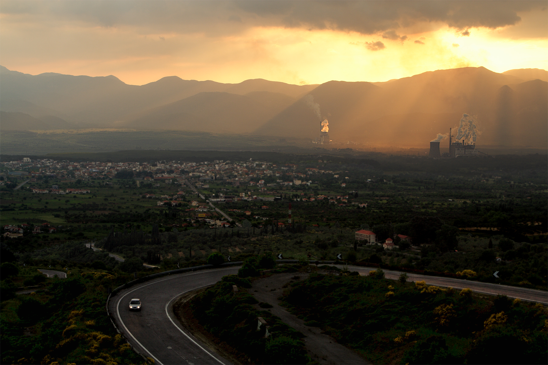
The Megalopoli Power Plant is a power plant in Arcadia in the central Peloponnese that produces electricity for southern Greece and the islands. It is located 5 km northwest of Megalopoli via the GR-76 (Krestena - Andritsaina - Megalopoli), its entrance is 1 km to the east. It produces electricity from coal and lignite mined south in the Megalopoli Mine as well as mines in Thoknia and Kyparissia. The plant employs up to 500 to 1,000 people, most of them are from Megalopoli.

Construction began in the mid-1960s just after the town was struck by an earthquake in 1965 (see the Arcadia earthquake). It took three to four years to complete. By 1971, electricity production began and mining also started. As all of its coal and lignite are being used up, the plant may close in a few years, potentially laying off hundreds of workers and causing a significant part of its economy to drop.

The power plant had been featured in an ERT documentary which broadcast on April 2007.

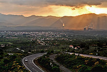
Megalopoli Power Plant (background).

Location

The plant is surrounded by Megalopoli's nearby forest to the southwest, the Alpheus River to the west and another to the north. The building is in the middle part, its towers are to the southwest and its reactors to the east. The plant can be seen around the valley, the Lykaio mountains to the north, its mountains to the north, the east and the west.

Pollution

Pollution has been a problem in the area as sulphur and carbon dioxide (CO2) have been emptied as low as 200 m during windy and cloudy days and as high as 1 km during clear days, visible from as far as 20 km as well as northwestern Laconia. The main concern is dumping used-up coal into the Alfeios which ruins its water supply and nature as well as the ancient city of Megalopoli which saw marble and stone begin to rust. Also, as with all fossil fuel based plants, the Megalopoli Power Plant produces large amounts of greenhouse gases that contribute to climate change.


Wikimedia Foundation. 2010.

Игры ⚽ Нужно решить контрольную?

Look at other dictionaries:

  • Megalopoli Mine — The Megalopoli Mine is a large lignite and coal mine owned by the Public Power Corporation of Greece that began in the early 1970s after the completion of the Megalopoli Power Plant which met demands for hydro in Greece. It mined approximately 40 …   Wikipedia

  • List of power outages — This is a list of notable wide scale power outages.1965* The Northeast Blackout of 1965 in the USA on November 9, 1965.1974* A freak early season blizzard on October 13, 1974 caused a major power outage that affected more than a million customers …   Wikipedia

  • Public Power Corporation — of Greece Unternehmensform Öffentliches Unternehmen ISIN GRS434003000 Unternehmens …   Deutsch Wikipedia

  • Choremis — Χωρέμης Location …   Wikipedia

  • Arcadia — Infobox Pref GR name = Arcadia name local = Νομός Αρκαδίας periph = Peloponnese capital = Tripoli population = 100,611 population as of = 2005 pop rank = 38th pop dens = 22.8 popdens rank = 52nd area = 4,419 area rank = 5th postal code = 22x xx… …   Wikipedia

  • Plaka, Arcadia — Plaka (Greek: Πλάκα) is a Greek settlement located around 5 km west northwest of Megalopoli, 10 km northwest from the nearest interchange with the GR 7/E65 (Kalamata Megalopoli Tripoli) and the old road and less than 16 km southeast of Karytaina …   Wikipedia

  • Thoknia — (Greek: Θωκνία), Latin and ancient form: Thocnia is a Greek settlement located around 9 km northwest of Megalopoli, 13 km south from the nearest interchange with the GR 7/E65 (Kalamata Megalopoli Tripoli) about 41 km west of Tripoli, about 63 km… …   Wikipedia

  • Choremi — (Greek: Χωρέμη) is a Greek settlement located around 10 km souhtwest (old: 5 km) from Megalopoli as about 4 km northwest from the nearest interchange with the GR 7/E65 (Kalamata Megalopoli Tripoli) or the old road. Choremi is also in the… …   Wikipedia

  • Greek National Road 76 — (Pyrgos Andritsaina Megalopoli) is a west to east highway linking 2 km W of Krestena with GR 9/E55, Andritsaina and SE of Megalopoli (until 2003, in Megalopoli). The highway west to Andritsaina is unofficially designated as GR 76 The west to …   Wikipedia

  • Soulos — (Greek: Σούλος) is a Greek settlement located around 8 km north northwest of Megalopoli, 15 km northwest from the nearest interchange with the GR 7/E65 (Kalamata Megalopoli Tripoli) and the old road and less than 13 km southeast of Karytaina.… …   Wikipedia

Share the article and excerpts

Direct link
Do a right-click on the link above
and select “Copy Link”