- Manitoba Highway 12
-
Highway 12
MOM's Way Route information Length: 256 km (159 mi) Major junctions South end:  MN 313 at US Border near Middlebro
 PTH 89 near Piney
 PTH 52 in Steinbach
 PTH 1 near Ste Anne
 PTH 15 in Anola
 PTH 44 near Tyndall
PTH 44 near Beausejour
 PTH 59 near Beaconia
North end: Grand Beach Highway system ←  PTH 11
PTH 13  →
→Provincial Trunk Highway 12 (PTH 12) is a provincial highway in the Canadian province of Manitoba. It runs from the U.S. border (where it meets with Minnesota State Highway 313) to a dead end in Grand Beach. PTH 12 forms the Manitoba section of MOM's Way, a route from Thunder Bay to Winnipeg.[1]
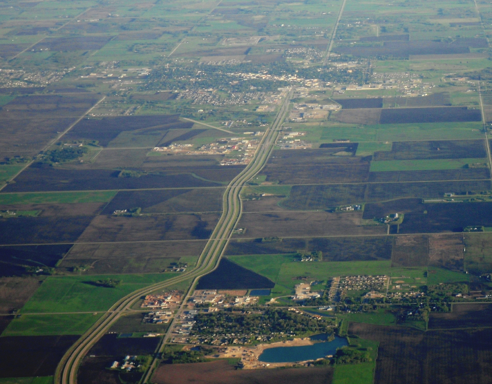
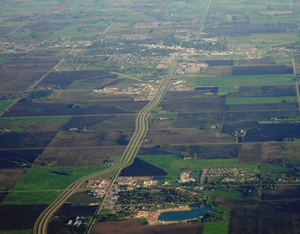 Highway 12 running south from Blumenort (lower) to Steinbach (upper) as a four lane road
Travel Route
This is the travel route for Provincial Trunk Highway 12 (PTH 12) from south to north.
km Municipality Location Interescting highway Notes 0 Piney R.M. US-Canada Border PTH 12 begins
highway travels west for the first 48 kilometres6 Middlebro 21 PR 308 north – Sprague, Moose Lake, East Braintree 31 PR 310 south – Roseau 48 PTH 89 south – Piney, Roseau, Red Lake, Bemidji
PR 201 west – Sundown, Vita, Stuartburn
PR 203 north – Badger, WoodridgePTH 12 turns northwest 62 PR 210 north – Woodridge, La Broquerie 84 Stuartburn R.M. PR 203 east – Woodridge, Badger
PR 404 north – SandilandsPTH 12 turns west 94 La Broquerie R.M. Zhoda PR 302 – Vita, La Broquerie, Richer, Beausejour PR 302 to Vita formerly PR 208 south 102 PR 403 west – St. Malo 113 Hanover R.M. PR 205 west – Grunthal, St. Pierre-Jolys PTH 12 turns north 3 km before junction 121 PR 303 east 128 Steinbach PTH 52 – Mitchell, La Broquerie133 PR 311 east – Giroux begin PR 311 west concurrence 137 Blumenort PR 311 west – Niverville end PR 311 west concurrence 144 Ste. Anne R.M. PR 210 west – Landmark, Île-des-Chênes begin PR 210 east concurrence 145 Ste. Anne PR 207 – Lorette, Richer
PR 210 east – La Broquerie, Woodridgeend PR 210 east concurrence 147 PTH 1 (TCH) – Winnipeg, Falcon Lake, Kenora152 Taché R.M. PR 501 – Ste. Geneniéve, Ross 166 Springfield R.M. Anola PTH 15 – Winnipeg, Dugald, Elma176 Brokenhead R.M. PR 213 west – Birds Hill 185 PR 215 east – Beausejour 187 PTH 44 west – Tyndall, Garson, LockportPTH 12 turns east
begin PTH 44 east concurrence197 Beausejour PTH 44 east – Whitemouth, West Hawk LakePTH 12 turns north
end PTH 44 east concurrence205 PR 435 – East Selkirk, Milner Ridge 218 PR 317 – Libau, Lac du Bonnet 232 St. Clements R.M. PR 304 – Powerview-Pine Falls, Bissett PTH 12 turns northwest 237 Alexander R.M. PTH 59 south – East Selkirk, Birds Hill, WinnipegPTH 12 turns north
begin PTH 59 north concurrence239 PR 304 east – Powerview-Pine Falls, Bissett
PR 500 north – Beaconia247 PTH 59 north – Victoria BeachPTH 12 turns northwest
end PTH 59 north concurrence251 PR 500 south – Beaconia 254 Grand Marais 256 Grand Beach PTH 12 ends See also
References
Highways in Manitoba Primary Secondary Winnipeg City Routes Categories:- Manitoba provincial highways
- Expressways in Manitoba
- Manitoba road stubs

Wikimedia Foundation. 2010.