- Madison County, Kentucky
-
Madison County, Kentucky 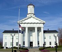 Madison County courthouse in Richmond, Kentucky
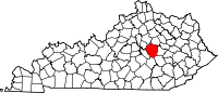
Location in the state of Kentucky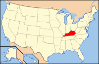
Kentucky's location in the U.S.Founded 1786 Named for James Madison (1751–1836), Founding Father, would later become 4th President of the United States (1809–1817). Seat Richmond Area
- Total
- Land
- Water
443.11 sq mi (1,148 km²)
440.68 sq mi (1,141 km²)
2.42 sq mi (6 km²), 0.55%Population
- (2008 (est.))
- Density
82,292
161/sq mi (62/km²)Time zone Eastern: UTC-5/-4 Website www.madisoncountyky.us Madison County is a county located in the U.S. state of Kentucky. As of 2008, the population was 82,192. Its county seat is Richmond.[1] The county is named for Virginia statesman James Madison, who later became the fourth President of the United States. This is also where famous pioneer Daniel Boone lived and built Fort Boonesborough, now a state historic site. Madison County is part of the Richmond-Berea micropolitan area.
It is considered a moist county, meaning that the county prohibits the sale of alcoholic beverages (a dry county), but contains a city where retail alcohol sales are allowed, specifically Richmond (although two of the city's 19 precincts are dry.[2]). Alcohol can also be sold by the drink by the Arlington and Bull Run golf clubs. In addition, the Acres of Land Winery is authorized to make and sell wine, and is also allowed to sell beer and wine by the drink at its on-site restaurant.[3]
Madison County is home to Eastern Kentucky University and Bybee Pottery,(closed February 2011) one of the oldest pottery operations in the United States.[4]
Contents
Geography
According to the 2000 census, the county has a total area of 443.11 square miles (1,147.6 km2), of which 440.68 square miles (1,141.4 km2) (or 99.45%) is land and 2.42 square miles (6.3 km2) (or 0.55%) is water.[5]
Adjacent counties
- Fayette County (north)
- Clark County (northeast)
- Estill County (east)
- Jackson County (southeast)
- Rockcastle County (south)
- Garrard County (southwest)
- Jessamine County (northwest)
Demographics
Historical populations Census Pop. %± 1790 5,772 — 1800 10,490 81.7% 1810 15,540 48.1% 1820 15,954 2.7% 1830 18,751 17.5% 1840 16,355 −12.8% 1850 15,727 −3.8% 1860 17,207 9.4% 1870 19,543 13.6% 1880 22,052 12.8% 1890 24,348 10.4% 1900 25,607 5.2% 1910 26,951 5.2% 1920 26,284 −2.5% 1930 27,621 5.1% 1940 28,541 3.3% 1950 31,179 9.2% 1960 33,482 7.4% 1970 42,730 27.6% 1980 53,352 24.9% 1990 57,508 7.8% 2000 70,872 23.2% 2010 82,916 17.0% http://ksdc.louisville.edu/ As of the census[6] of 2000, there were 70,872 people, 27,152 households, and 18,218 families residing in the county. The population density was 161 per square mile (62 /km2). There were 29,595 housing units at an average density of 67 per square mile (26 /km2). The racial makeup of the county was 93.01% White, 4.44% Black or African American, 0.28% Native American, 0.72% Asian, 0.02% Pacific Islander, 0.34% from other races, and 1.19% from two or more races. 0.97% of the population were Hispanics or Latinos of any race.
There were 27,152 households out of which 31.50% had children under the age of 18 living with them, 53.10% were married couples living together, 10.70% had a female householder with no husband present, and 32.90% were non-families. 25.20% of all households were made up of individuals and 7.60% had someone living alone who was 65 years of age or older. The average household size was 2.42 and the average family size was 2.90.
By age, 21.90% were under 18, 18.80% from 18 to 24, 29.40% from 25 to 44, 20.10% from 45 to 64, and 9.80% 65 or older. The median age was 31 years. Both the relatively large 18-to-24 population and the relatively low median age can be explained by the presence of Eastern Kentucky University, and to a considerably lesser extent Berea College. For every 100 females there were 93.30 males. For every 100 females age 18 and over, there were 90.20 males.
The median income for a household in the county was $32,861, and the median income for a family was $41,383. Males had a median income of $31,974 versus $22,487 for females. The per capita income for the county was $16,790. About 12.00% of families and 16.80% of the population were below the poverty line, including 17.80% of those under age 18 and 17.10% of those age 65 or over.
Cities and towns
See also
- Lonnie Napier (1940- ) - one of the current representatives for House District 36 in the Kentucky House of Representatives.
- National Register of Historic Places listings in Madison County, Kentucky
References
- ^ "Find a County". National Association of Counties. http://www.naco.org/Counties/Pages/FindACounty.aspx. Retrieved 2011-06-07.
- ^ Lanier, Yvette (2007-08-01). "Berea votes down alcohol sales again". Lexington Herald-Leader. http://kentucky.com/454/story/138641.html. Retrieved 2007-08-01.[dead link]
- ^ "Wet & Dry Counties in Kentucky" (PDF). Kentucky Office of Alcoholic Beverage Control. Archived from the original on March 15, 2007. http://web.archive.org/web/20070315092139/http://www.abc.ky.gov/NR/rdonlyres/88403470-8A7E-410C-9816-8B520F7649C8/0/WetDryList.pdf. Retrieved March 21, 2007.
- ^ Foust, Michele. "200-year-old Kentucky pottery business a sight to see ", Atlanta Journal-Constitution, 2007-02-25. Retrieved on February 23, 2009.
- ^ "Census 2000 U.S. Gazetteer Files: Counties". United States Census. http://www.census.gov/tiger/tms/gazetteer/county2k.txt. Retrieved 2011-02-13.
- ^ "American FactFinder". United States Census Bureau. http://factfinder.census.gov. Retrieved 2008-01-31.
External links
- Madison County government's website
- Madison County school district's website
- The Kentucky Highlands Project
- List of Madison County historic places on Placeography
Municipalities and communities of Madison County, Kentucky Cities Unincorporated
communitiesBaldwin | Bighill | Boonesborough | Bybee | Kirksville | Newby | Robinsville | Round Hill | Union City | Waco | Valley View
Categories:- Kentucky counties
- Madison County, Kentucky
- Richmond-Berea micropolitan area


Wikimedia Foundation. 2010.