- Kingaroy, Queensland
Infobox Australian Place | type = town
name = Kingaroy
state = qld
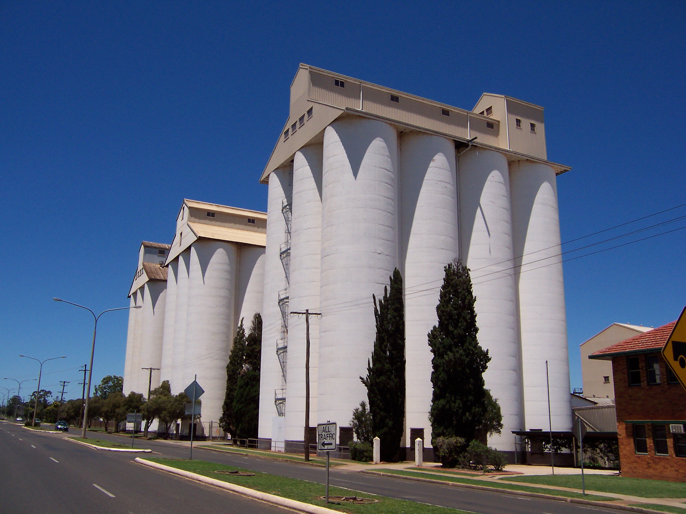
caption = The peanut silos in Haly Street are the town's tallest structures and most visible landmark.
lga =South Burnett Regional Council
postcode = 4610
est =
pop = 7,620
pop_footnotes=
elevation= 441.9
maxtemp = 24.7
mintemp = 11.3
rainfall = 779.9
stategov = Nanango
fedgov =Division of Maranoa
dist1 = 227
location1=Brisbane
dist2 = 152
location2= Toowoomba
dist3 = 144
location3= GympieKingaroy is an agricultural town in
Queensland ,Australia , approximately 209 kilometres or about 2.5 hours drive northwest of the state capitalBrisbane . The town is situated on the junction of the D'Aguilar and theBunya Highway s. At the 2006 census, Kingaroy had a population of 7,620 Census 2006 AUS|id=UCL332600
name=Kingaroy (Urban Centre/Locality)|accessdate=2007-11-12|quick=on] , a significant increase from the 2001 census figure of 7,147.Census 2006 AUS|id=UCL332600 |name=Kingaroy (Urban Centre/Locality)|accessdate=2007-11-12|quick=on]It is known as the "
Peanut Capital of Australia" because Australia's largest peanut processing plant is located in the town and peanut silos dominate the skyline. [ [http://tourism.southburnett.com.au/townkingaroy.htm "Kingaroy: The Peanut Capital", "South Burnett Tourism"] ] The name Kingaroy is usually claimed to be derived from the Wakka Wakka Aboriginal word for 'Red Ant '. The local Kingaroy Rugby League football team is known as "the Red Ants" and a Red Ant features on the old Kingaroy Shire coat of arms. However a Wakka Wakka Word List provides the following explanation: "Derived from 'king', a small black ant, and 'dhu'roi', meaning hungry. The name was suggested by a local Aboriginal helper of the surveyor Mr Hector Munro who surveyed the original grazing holding of this name on account of these ants being a pest at the survey camp". [Wakka Wakka Jinda Aboriginal Word List compiled by Mavis Hawkins]Kingaroy is also famous for being the home town of former
Premier of Queensland , the lateSir Joh Bjelke-Petersen . [ [http://www.smh.com.au/news/Queensland/Kingaroy/2005/02/17/1108500203487.html "Kingaroy", "Sydney Morning Herald"] 29 January, 2008.]History
Rural settlement of the area dates back to 1843 when one of the first selections was made at Burrandowan (west of Kingaroy) by squatter and explorer Henry Stuart Russell. Even through Russell was reputedly the first European to realise the potential of the South Burnett, it was Simon Scott of Taromeo (now Blackbutt) and the Haly brothers of Taabinga who brought the first flocks of sheep to the area in the late 1850s.
In 1878 the district where Kingaroy now stands was settled by the Markwell brothers. When the first resumptions were made from the enormous Taabinga holding, the brothers selected two adjoining areas and in 1883 these leases were converted to freehold and became known as the 'Kingaroy Paddock'. The corner of this paddock was located on what is now known as Haly Street, named after the brothers who settled at Taabinga Station about 12km south-west of present-day Kingaroy.
A small, prosperous village grew up around Taabinga in the 1890s but the arrival of the railway in 1904 led to a land explosion around Kingaroy and the development of Kingaroy as it now exists. Taabinga quickly declined into a
ghost town by the end ofWorld War I and today the original Taabinga Homestead and a few outbuildings are all that remain of it. The area oppositeKingaroy Airport is today known as "Taabinga Village" but is really only a suburb of Kingaroy. Kingaroy celebrated its Centenary in 2004.Kingaroy is also noted for being the first region in
Australia to be placed on Level 7 Water Restrictions, which occurred on October 1st, 2007.Attractions and services
Kingaroy itself is the largest town in the
South Burnett and the region's commercial centre, offering all the services, shopping facilities and many of the industries generally expected in much larger centres. The town has its own hotels, motels, caravan parks, bed and breakfasts and cabins; and a range of restaurants, fast food outlets and petrol stations (including 24-hour petrol stations). Unlike many towns of its size, Kingaroy has its own indoor shopping centre that includes Woolworths,Big W and several specialty retailers. Kingaroy also has a commercial aerodrome a few kilometres from the centre of town and is regularly served by major bus lines.Kingaroy has the most cosmopolitan feel of any South Burnett township but it's still a relaxed, friendly and informal country town at heart. It has the typical low-
humidity climate of all South Burnett townships and is surrounded by extensive (and very picturesque) farmlands interspersed with low rolling hills. The Booie Range, home to several wineries and cellar doors, lies immediately north-east of the town and theBunya Mountains about 55km to the south-west. The township is situated in the middle of some spectacular scenery, and is popular for bushwalking.The Central Business District of the township is dominated by the Peanut Company of Australia's peanut silos (a local landmark). The Information, Art and Heritage Precinct is located directly opposite the peanut silos. The complex includes the Kingaroy Shire Art Gallery, Visitor Information Centre, Heritage Museum and an interpretative arena which highlights local industries. The Heritage Precinct also includes a number of historic buildings ranging from Carroll's Cottage (the first building constructed in Kingaroy) through to the Carrollee Hotel and the Shire's earliest Council Chambers (built in 1918).
Industry and agriculture
Traditionally, Kingaroy has always been the centre of Australia's peanut and navy bean industries but since the early 1990s it has also developed into one of the twin hubs of the South Burnett's rapidly-expanding wine industry (the other hub is at Murgon, Redgate and Moffatdale, 55km to the north). Several wineries are located either in or very close to the town, along with the Booie Range Distillery which opened in 2001 - only the third distillery in Queensland.
Drought s and uncertainty surrounding the region's annual peanut crop led some farmers to diversify and grow grapes. Rich volcanic soil, hot dry summers and cold winters proved to be ideal conditions for wine growing. Quite a number ofvineyard s were established in the region, and the success of their wine enables the South Burnett region, which includes Kingaroy, to promote the area as a tourist destination. The success of this enterprise has been largely attributed to the scenery of the location, and has benefited the local economy.ports and culture
Kingaroy has a vibrant sporting, cultural and social life and is home to an art gallery and several local craft outlets as well as a range of well-maintained and attractive parklands. The town is host of many fine sportsman like NRL newcomer Chris Sandow, and Wallabies centre/ fly half Berrick Barnes, as well as Australian test and one day opener Matthew hayden. The town has two lookouts (at nearby Mt Wooroolin and Apex Park in Fisher Street) which provide striking panoramic views across the area. Kingaroy also has its own
golf club,cricket club, andbowls club. Live entertainment is held regularly at theReturned Services League club as well as several central hotels and in Kingaroy Town Hall. A half-dozen wineries are located either in town of very close to it. It is also has a notable speedway track.Major annual events include the Wine and Food In The Park Festival (held each March); the Kingaroy Show (held each May); the Burrandowan Picnic Races (held at Burrandowan on the outskirts of the Shire, also each May); the Kingaroy Peanut Festival (held each August); the two-day Taabinga Spring Music Festival (each October); and the Christmas Carnival (each December).
Notable Residents
There are many well-known people who can claim Kingaroy as their home town.
*Sir Joh Bjelke-Petersen formerPremier of Queensland and his wife former SenatorFlo Bjelke-Petersen
*Howard Government Cabinet MinistersWarren Truss and Ian Macfarlane.
*Australiancricket erMatthew Hayden
*Australian Rugby Union playerBerrick Barnes
*Australiancricket erCarl Rackemann
*Australian Rugby League playerDave Brown
* Current National Rugby League player Chris Sandow
* Former Australian and current NRL star Willie Tonga, as well as his younger brother Esikeli Tonga (Titan's under 20's)
* CurrentNational Rugby League PlayerMatt Ballin (Although he was born in Nanango, he was raised in Kingaroy).External links
* [http://www.kingaroy.qld.gov.au/ Kingaroy Shire Council] - Official council site
* [http://www.peanutfest.southburnett.com.au/ Kingaroy Peanut Festival]
* [http://www.winefood.southburnett.com.au/ Kingaroy Wine & Food in the Park Festival]
* [http://www.kcci.southburnett.biz/ KCCI] - Kingaroy Chamber of Commerce and Industry site
* [http://www.sbcare.org.au/ SBcare] - HACC and NRCP Service ProviderReferences
Wikimedia Foundation. 2010.