- Saskatchewan Highway 13
Infobox road
marker_
User:Pomte/Template:SK road shield|provincial|13
province=SK
type=Hwy
route=13
alternate_name=Red Coat Trail 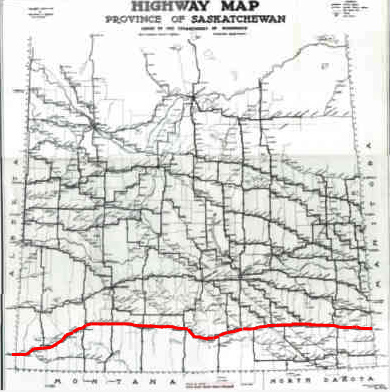
length_km=676
length_round=1
length_ref=cite map
publisher=Microsoft Corp.
title= Microsoft Streets and Tips
url=
edition=2004
section=Route Planner
accessdate=2008-02-17]
established=
maint=Ministry of Highways and Infrastructure (Saskatchewan)
direction_a=West
starting_terminus=Alberta Highway 501 Alberta
junction=
direction_b=East
ending_terminus=Antler; Highway 2Manitoba
rural_municipalities=
cities=Weyburn
previous_type=Hwy
previous_route=12
next_type=Hwy
next_route=14Highway 13 is a highway in the Canadian province of Saskatchewan. It runs from the
Alberta border (continuing westward asAlberta Highway 501 ) until it transitions into Highway 2 at theManitoba border near Antler. Highway 13 is about 676 km (420 mi.) long.Communities along the route
Highway 13 passes through Shaunavon, Assiniboia, Weyburn, Redvers and Carlyle. It is also referred to as the
Red Coat Trail , as much of its length follows the route of the original historic path. [cite web
last =
first =
authorlink =
coauthors =
title = REDA - Recreation
work =
publisher = Red Coat Regional Economic Development Authority Inc.
date = 2007
url = http://www.redcoatreda.com/html/lifestyle/recreation.html
format =
doi =
accessdate = 2007-09-25 ]Weyburn, the opportunity city,has also been dubbed the "Soo Line City" due its connection with
Chicago on the Soo Line of the Canadian Pacific Railway CPR.cite web
last = Weyburn Writer's Association
first =
authorlink =
coauthors =
title =Hey, seeds!
work = Our Roots Nos Racines
publisher = University of Calgary, Université Laval
date =2006
url = http://www.nosracines.ca/e/page.aspx?id=545038
format =
doi =
accessdate = 2008-04-15] The city of 9,433 cite web
last =
first =
authorlink =
coauthors =
title =2006 Community Profiles - Census Subdivision
work =Statistics Canada
publisher = Government of Canada
date = 04/02/2008
url = http://www12.statcan.ca/english/census06/data/profiles/community/Details/Page.cfm?Lang=E&Geo1=CSD&Code1=4702047&Geo2=PR&Code2=47&Data=Count&SearchText=Weyburn&SearchType=Begins&SearchPR=01&B1=All&Custom=
format =
doi =
accessdate = 2008-04-15 people is situated on Sk Hwy 35, Sk Hwy 39, and Sk Hwy 13.cite web
last =
first =
authorlink =
coauthors =
title =Canadian Rural Partnership - Rural Development - Public - Private Partnerships in Rural and Northern Canada Study - Appendix C - List of Projects
work = Government of Canada
publisher =
date =2005-09-26
url = http://ndpcaucus.sk.ca/topics/read.php3/423.html
format =
doi =
accessdate = 2008-04-15] The small towns of Exon and Converge have been absorbed into the city of Weyburn today. [cite web
last = Adamson
first = J
authorlink =
coauthors =
title =Saskatchewan, Canada, Rand McNally 1924 Indexed Pocket Map Tourists' and Shippers' Guide<
work =Online Historical Map Digitization Project
publisher = Ancestry / Rootsweb
date = Wednesday, 05-Nov-2003
url = http://www.cfib.ca/legis/sask/pdf/sk0260.pdf
format =
doi =
accessdate = 2008-04-15 The Pasqua branch or the Souris, Arcola, Weyburn, Regina CPR branch, Portal Section CPR on the Soo Line, Moose Jaw, Weyburn, Shaunavon, Lethbridge section CPR, The Brandon, Marfield, Carlyle, Lampman, Radville, Willow Bunch sectionCNR, and the Regina, Weyburn, Radville, Estevan, Northgate section CNR have all run through Weyburn. [cite web
last = Adamson
first = J
authorlink =
coauthors =
title =Canadian Maps: May 1948 Waghorn's Guide. Post Offices in Man. Sask. Alta. and West Ontario.
work =Online Historical Map Digitization Project
publisher = Rootsweb
date = Wednesday, 05-Nov-2003
url = http://www.rootsweb.ancestry.com/~canmaps/1948Waghorn/May1948-14-15.html
format =
doi =
accessdate = 2008-04-15] Weyburn is located astride the Williston geological Basin which contains oil deposits, and several wells operate in the vicinity. Weyburn features roadside attractions of a large Lighthouse Water Tower, Wheat sheaves and Prairie Lily. [cite web
last = Donnan
first =Richard
authorlink =
coauthors =
title = Lighthouse Water Tower Weyburn, Saskatchewan
work =
publisher = LARGE CANADIAN ROADSIDE ATTRACTIONS
date = 1999 - 2006
url = http://www.roadsideattractions.ca/weyburn.htm
format =
doi =
accessdate = 2008-02-15] Weyburn is situated near the upper delta of the 470 mile long Souris River. The Souris River continues southeast through North Dakota eventually meeting the Assiniboine River in Manitoba. cite web
last = Weyburn Writer's Association
first =
authorlink =
coauthors =
title =Hey, seeds!
work = Our Roots Nos Racines
publisher = University of Calgary, Université Laval
date =2006
url = http://www.nosracines.ca/e/page.aspx?id=545038
format =
doi =
accessdate = 2008-04-15] In the 1800s this area was known as an extension of the "Greater Yellow Grass Marsh". Quotation|Extensive flood control programs have created reservoirs, parks and waterfowl centres along the Souris River.| cite web
last =
first =
authorlink =
coauthors =
title =Canadian Rural Partnership - Rural Development - Public - Private Partnerships in Rural and Northern Canada Study - Appendix C - List of Projects
work = Government of Canada
publisher =
date =2005-09-26
url = http://ndpcaucus.sk.ca/topics/read.php3/423.html
format =
doi =
accessdate = 2008-04-15] Between 1988 to 1995, the Rafferty-Alameda Project was constructed to alleviate spring flooding problems created by the Souris River.cite web
last =
first =
authorlink =
coauthors =
title =Water Control - Saskatchewan Dams and Reservoirs
work = Saskatchewan Watershed Authority
publisher =
date =
url =http://www.swa.ca/WaterManagement/DamsAndReservoirs.asp?type=RaffertyAlameda#
format =
doi =
accessdate = 2008-04-15]Red Coat Trail
The Royal Canadian Mounted Police Academy and
RCMP Heritage Centre are both located in the capital city of Regina. The The Royal Canadian Mounted Police Academy is a training facility for "Red Coats" or the "Royal Canadian Mounted Police" officers, while theRCMP Heritage Centre is a museum relates history and memorabilia of the RCMP. Fort Walsh was home to the North-West Mounted Police in the 1800s. Located in south western Saskatchewan, it oversaw activities in the Big Muddy Badlands north of the CanadianUnited States border.Sitting Bull ,James Walsh ,Big Bear ,James Macleod ,Sam Steele , Dutch Henry, Jones-Nelson gang,Sam Kelly , ChiefSitting Bull ,Crazy Horse ,John A. Macdonald andGeorge Armstrong Custer are some names of historic legend in this area. [cite web
last =
first =
authorlink =
coauthors =
title = KOA: Red Coat Trail through "The Land of the Living Skies."
work =Kampgrounds of America, Inc
publisher =
date = 2008
url = http://www.koa.com/vacationideas/redcoat/saskatchewan.htm
format =
doi =
accessdate =2008-01-13 ]References
Wikimedia Foundation. 2010.