- Washoe County, Nevada
Infobox U.S. County
county = Washoe County
state = Nevada

map size = 150
founded = 1861
seat = Reno | area_total_sq_mi =6551
area_land_sq_mi =6342
area_water_sq_mi =209
area percentage = 3.19%
census yr = 2007
pop = 418061
density_km2 =21
web = www.washoecounty.us
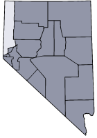
|Washoe County is a
county located in theU.S. state ofNevada . The population was 339,486 at the 2000 census; 2006 Census Bureau estimates listed a population of 396,428. [cite web | url = http://www.census.gov/popest/cities/files/SUB-EST2006_32.csv | title = Subcounty population estimates: Nevada 2000-2006| format = CSV | publisher =United States Census Bureau , Population Division | date =2007-06-28 | accessdate = 2008-05-28] . Itscounty seat is Reno.GR|6Washoe County is part of the Reno–Sparks Metropolitan Statistical Area.
History
Washoe County was created in 1861 as one of the original nine counties of Nevada. It is named after the Washoe people who originally inhabited the area. It was consolidated with Roop County in 1864. Washoe City was the first county seat in 1861 and was replaced by Reno in 1871.
Geography
According to the U.S. Census Bureau, the county has a total area of 6,551
square mile s (16,968km² ), of which, 6,342 square miles (16,426 km²) of it is land and 209 square miles (541 km²) of it is water. The total area is 3.19%There are two incorporated cities within the county: Reno, and Sparks.
Major highways
*
*
*
*Adjacent counties
*
Humboldt County, Nevada - east
*Pershing County, Nevada - east
*Churchill County, Nevada - east
*Lyon County, Nevada - southeast
*Storey County, Nevada - south
*Carson City, Nevada - south
*Placer County, California - southwest
*Nevada County, California - west
*Sierra County, California - west
*Lassen County, California - west
*Modoc County, California - west
*Lake County, Oregon - north
*Harney County, Oregon - northeastDemographics
As of the
census GR|2 of 2000, there were 339,486 people, 132,084 households, and 83,741 families residing in the county. Thepopulation density was 54 people per square mile (21/km²). There were 143,908 housing units at an average density of 23 per square mile (9/km²). The racial makeup of the county was 80.41% White, 2.09% Black or African American, 1.82% Native American, 4.28% Asian, 0.46% Pacific Islander, 7.67% from other races, and 3.28% from two or more races. 16.58% of the population were Hispanic or Latino of any race.There were 132,084 households out of which 31.10% had children under the age of 18 living with them, 47.90% were married couples living together, 10.30% had a female householder with no husband present, and 36.60% were non-families. 27.00% of all households were made up of individuals and 7.70% had someone living alone who was 65 years of age or older. The average household size was 2.53 and the average family size was 3.09.
In the county the population was spread out with 24.90% under the age of 18, 9.80% from 18 to 24, 31.00% from 25 to 44, 23.80% from 45 to 64, and 10.50% who were 65 years of age or older. The median age was 36 years. For every 100 females there were 102.80 males. For every 100 females age 18 and over, there were 101.80 males.
The median income for a household in the county was $45,815, and the median income for a family was $54,283. Males had a median income of $36,226 versus $27,953 for females. The
per capita income for the county was $24,277. About 6.70% of families and 10.00% of the population were below thepoverty line , including 12.20% of those under age 18 and 6.20% of those age 65 or over.Communities
Cities
Census-designated places
*Cold Springs
*Gerlach-Empire
*Incline Village-Crystal Bay
*Lemmon Valley-Golden Valley
*Nixon
*Spanish Springs
*Sun Valley
*Sutcliffe
*Verdi-Mogul
*WadsworthOther communities
*New Washoe City
*Pleasant Valley
*Vyaee also
*
Reno 911! , aparody cop show set in Washoe CountyReferences
External links
* [http://www.washoecounty.us County website]
* [http://www.nevada-landmarks.com/washoe.htm Historical Markers of Washoe County]
Wikimedia Foundation. 2010.