- Gerringong, New South Wales
Infobox Australian Place | type = town
name = Gerringong
state = New South Wales
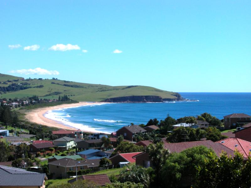
caption = A view of Werri Beach and part of the town
lga = Municipality of Kiama
postcode = 2534
est = 1854
pop = 4188
elevation=
maxtemp =
mintemp =
rainfall =
stategov = Kiama
fedgov = Gilmore
dist1 = 210
location1=Sydney
dist2 = 12
location2= KiamaGerringong is a town about 10 minutes south of Kiama in the Illawarra region of
New South Wales ,Australia in theMunicipality of Kiama . One theory says that the name derives from an Aboriginal word meaning "fearful place".cite web
title =Brief History
publisher =TravellerTV, Gerringong
date =2002-2007
url =http://www.gerringong-gerroa.com/history-centre.htm
accessdate = 2007-01-23 ] Supposedly great fear was caused to tribes there by the sight ofCaptain Cook 's ship in full sail. There are other theories as to the meaning of the name.History
The first European settlers were red cedar cutters, who were first recorded as having visited and logged in the area in 1814. As in much of coastal New South Wales, the cleared land was used for dairy farming and cedar-cutting died out, as the cedar trees disappeared. Dairy farming became the predominant primary industry, and remains so to this day. Gerringong had a small boat harbour used for the export of cedar and dairy produce.
In 1824, Governor Brisbane reserved 600 acres (2.4 km²) for the present Gerringong township. In 1827 Michael Hindmarsh and his family were granted 640 acres (2.6 km²) and became the first settler in the Gerringong area. In 1829 Gerringong was incorporated into the postal system. The "Alne Bank" homestead was built in 1851 for the Hindmarshes, who still live there today and occasionally open it for inspection.
In 1854, a town plan for Gerringong was approved and the Governor proclaimed it a village. In 1872 the business area,
Church of England church and some houses were destroyed by abush fire . In 1893 the South Coast railway line was extended to Gerringong, [cite web
url=http://www.nswrail.net/locations/show.php?name=NSW:Gerringong&line=NSW:south_coast:0
title=Gerringong Railway Station
publisher=www.nswrail.net
accessdate=2007-01-23 ] leading to the end of shipping from the town. Telephone services were extended to Gerringong in 1913 and electricity in 1928.In 1933 Sir
Charles Kingsford Smith undertook his historic flight from nearby Seven Mile Beach toNew Zealand . A memorial stone at Gerroa marks the event.In 1954 Gerringong Municipal District amalgamated with Kiama Municipal Council. Town water supply connected in 1971, signalling an end to tanks attached to each house. This is highly controversial now that NSW is in deep drought (2005) and water from the dam catchment areas is in scarce supply. Land along the coastal fringe tends to receive higher rainfall than the interior water catchment areas, which are often in rainshadow. 2002 Town sewerage system connected. [cite web
title =Gerringong's Historical Time Line
publisher =TravellerTV, Gerringong
date =2002-2007
url =http://www.gerringong-gerroa.com/time-line.htm
accessdate = 2007-01-23 ]Modern Gerringong
The population of Gerringong and the area is around 4,000 people and growing. Many are retirees from
Sydney andCanberra , others enjoy the seaside lifestyle but commute to work in Wollongong or Nowra and evenSydney . The main local industries are agriculture (including dairying and vineyards), tourism and retail trade.The town has a modern primary school, a town hall (built 1948), a large retirement village and a thriving tourist industry. Especially in the summer months, when visitors (mostly from
Sydney andCanberra ) flock to the pristine beaches, to enjoy swimming, surfing, fishing and relaxing in the restaurants and cafés plus hunting for treasures in the shops and boutiques. There are two vineyards producing award-winning wines, one with cellar-door sales.Gerringong railway station is served by a
CityRail diesel train, connecting with electric trains toSydney atKiama . Local bus companies connect Gerringong toKiama andNowra on a daily basis, and interstate buses connect it withSydney andMelbourne and all stops in between.The Gerringong and District Historical Society runs the Heritage Museum, containing lots of fascinating items, scale models of buildings, a photographic record of motor racing on Seven Mile Beach in the 1920s, and a display on the local dairying industry. The Society has a facility to do genealogy computer searches of a full database of Pioneer Family descendants, and also Birth, Death and Marriage records relating to the Gerringong area.Geography
The boundaries of the Gerringong District range from Mount Pleasant and Omega in the north, to Rose Valley, Willow Vale and Foxground in the west, and to Broughton Village, Toolijooa, Harley Hill, Gerroa and Seven Mile Beach in the south. In the centre of the area lies the town of Gerringong itself, and the nearby area of Werri Beach.
Gerringong is known as "Where the Mountains Meet the Sea" due to an advertising campaign. A spur of Saddleback Mountain reaches down to Mt Pleasant to the north of Gerringong township, ending the spectacular Illawarra escarpment, which starts north of Wollongong. The area is famous for its picturesque coastline, incorporating rugged sea cliffs, pristine golden beaches surrounded by rolling hills and countryside, which stays velvety green year-round.
The
Princes Highway bypasses Gerringong township on its western edge, with two exits, one at Fern St and another at Belinda Street, 2km further south. Gerringong and Werri Beach used to be two separate localities, but they have now grown together without any definitive boundary.Werri Lagoon, which (sometimes) empties to the sea at the northern end of Werri Beach, used to naturally exit near the Gerringong Surf Club at the south end... until human intervention occurred in the 1960s. Bridges Road used to be access to a bridge which provided access to Werri Beach. More often that not nowadays, the lagoon is isolated from the sea by a sandspit which has to be opened by mechanical means to allow it to drain after high rainfall or lengthy periods of closure, which results in stagnation and pollution. When extra high tides occur, the water still washes over Pacific Avenue at the south end, where the lagoon used to empty in the ocean. when it is opened by the council the locals surf and body board the standing wave that the outward rushing water produces.
Gerringong's Boatharbour, was extensively used for shipping timber and dairy produce in the 19th century. At one time a lengthy jetty existed, but it was destroyed in fierce storms in 1891. It was never rebuilt.
Gerringong's geology is basically basalt, laid down in the Permian era.
Climate
Gerringong has temperate maritime climate. Warm to hot summers and cool wet winters. Temperatures average out at around 25°C max & 18°C min in February to 16°C max & 8°C min in July. Sea temperatures vary from an average of 23.5°C in February to 17.7°C in August.
Politics
Gerringong is part of the
Municipality of Kiama , Mayor Sandra McCarthy is a resident of Gerringong. Local residents are represented by the Member of NSW Parliament for Kiama, currently Matt Brown. The area is represented by the Federal Member for Gilmore, currentlyJoanna Gash .External links
* [http://www.gerringong-gerroa.com/ Gerringong-Gerroa Community Web Site] - lots of information, history, maps, photo galleries, tide chart, news, bus and train timetables, movies plus an extensive business directory with accommodation, restaurants etc.
References
* [http://www.fallingrain.com/world/AS/2/Gerringong.html FallingRain Map - elevation = 1m]
Wikimedia Foundation. 2010.