Norton Subcourse

Norton Subcourse

Coordinates: 52°31′54″N 1°33′24″E / 52.53178°N 1.55655°E / 52.53178; 1.55655

Norton Subcourse
Norton Subcourse-g3.jpg
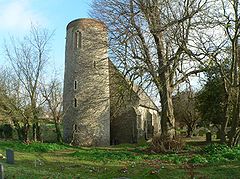
Norton Subcourse St Mary
Norton Subcourse is located in Norfolk
Norton Subcourse

 Norton Subcourse shown within Norfolk
Area  9.05 km2 (3.49 sq mi)
Population 303 
    - Density  33 /km2 (85 /sq mi)
OS grid reference TM413985
Parish Norton Subcourse
District South Norfolk
Shire county Norfolk
Region East
Country England
Sovereign state United Kingdom
Post town NORWICH
Postcode district NR14
Police Norfolk
Fire Norfolk
Ambulance East of England
EU Parliament East of England
List of places: UK • England • Norfolk

Norton Subcourse is a small village and parish in the county of Norfolk, England, about 9 miles south-west of Great Yarmouth. It covers an area of 9.05 km2 (3.49 sq mi) and had a population of 303 in 115 households as of the 2001 census.[1]

Its church, St Mary, is one of 124 existing round-tower churches in Norfolk.

Norton Subcourse is mentioned in the Domesday Book as one of the settlements in Clavering hundred.

Notes

External links


Wikimedia Foundation. 2010.

Игры ⚽ Поможем написать реферат

Look at other dictionaries:

  • List of civil parishes in Norfolk — This is a list of civil parishes in the county of Norfolk, England. It is broken down by the seven local authority districts that make up the county.BrecklandBreckland is entirely parished, and comprises the following parishes:*Ashill… …   Wikipedia

  • List of places in Norfolk — This is a list of cities, towns and villages in the ceremonial and shire county of Norfolk, England. See the list of places in England for places in other counties. Contents Top 0–9 A B C D E F G H I J K L M N O P Q R S T U V W X Y Z NOTOC A*Acle …   Wikipedia

  • Round-tower church — Round tower churches are a type of church found mainly in England, almost solely in East Anglia; of about 185 surviving examples in the country, 124 are in Norfolk, 38 in Suffolk, 6 in Essex, 3 in Sussex and 2 each in Cambridgeshire and Berkshire …   Wikipedia

  • Ditchingham — Coordinates: 52°28′00″N 1°26′37″E / 52.46676°N 1.44351°E / 52.46676; 1.44351 …   Wikipedia

  • South Norfolk — is a local government district in Norfolk, England. Its council is based in Long Stratton.HistoryThe district was formed on April 1, 1974, under the Local Government Act 1972, as a merger of Diss Urban District, Wymondham Urban District, Depwade… …   Wikipedia

  • Diss — Not to be confused with Dis. This article is about the English town called Diss. For music created for the purpose of verbally attacking others, see diss track. Coordinates: 52°22′52″N 1°06′28″E /  …   Wikipedia

  • Costessey — Coordinates: 52°39′37″N 1°12′58″E / 52.66023°N 1.21614°E / 52.66023; 1.21614 …   Wikipedia

  • Denton, Norfolk — Coordinates: 52°26′46″N 1°21′20″E / 52.446175°N 1.355438°E / 52.446175; 1.355438 …   Wikipedia

  • Cringleford — Coordinates: 52°36′20″N 1°14′36″E / 52.6056°N 1.24333°E / 52.6056; 1.24333 …   Wikipedia

  • Bawburgh — Coordinates: 52°38′00″N 1°11′00″E / 52.6333°N 1.1833°E / 52.6333; 1.1833 …   Wikipedia

Share the article and excerpts

Direct link
Do a right-click on the link above
and select “Copy Link”