- Dasmina Upazila
-
Dasmina
দশমিনা— Upazila — Location in Bangladesh
 Dasmina
Coordinates: 22°17′N 90°35.4′E / 22.283°N 90.59°ECoordinates: 22°17′N 90°35.4′E / 22.283°N 90.59°E Country  Bangladesh
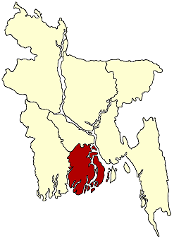
Division Barisal Division District Patuakhali District Area - Total 351.74 km2 (135.8 sq mi) Population (1991) - Total 106,539 - Density 303/km2 (784.8/sq mi) Time zone BST (UTC+6) Website Official Map of the Dasmina Upazila Dasmina (Bengali: দশমিনা ) is an Upazila of Patuakhali District in the Division of Barisal, Bangladesh.
Contents
Geography
Dasmina is located at 22°17′00″N 90°35′25″E / 22.2833°N 90.5903°E . It has 19,863 units of house hold and total area 351.74 km².
Demographics
As of the 1991 Bangladesh census, Dasmina has a population of 106,539. Males constitute 49.5% of the population, and females 50.5%. This Upazila's eighteen and older population is 52,137. Dasmina has an average literacy rate of 29.5% (7+ years), and a national average of 32.4%.
Administrative
Dasmina has 6 Unions/Wards, 51 Mauzas/Mahallas, and 55 villages. The names of the Unions are Dashmina, Alipura, Banshbaria, Rono Gopaldi, Bohorampur and Betagi Shankipur. The Upazila Headquarters is situated in Dashmina Sadar. It is situated on the Bank of the river Tetulia. It is a very old place. At present it holds One College, one Boys' High School, One Girls' School, One Alia Madrasa and a number of Government and Non Government Primary School.
See also
References
 Upazilas of the Barisal Division
Capital: Barisal Barguna District 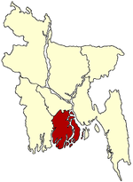
Barisal District Agailjhara · Babuganj · Bakerganj · Banaripara · Gaurnadi · Hizla · Barisal · Mehendiganj · Muladi · WazirpurBhola District Jhalokati District Patuakhali District Pirojpur District Categories:- Upazilas of Patuakhali District
- Barisal Division geography stubs

Wikimedia Foundation. 2010.