- Oregon Route 413
-
Oregon Route 413
Route information Maintained by ODOT Length: 11.45 mi (18.43 km) Existed: 2003 – present Major junctions South end: 
 OR 414 and OR 86 Spur in Halfway
North end: Cornucopia Trail in Cornucopia Highway system Oregon highways
Routes • Highways←  OR 410
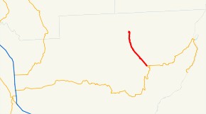
OR 414 →Oregon Route 413 (OR 413) is an Oregon state highway running from Cornucopia to Halfway. OR 413 is known as the Halfway-Cornucopia Highway No. 413 (see Oregon highways and routes). It is 11.45 miles (18.43 km) long and runs northwest to southeast, entirely within Baker County.
OR 413 was established in 2003 as part of Oregon's project to assign route numbers to highways that previously were not assigned, and, as of July 2010, was unsigned.
Contents
Route description
OR 413 begins at Elk Creek in Cornucopia and heads southeast through Carson and Jimtown to Halfway, where it ends at an intersection with OR 414 and OR 86 Spur. Its northernmost 6 miles (9.7 km) are unpaved and narrow.
History
The Halfway-Cornucopia Highway was established in 1935 with the division of the old Baker-Cornucopia Highway into the Baker-Halfway Highway No. 12 and the Halfway-Cornucopia Highway. OR 413 was assigned to the Halfway-Cornucopia Highway in 2003.
Major intersections
Milepost City Intersection 0.00 Cornucopia Begin Route 11.45 Halfway OR 414 and OR 86 Spur References
- Oregon Department of Transportation, Descriptions of US and Oregon Routes, http://www.oregon.gov/ODOT/HWY/TRAFFIC/TEOS_Publications/PDF/Descriptions_of_US_and_Oregon_Routes.pdf, page 31.
- Oregon Department of Transportation, Halfway-Cornucopia Highway No. 413, ftp://ftp.odot.state.or.us/tdb/trandata/maps/slchart_pdfs_1980_to_2002/Hwy413_1996.pdf
- Oregon Highways, Baker City-Copperfield Highway #12 (Archive), http://web.archive.org/web/20050206182806/www.ylekot.com/orehwys/hwy-12.html
Categories:- State routes in Oregon
- Transportation in Baker County, Oregon


Wikimedia Foundation. 2010.