- Mount Lindesay Highway
-
Mount Lindesay Highway
Beaudesert Road
Length 129 km (80 mi) Direction West-East From  Ipswich Road,
Moorooka, Brisbanevia Jimboomba, Beaudesert, Rathdowney To  Summerland Way, 15km east of Woodenbong, New South Wales NSW/Qld Border
Major junctions  Granard / Riawena Roads
 Learoyd Road
Compton Road
 Logan Motorway
 Browns Plains Road
 Stockleigh Road
 Beaudesert-Nerang Road
Beaudesert-Boonah Road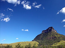 Mount Lindesay, Queensland, Australia
The Mount Lindesay Highway is a highway in Queensland which has been given the national route number 13. It runs from Brisbane, where it leaves Ipswich Road in the suburb of Moorooka (as Beaudesert Road to the Logan Motorway), to the New South Wales border where it becomes the Summerland Way heading south to Kyogle.
The highway used to extend to Tenterfield but that section of the road, which includes some unpaved portions, was decommissioned as a highway by the New South Wales Government.
It is quite a scenic road, particularly south of Beaudesert. It connects to the northern end of the Lions Road a scenic drive between Innesplain and the Summerland Way just south of Rosebery, passing Mount Chinghee National Park and Border Ranges National Park on the way.
It is named after Mount Lindesay, the residue of a solidified magma core, that is part of the Mount Warning volcanic area and is situated in the western extreme of Border Ranges National Park.
Between 2007 and 2009 4.5 km of the highway in Logan was upgraded.[1] The work included building service roads so that local traffic didn't have to travel on the highway, thereby reducing congestion.
Contents
List of towns on the Mount Lindesay Highway
- Logan City
- Jimboomba
- Beaudesert
- Rathdowney
See also
References
- ^ Kevin Gomez (7 December 2009). "Mount Lindesay Highway upgrade in Logan completed". Road Construct. Reed Business Information. http://www.roadconstruct.com.au/news/mount-lindesay-highway-upgrade-in-logan-completed. Retrieved 16 July 2010.
External links
- Mt Lindesay Highway, ozroads
 Road infrastructure in Queensland
Motorways 
National Highways Highways Balonne Highway • Barwon Highway • Brisbane Valley Highway • Burnett Highway • Bunya Highway • Capricorn Highway • Captain Cook Highway • Carnarvon Highway • Castlereagh Highway • Centenary Highway • D'Aguilar Highway • Dawson Highway • Donohue Highway • Flinders Highway • Gold Coast Highway • Gregory Highway • Isis Highway • Kennedy Highway • Leichhardt Highway • Mary Valley Highway • Mitchell Highway • Moonie Highway • Mount Lindesay Highway • Mulligan Highway • Outback Highway • Palmerston Highway • Peak Downs Highway • Wide Bay HighwayDevelopmental Roads /
Outback TracksBirdsville Track • Burke Developmental Road • Gregory Developmental Road • Gulf Developmental Road • Kennedy Developmental Road • Savannah WayProposals Categories:- Australia road stubs
- Australian highways


Wikimedia Foundation. 2010.