- Murray River (Western Australia)
-
Murray River 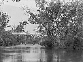
Pinjarra Bridge over the Murray River. ca 1900-1910Origin Mount Keats Mouth Peel-Harvey Estuary Basin countries Australia Length 134 kilometres (83 mi) Source elevation 187 metres (614 ft)[1] Mouth elevation sea level The Murray River is a river in the southwest of Western Australia which played a significant part in the expansion of Aboriginal settlement in the area south of Perth after the arrival of British settlers at the Swan River Colony in 1829.
The river is one of the few major rivers in close proximity to Perth which is devoid of dams for public water supply. It includes a catchment area including a large part of the wheatbelt and south-west of the state, draining from 450 mm/year average rainfall country in the east near Pingelly, westward through the high rainfall parts of the Darling Range around Dwellingup with an average rainfall of 1,300 mm/year.
The first of the two major tributaries, the Hotham River starts its journey near Narrogin. The other major tributary is the Williams River which starts between Williams and Narrogin. These two tributaries are the main rivers which drain the eastern wheat-belt.
The Murray River then flows through forested high rainfall parts of the Darling Range to emerge near Pinjarra.
Another tributary, the Dandalup River joins the Murray a short distance downstream of Pinjarra. This section is known as the lower Murray and is navigable in small boats. The river then flows across the sand plain between the Darling Scarp and the coast to empty into the Peel Estuary near Mandurah.
The canal development of North and South Yunderup is situated several kilometers upstream from the estuary.
Contents
History
The first European exploration of the area was in July 1829 when a group, led by Captain Currie of the HMS Challenger and accompanied by botanist James Drummond marched a short distance inland from present day Rockingham and after climbing a small hill at what is now Baldivis, sighted a river in the distance. This was later named the Serpentine River which is to the north of the Murray and for some time was confused with the Murray which was not encountered until later that year.
In November, Dr Alexander Collie and Lieutenant William Preston and crew from HMS Sulphur piloted two whaleboats out of Cockburn Sound and at midday on 17 November 1829 crossed the ocean bar at present day Mandurah. After camping overnight, they sailed south down the Peel-Harvey Estuary to the southern extreme near the delta of the Harvey River where they had an amicable encounter with some local aborigines.
Due to strong winds, they sailed north out of the estuary without exploring the western shore where the Murray River enters the estuary. The group then exited through the ocean bar and sailed south along the coast as far as the Collie and Preston Rivers and the Leschenault Inlet before returning to the Peel-Harvey estuary on the 28 November 1829. From there they explored the Murray River delta which at the time included five entrances into the estuary. The boats managed to navigate about two miles (3 km) up the river before returning to Fremantle after the 12 day trip.
This was the first actual encounter with the Murray River and was named by Governor James Stirling after the Secretary of State for the Colonial Office in London, Sir George Murray.
Within a few months, settlers from the Swan River had started to explore the river and choose blocks along its banks.
Thomas Peel
Thomas Peel had left Britain with a promise that if he arrived at Fremantle by the beginning of November 1829 with 400 settlers, he would be allocated a grant of 250,000 acres (1,000 km2) comprising much of the land on the south bank of the Swan River to Cockburn Sound. As he arrived six weeks late and with only 169 settlers, the offer was withdrawn by Governor Stirling as the land had been granted to established settlers. Peel was offered an alternative grant from Woodman Point to the north bank of the Murray River and from the ocean to the Darling Scarp.
Peel's remaining settlers arrived shortly after and settled initially at Clarence before moving to the site of present day Mandurah which he named Peeltown.
Despite many problems faced by the settlers, the area was gradually expanded and a settlement at Pinjarra had been established by late 1830. Pinjarra was approximately the upper limit of navigable water along the Murray River. It also had a natural ford for travellers at nearby Oakley Brook.
More land allocations along the southern bank of the river were made however settlement seemed to be limited to no further south that the Murray River grants, partly because of continuing and increasing conflicts with local aborigines. These conflicts culminated in the infamous Battle of Pinjarra in October 1834 where up to 40 Noongar people of the local Pindjarup tribal group were killed by white settlers. The battle had followed a raid in Perth by members of the Murray River tribe. The following year a formal truce was made between the Murray River and the Swan River Noongars and the white settlers.
Relative peace was established and expansion around the towns of Pinjarra increased. The opening of the Perth to Bunbury railway in 1893 further expanded the area. Almost immediately after farming commenced, settlers realised that the soils surrounding the lower reaches of the river suffered badly from annual flooding caused by a very low fall between the base of the scarp and the estuary, a distance of about 40 km. The problem was exacerbated by extensive clearing of trees in the foothills which would have otherwise helped in removing the excess water. Settlers described a giant wetland with travel impossible for several months each year.
From 1900 to about the end of the Second World War, a concerted effort at draining the flood prone areas was made and today, about one-third of all land with the Peel-Harvey catchment is within 100 m of a constructed drain, stream or river.
Notes
- ^ "Bonzle Digital Atlas – Map of Murray River". 2009. http://maps.bonzle.com/c/a?a=p&cmd=sp&p=213513&st=&s=Murray%20River. Retrieved 2009-03-19.
References
- Brearley, Anne (2005). Ernest Hodgkin's Swanland : estuaries and coastal lagoons of South-western Australia. Crawley, W.A.: University of Western Australia Press for the Ernest Hodgkin Trust for Estuary Education and Research and National Trust of Australia (WA),. ISBN 1-920694-38-2.
- Bradby, K (1997). Peel-Harvey. Greening the Catchment Taskforce. ISBN 0-7309-8041-3.
- Stannage, C.T. (ed) (1981). A New History of Western Australia - the First Western Australians. UWA Press.
External links
- "Lane Poole Reserve Issues Paper". Department of Conservation and Land Management (CALM). http://www.naturebase.net/pdf/national_parks/management/lane_poole_issues.pdf. Retrieved 2007-01-08.
- "Context report on south-west water resources". CSIRO. March 2005. http://www.csiro.au/files/files/p3uh.pdf. Retrieved 2007-01-08.
- "Peel-Harvey Catchment - Natural Resource Management Plan". Peel-Harvey Catchment Council. March 2005. http://www.peel-harvey.org.au/pdfs/pub_res/Draft%20P-H%20NRM%20Plan%20Appendices%202005%20Final.pdf. Retrieved 2007-01-08.
See also
Coordinates: 32°35′0″S 115°46′17″E / 32.583333°S 115.77139°E
Categories:- Rivers of Western Australia
- Peel (Western Australia)
- Darling Range

Wikimedia Foundation. 2010.