- Natick (MBTA station)
-
NATICK 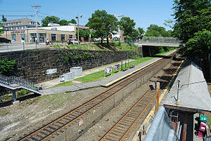
Natick, MassachusettsStation statistics Address 1 Walnut Street
Natick, MA 01760-3503Coordinates 42°17′09″N 71°20′50″W / 42.2858°N 71.3472°WCoordinates: 42°17′09″N 71°20′50″W / 42.2858°N 71.3472°W Lines Connections MWRTA Natick Commuter Shuttle Platforms 2 side platforms Tracks 2 Parking 71 spaces (Town permit required) Other information Fare zone 4 Services Preceding station MBTA Following station toward WorcesterFramingham/Worcester Line toward South StationNatick is a below-grade MBTA Commuter Rail station serving Downtown Natick/Natick Center, Massachusetts, as well as Wayland and Dover. The station is located on the MBTA's Framingham/Worcester Line. Utilizing tracks formerly laid by the Boston & Albany Railroad, the outbound side also generates a spur to Saxonville and Framingham (the Cochituate Rail Trail, formerly the Saxonville Branch).
The station is located on North and South Avenues at the intersection of Walnut Street (north side) and Main Street (north and south side), behind Eastern Bank.[1][2]
As of December 5, 2006, weekday evening rush-hour outbound trains board operate on Track 2 (inbound side) and inbound trains operate on Track 1.
The MWRTA picks up on the North side of the station, coordinated with commuter rail train arrival and departure times.[3]
Natick station has a parking lot with 71 spaces, including 4 accessible spaces. A permit from the town of Natick must be obtained to use the parking lot; the lot is owned and operated by the town.
Natick Station is not handicapped accessible.
Notable station features
The 3.87-mile (6.23 km) spur to Saxonville was established in 1846.
To create the station, Boston and Albany Railroad took advantage of eminent domain to take land owned by the Harrison Harwood Baseball Manufacturing Company. The baseball factory is now a condominium overlooking the train station.
The inbound side of the station is supported by a retaining wall decorated with a colorful mural of the Downtown Natick area. This mural features the train station, Natick Common, the Natick Fire Station, the Harwood Baseball Factory, and Casey's Hot Dog Stand.
References
- ^ "Natick". MBTA. 2008. http://www.mbta.com/schedules_and_maps/rail/lines/stations/default.asp?stopId=25184&lat=42.285239&lng=-71.347641. Retrieved 2008-03-04.
- ^ "Framingham/Worcester Line timetable". MBTA. 2008. http://www.mbta.com/schedules_and_maps/rail/lines/?route=WORCSTER. Retrieved 2008-03-04.
- ^ "Natick bus schedule". Town of Natick, Massachusetts. http://natickma.virtualtownhall.net/Public_Documents/NatickMA_CommDev/bussched.htm. Retrieved 2008-03-04.
External Links
Categories:- Stations along Boston and Albany Railroad lines
- MBTA Commuter Rail stations in Middlesex County, Massachusetts

Wikimedia Foundation. 2010.